Wood County, West Virginia facts for kids
Quick facts for kids
Wood County
|
|
|---|---|

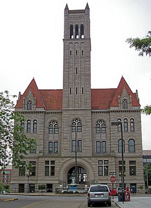
The Wood County Courthouse in Parkersburg
|
|

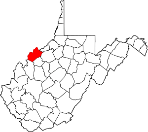
Location within the U.S. state of West Virginia
|
|
 West Virginia's location within the U.S. |
|
| Country | |
| State | |
| Founded | December 21, 1798 |
| Named for | James Wood |
| Seat | Parkersburg |
| Largest city | Parkersburg |
| Area | |
| • Total | 377 sq mi (980 km2) |
| • Land | 367 sq mi (950 km2) |
| • Water | 11 sq mi (30 km2) 2.8%% |
| Population
(2020)
|
|
| • Total | 84,296 |
| • Estimate
(2021)
|
83,624 |
| • Density | 223.60/sq mi (86.33/km2) |
| Time zone | UTC−5 (Eastern) |
| • Summer (DST) | UTC−4 (EDT) |
| Congressional district | 1st |
Wood County is a county located in the state of West Virginia in the United States. As of the 2020 census, about 84,296 people lived there. This makes it the fifth-most populated county in West Virginia.
The main city and county seat is Parkersburg. Wood County was created in 1798. It was formed from the western part of Harrison County. The county is named after James Wood. He was the governor of Virginia from 1796 to 1799.
Wood County is part of the larger Parkersburg-Vienna, WV Metropolitan Statistical Area. This means it's part of a region with several connected cities and towns.
Contents
History of Wood County
Wood County was officially formed on December 21, 1798. It was created from parts of Harrison County. The county was named after James Wood. He was the Governor of Virginia at that time. Before becoming governor, James Wood was a brigadier general in the American Revolutionary War.
How West Virginia Became a State
In 1861, Virginia decided to leave the Union. However, many people in the western counties of Virginia did not agree with this decision. These western counties formed their own government. They decided to separate from the rest of Virginia.
This led to the creation of a new state. West Virginia officially became a state in 1863.
Local Government Changes
After West Virginia became a state, its counties were divided into areas called civil townships. The idea was to help local governments work better. But this plan was hard to follow in a state with many rural areas.
So, in 1872, the townships were changed. They became what are now called magisterial districts. Wood County was divided into ten of these districts. These districts include Clay, Harris, Lubeck, Parkersburg, Slate, Steele, Tygart, Union, Walker, and Williams.
Geography and Rivers
Wood County covers a total area of about 377 square miles. Of this, 366 square miles is land. The remaining 11 square miles, or 2.8%, is water.
Important Waterways
The northern and western border of Wood County is the Ohio River. This is a very important river in the region.
The Little Kanawha River also flows through the county. It moves northwestward and joins the Ohio River in Parkersburg. Smaller streams that flow into the Little Kanawha River in Wood County include Worthington Creek, Tygart Creek, and Walker Creek.
Major Roads in Wood County
Getting around Wood County is made easy by several important highways. These roads connect different parts of the county and link it to other areas.
 Interstate 77
 U.S. Route 50
 West Virginia Route 2
 West Virginia Route 14
 West Virginia Route 31
 West Virginia Route 47
 West Virginia Route 68
 West Virginia Route 95
Neighboring Counties
Wood County shares its borders with several other counties. Some are in West Virginia, and others are in Ohio.
- Washington County, Ohio (north)
- Pleasants County (northeast)
- Ritchie County (east)
- Wirt County (southeast)
- Jackson County (south)
- Meigs County, Ohio (southwest)
- Athens County, Ohio (west)
Protected Natural Areas
Part of the Ohio River Islands National Wildlife Refuge is located in Wood County. This refuge helps protect wildlife and their habitats along the Ohio River.
People and Population
The population of Wood County has changed over many years. Here's a look at how the number of people living there has grown:
| Historical population | |||
|---|---|---|---|
| Census | Pop. | %± | |
| 1800 | 1,217 | — | |
| 1810 | 3,036 | 149.5% | |
| 1820 | 5,860 | 93.0% | |
| 1830 | 6,429 | 9.7% | |
| 1840 | 7,923 | 23.2% | |
| 1850 | 9,450 | 19.3% | |
| 1860 | 11,046 | 16.9% | |
| 1870 | 19,000 | 72.0% | |
| 1880 | 25,006 | 31.6% | |
| 1890 | 28,612 | 14.4% | |
| 1900 | 34,452 | 20.4% | |
| 1910 | 38,001 | 10.3% | |
| 1920 | 42,306 | 11.3% | |
| 1930 | 56,521 | 33.6% | |
| 1940 | 62,399 | 10.4% | |
| 1950 | 66,540 | 6.6% | |
| 1960 | 78,331 | 17.7% | |
| 1970 | 86,818 | 10.8% | |
| 1980 | 93,648 | 7.9% | |
| 1990 | 86,915 | −7.2% | |
| 2000 | 87,986 | 1.2% | |
| 2010 | 86,956 | −1.2% | |
| 2020 | 84,296 | −3.1% | |
| 2021 (est.) | 83,624 | −3.8% | |
| U.S. Decennial Census 1790–1960 1900–1990 1990–2000 2010–2020 |
|||
Facts from the 2010 Census
In 2010, there were 86,956 people living in Wood County. There were 36,571 households and 24,262 families. The population density was about 237 people per square mile.
Most people in the county were white (96.4%). About 1.1% were black or African American. Other groups included Asian, American Indian, and people of two or more races. About 0.9% of the population was of Hispanic or Latino origin.
Many people living in Wood County have German (22.3%), American (19.6%), English (13.7%), or Irish (13.6%) backgrounds.
The average age of people in Wood County was 42.2 years. About 29.1% of households had children under 18 living with them. The average household had 2.35 people.
The median income for a household was $42,146. For a family, it was $52,058. This means half of the households earned more than this amount, and half earned less. About 16.4% of all people in the county lived below the poverty line. This included 25.3% of those under 18.
Communities in Wood County
Wood County has several different types of communities. These include cities, a town, special districts, and smaller unincorporated areas.
Cities in Wood County
- Parkersburg (This is the county seat, where the main government offices are.)
- Vienna
- Williamstown
Town in Wood County
Magisterial Districts
These are local government areas within the county:
- Clay
- Harris
- Lubeck
- Parkersburg
- Slate
- Steele
- Tygart
- Union
- Walker
- Williams
Census-Designated Places (CDPs)
CDPs are areas that look like towns but are not officially incorporated.
Unincorporated Communities
These are smaller communities that do not have their own local government.
See also
 In Spanish: Condado de Wood (Virginia Occidental) para niños
 | Percy Lavon Julian |
 | Katherine Johnson |
 | George Washington Carver |
 | Annie Easley |


