
2024 Noto earthquake facts for kids
| 令和6年能登半島地震 (2024 Noto Peninsula earthquake) | |
.jpg) .png) 
|
|

 |
|
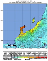
| UTC time | 2024-01-01 07:10:09 |
|---|---|
| ISC event | 636373819 |
| USGS-ANSS | ComCat |
| Local date | 1 January 2024 |
| Local time | 16:10:09 JST (UTC+9) |
| Duration | c. 50 seconds |
| Magnitude | 7.6 MJMA 7.5 Mw |
| Depth | 10 km (6 mi) (USGS) 16 km (10 mi) (JMA) |
| Epicenter | 37°29′17″N 137°16′16″E / 37.488°N 137.271°E |
| Type | Reverse |
| Areas affected | Ishikawa Prefecture, Chūbu region, Japan |
| Total damage | US$17.6 billion (estimated) |
| Max. intensity | JMA 7 |
| Peak acceleration | 2.88 g (2,826 gal) |
| Tsunami | 6.58 m (21.6 ft) |
| Landslides | Yes |
| Foreshocks | 5.7 MJMA |
| Aftershocks | 8,582 total; 169 of M ≥ 4; Largest: 6.1 MJMA or 6.2 mb |
| Casualties | 299 fatalities, 1,327 injuries, 3 missing |
On January 1, 2024, a very strong earthquake hit the Noto Peninsula in Ishikawa Prefecture, Japan. It happened at 4:10 PM Japan time. The earthquake had a magnitude of 7.6, which is very powerful. It caused a lot of shaking and a large tsunami (giant ocean wave).
The earthquake caused widespread damage, especially in towns like Suzu, Wajima, Noto, and Anamizu. Nearby areas like Toyama and Niigata also felt significant effects. Sadly, 299 people died, mostly in Ishikawa. Over 1,300 people were injured, and more than 156,000 buildings were damaged.
This earthquake was the deadliest in Japan since the big 2011 Tōhoku earthquake and tsunami in 2011. Many people had to leave their homes and stay in shelters. The Japan Meteorological Agency (JMA) officially named it the "2024 Noto Peninsula Earthquake." It also led to Japan's first major tsunami warning since the 2011 event. A tsunami wave as high as 6.58 meters (about 21 feet) was measured along the Sea of Japan coast.
Contents
- Understanding Earthquakes: How Plates Move
- The Main Earthquake Event
- The Tsunami: Ocean Waves After the Quake
- People Affected: Casualties and Injuries
- Widespread Impact and Damage
- Aftermath: Recovery and Challenges
- Reactions: Support and Messages
- Misinformation: False Information Spreading
- Gallery
- See also
Understanding Earthquakes: How Plates Move
The Noto Peninsula is located near the edge of the Sea of Japan. This area is where different parts of the Earth's crust, called tectonic plates, meet and push against each other. Japan sits on the boundaries of several of these plates. When these plates move or collide, they can cause earthquakes.
Along Japan's west coast, two plates, the Amurian and Okhotsk Plates, are pushing together. This pressure can cause faults (cracks in the Earth's crust) to move. These movements can lead to strong earthquakes and sometimes tsunamis. In the past, there have been several major earthquakes and tsunamis in this region.
Many Small Earthquakes Before the Big One

For three years before the main earthquake, the Noto Peninsula had many small earthquakes. This is called an earthquake swarm. The biggest one before the main shock was a magnitude 6.5 earthquake in May 2023. The January 1, 2024, earthquake was the strongest ever recorded in the peninsula since 1885.
Scientists think these smaller earthquakes might have been caused by fluids moving deep inside the Earth. These fluids could have made the faults slippery, causing them to move and create earthquakes. Even though many small quakes happened, a large earthquake like the one on January 1st was still considered unusual for the area.
The Main Earthquake Event
The United States Geological Survey (USGS) reported the earthquake's magnitude as 7.5, and the Japan Meteorological Agency (JMA) reported it as 7.6. This was the biggest earthquake to hit Ishikawa Prefecture since at least 1885. It was also the largest to hit mainland Japan since the 2011 Tohoku earthquake.
The earthquake happened when a fault deep underground moved. Just four minutes before the main earthquake, a smaller magnitude 5.8 earthquake occurred. Nine minutes after the main shock, a magnitude 6.2 aftershock (a smaller earthquake that follows a larger one) hit. More than 1,200 aftershocks were recorded in the area.

The fault that caused the earthquake stretched for about 160 kilometers (100 miles). Most of the movement happened under the Noto Peninsula. In some places, the ground moved by as much as 6 meters (about 20 feet). The entire shaking process lasted about 50 seconds.
Scientists are still studying the earthquake. Some believe there's still a chance for another large earthquake and tsunami in the future because part of the fault might not have moved much during this event.
Changes to the Ground and Landslides
The earthquake caused the coastline in some areas to rise by up to 4 meters (13 feet). This made the shore move outwards by as much as 200 meters (656 feet) in places like Suzu, Wajima, and Shika. For example, a fishing port in Wajima was lifted so much that the seafloor became exposed.
The Geospatial Information Authority of Japan (GSI) reported that parts of the country shifted up to 1.3 meters (4.3 feet) to the west. This was most noticeable in Wajima. The land area of the Noto Peninsula actually expanded by about 4.4 square kilometers (1.7 square miles) due to this uplift. It's thought that this rising land might have helped reduce the impact of the tsunami in some areas.


Many landslides occurred across the mountainous parts of the peninsula. About 1,000 landslides were counted. Some of these landslides created "landslide dams," which are natural dams formed by debris. These dams can be dangerous if they break and cause floods.
How Strong Was the Shaking?
The JMA reported a maximum seismic intensity of 7, which is the highest level on their scale. This means the shaking was extremely strong. It was the first time this intensity was recorded in Japan since 2018. The strongest shaking was felt in Shika and Wajima.
The earthquake was felt far away, even in Tokyo and other parts of Japan, from the northern tip of Honshu to Kyushu in the south. In some areas, the ground shaking was almost as strong as during the 2011 Tohoku earthquake.
| Intensity | Prefecture | Locations |
|---|---|---|
| 7 | Ishikawa | Shika, Wajima |
| 6+ | Ishikawa | Anamizu, Nanao, Suzu |
| 6− | Ishikawa | Nakanoto, Noto |
| Niigata | Nagaoka | |
| 5+ | Ishikawa | Hakui, Hōdatsushimizu, Kanazawa, Komatsu, Kaga, Kahoku, Nomi |
| Niigata | Sanjō, Kashiwazaki, Mitsuke, Minamiuonuma, Kariwa, Itoigawa, Myōkō, Jōetsu, Chūō-ku, Minami-ku, Nishi-ku, Nishikan-ku, Tsubame, Aga, Sado | |
| Toyama | Toyama, Funahashi, Takaoka, Himi, Oyabe, Nanto, Imizu | |
| Fukui | Awara | |
| 5− | Ishikawa | Hakusan, Tsubata, Uchinada |
| Niigata | Ojiya, Kamo, Tōkamachi, Izumozaki, Kita-ku, Higashi-ku, Kōnan-ku, Akiha-ku, Gosen, Agano | |
| Toyama | Namerikawa, Kurobe, Kamiichi, Tateyama, Asahi, Tonami | |
| Fukui | Fukui, Sakai | |
| Nagano | Nagano, Shinano, Sakae | |
| Gifu | Takayama, Hida |
Aftershocks: More Shaking Follows
After the main earthquake, there were many aftershocks. These are smaller earthquakes that happen as the Earth's crust settles after a big quake. The largest aftershock was a magnitude 6.2.
Scientists recorded over 8,500 aftershocks in the days following the main earthquake. Most of these were small, but some were strong enough to be felt.
| Time (JST) | Epicenter | Magnitude (USGS) |
Intensity (Shindo) |
Depth | Notes |
|---|---|---|---|---|---|
| 1 January 16:18:42 | 37°11′24″N 136°49′37″E / 37.190°N 136.827°E | mb 6.2 | 5+ | 10 km (6 mi) | |
| 1 January 16:56:48 | 37°18′00″N 136°53′17″E / 37.300°N 136.888°E | Mww 5.6 | 5+ | 10 km (6 mi) (USGS) 20 km (12 mi) (JMA) |
|
| 1 January 17:22:11 | 37°27′47″N 137°13′26″E / 37.463°N 137.224°E | mb 4.9 | 5- | 10 km (6 mi) | |
| 1 January 18:03:49 | 37°32′02″N 137°25′08″E / 37.534°N 137.419°E | mb 5.5 | 5- | 10 km (6 mi) (USGS) 20 km (12 mi) (JMA) |
|
| 1 January 18:08:17 | 37°30′54″N 137°24′11″E / 37.515°N 137.403°E | mb 5.6 | 5- | 10 km (6 mi) | |
| 1 January 18:40:00 | 37°08′53″N 136°39′22″E / 37.148°N 136.656°E | mb 5.0 | 5- | 10 km (6 mi) | |
| 1 January 20:35:32 | 37°09′58″N 136°41′42″E / 37.166°N 136.695°E | mb 4.6 | 5- | 10 km (6 mi) | |
| 2 January 10:17:31 | 37°14′49″N 136°46′08″E / 37.247°N 136.769°E | Mww 5.4 | 5- | 6 km (4 mi) (USGS) 10 km (6 mi) (JMA) |
|
| 2 January 17:13:41 | 37°08′31″N 136°41′06″E / 37.142°N 136.685°E | mb 4.7 | 5+ | 10.9 km (7 mi) | |
| 3 January 02:21:47 | 37°28′48″N 137°19′08″E / 37.480°N 137.319°E | Mww 4.8 | 5+ | 10 km (6 mi) | |
| 3 January 10:54:34 | 37°21′07″N 136°55′41″E / 37.352°N 136.928°E | Mww 5.3 | 5+ | 10 km (6 mi) | |
| 6 January 05:26:51 | 37°13′23″N 136°49′37″E / 37.223°N 136.827°E | Mww 5.1 | 5+ | 10 km (6 mi) | |
| 6 January 23:20:23 | 37°11′56″N 136°41′35″E / 37.199°N 136.693°E | mb 4.5 | 6- | 10 km (6 mi) | |
| 9 January 17:59:10 | 37°52′23″N 137°46′52″E / 37.873°N 137.781°E | Mww 5.9 | 5- | 10 km (6 mi) | |
| 16 January 18:42:16 | 37°07′52″N 136°47′53″E / 37.131°N 136.798°E | mb 4.7 | 5- | 10 km (6 mi) | |
| 2 June 06:31:38 | 37°27′25″N 137°14′20″E / 37.457°N 137.239°E | Mww 5.8 | 5+ | 4.8 km (3 mi) |
|
|
The Tsunami: Ocean Waves After the Quake

After the earthquake, many parts of Japan's western coast received a tsunami warning. People in Ishikawa, Niigata, Toyama, and Yamagata prefectures were told to evacuate. This was the first major tsunami warning in Japan since the 2011 Tohoku earthquake.
Public broadcaster NHK warned that tsunami waves could be as high as 5 meters (16 feet). About 62,000 people were told to leave their homes. Many found shelter at a military base in Wajima. The major tsunami warning was later lowered to a regular warning, and then to an advisory, before being lifted completely about 18 hours after the earthquake.
Along the Noto Peninsula, the tsunami flooded about 370 hectares (914 acres) of land. The first waves arrived very quickly, sometimes within a minute of the earthquake. This meant many people didn't have enough time to evacuate. Scientists think this might be because the earthquake fault was very close to the coast.
In Suzu, the highest waves were over 4.7 meters (15 feet) tall, destroying homes and seawalls. In Shika, a tsunami of 5.1 meters (16.7 feet) was recorded. Even the Shika Nuclear Power Plant recorded a 3-meter (10-foot) rise in tide level, but it was built high enough to avoid damage.
Smaller tsunami waves were also recorded in other cities like Kanazawa (90 cm or 3 feet) and Toyama (80 cm or 2.6 feet). Waves also reached other parts of Japan, including Hokkaido. The highest tsunami wave measured was 6.58 meters (21.6 feet) at a public park near the Seki River mouth. This wave swept people away.
Tsunami Damage and Impact
.jpg)
In Suzu, the tsunami arrived very quickly after the earthquake. Homes were washed away or pushed inland. At least two people died directly from the tsunami in one district, but the total number of tsunami-related deaths might be higher. The earthquake and tsunami damaged or destroyed 90% of the buildings in Suzu. Many fishing boats were overturned or carried onto land.
In Shika, the tsunami damaged the fishing port and its facilities. The coastal uplift caused by the earthquake made it harder to measure the exact tsunami heights, as the land itself had risen.
In the Shiromaru area of Noto, Ishikawa, homes were washed away, and fires started. On Hegurajima, the tsunami flooded homes and cut off basic services. Three people were stuck on the island for two weeks before being rescued. The highest tsunami run-up (how far inland the water went) on the island was 6.28 meters (20.6 feet).
In Jōetsu, Niigata, high waves flooded 15 homes along the Seki River. Beach houses and other buildings were also swept away. Many fishing boats capsized, and warehouses were flooded. Overall, the tsunami flooded about 190 hectares (470 acres) of land in Suzu, Noto, and Shika. At least 120 boats were sunk or overturned, and 70% of ports in Ishikawa Prefecture were damaged.
People Affected: Casualties and Injuries

The earthquake caused 299 confirmed deaths, all in Ishikawa Prefecture. Most deaths were in Wajima (130) and Suzu (114). Over 80% of the deaths were caused by homes collapsing.
Two people died directly from the tsunami, but the total number of tsunami-related deaths could be higher, possibly 26. More than 1,200 people were injured in Ishikawa Prefecture, with 333 seriously hurt. As of July 2024, three people were still missing.
Most of the victims died from being crushed by falling debris, suffocation, or hypothermia (getting too cold). More than 70% of those who died were elderly. Local officials are still reviewing cases to see if more deaths can be officially linked to the disaster.
Widespread Impact and Damage
The Japanese government estimates the total cost of damage in Ishikawa, Toyama, and Niigata prefectures to be around ¥2.6 trillion (about $17.6 billion USD). Most of this cost comes from damaged homes, roads, ports, and other important structures.
Many collapsed houses in Wajima were older wooden buildings built before modern earthquake safety rules were put in place in 1981. In Suzu, many buildings were also old, and only about half were considered earthquake-resistant.
Over 112,000 buildings were damaged across Ishikawa Prefecture, including more than 80,000 houses. In Wajima, over 2,200 houses completely collapsed. A large fire also broke out in Wajima, destroying about 200 buildings, including the famous Asaichi morning market. Firefighters had trouble reaching the fire because roads were damaged and water supplies were cut off.

In Suzu, 90% of buildings were affected, with over 1,700 houses completely collapsing. Previous earthquakes in the area had already weakened many homes. The mayor of Suzu said that 4,000 to 5,000 of the city's 6,000 households were no longer safe to live in.
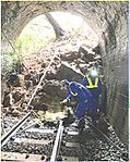
The Noto Airport was closed because of cracks on its runway, leaving about 500 passengers stranded. Roads leading to the northern Noto Peninsula were also blocked by damage and landslides.
In Niigata Prefecture, over 50 people were injured, and more than 21,000 buildings were damaged. Many areas experienced liquefaction, where the ground becomes like liquid during shaking, causing buildings to sink or tilt. Water pipes also broke, leaving many homes without water.
Power outages affected over 36,000 households and 19 medical facilities. Even a month after the earthquake, about 37,000 households still had no water.
The earthquake also damaged 276 schools and 20 cultural sites. Some schools were used as evacuation shelters. Sadly, about 350 people in shelters got sick with COVID-19 or the flu.
Aftermath: Recovery and Challenges
The earthquake had a huge impact on the economy of the affected regions. Businesses closed, and tourism suffered. For example, 10,000 hotel bookings were canceled in Toyama Prefecture alone.
Nine days after the earthquake, two whale sharks at the Notojima Aquarium died because equipment was damaged, making their living conditions poor. In total, about 5,000 sea creatures died at the aquarium.
There were also reports of problems like theft from damaged homes and evacuation centers. Police promised to install more security cameras to prevent this.
Some people criticized the government for being slow to respond. Many temporary homes were needed, but only a few hundred were built in the first month and a half. This left thousands of people still living in shelters. The earthquake also caused many young people to leave the affected region, which makes it harder to rebuild.
Reactions: Support and Messages
From Japan
Japan's Emperor Naruhito and Empress Masako canceled their traditional New Year appearance due to the earthquake. They expressed their sympathy and wished for quick rescue efforts. The Emperor later visited the Noto Peninsula to offer his condolences and support.
The Prime Minister, Fumio Kishida, also postponed a New Year visit to a shrine. The Tokyo Stock Exchange held a moment of silence for the victims. Toyota delayed starting its car production for the year because some of its suppliers were damaged by the earthquake.
From Around the World
Leaders from other countries sent messages of support. North Korean leader Kim Jong Un sent a telegram to Japan's Prime Minister, which was a rare event. The Prime Ministers of Australia and the Philippines offered help. The International Monetary Fund and Pope Francis also sent their prayers. The United States offered military help, food, and aid.
In China, a news anchor was suspended for saying the earthquake was punishment for Japan releasing treated water from the Fukushima nuclear plant. This was an example of misinformation.
Misinformation: False Information Spreading
After the earthquake, a lot of false information spread on social media, especially on Twitter. People shared old videos or photos from other disasters, claiming they were from the Noto earthquake. Some accounts even pretended to be victims to ask for donations online.
There were also false claims that the earthquake was "man-made" or caused by nuclear tests. Japanese public broadcaster NHK found that many of these false claims, especially fake rescue requests, came from accounts outside Japan.
Even a former Japanese Prime Minister incorrectly claimed that the earthquake caused a fire at the Shika Nuclear Power Plant and suggested the impacts were being hidden. While there was a small oil spill at the plant, there was no fire or major damage. It's important to be careful about what you see and hear online, especially during emergencies.
Gallery
-
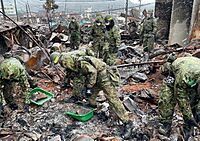
Japan Self-Defense Forces in Wajima
-
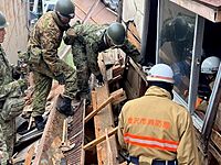
Rescue troops in Kanazawa
-
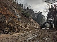
Road clearance
-
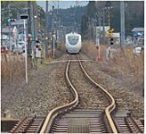
Distorted railway line between Nanao and Wakuraonsen Stations
-
Landslide between Notokashima and Anamizu Stations
-
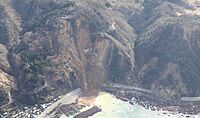
Coastal landslide
-
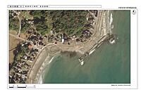
Coastal uplift and tsunami damage in Suzu
-
Damage to Anamizu Station


.jpg)
.jpg)
.jpg)
.jpg)
_as.jpg)
See also
 In Spanish: Terremoto de la península de Noto de 2024 para niños
- List of earthquakes in 2024
- List of earthquakes in Japan
- List of tsunamis
- 2007 Noto earthquake
