
Borough of Ambler facts for kids
Quick facts for kids
Borough of Ambler
|
||
|---|---|---|
.jpg)
The historic Ambler Theater
|
||
|
||

Location of Ambler in Montgomery County, Pennsylvania
|
||

Borough of Ambler
Location in Pennsylvania

Borough of Ambler
Location in the United States
|
||
| Country | United States | |
| State | Pennsylvania | |
| County | Montgomery | |
| Settled | 1682 | |
| Government | ||
| • Type | Council-manager | |
| Area | ||
| • Total | 0.85 sq mi (2.21 km2) | |
| • Land | 0.85 sq mi (2.21 km2) | |
| • Water | 0.00 sq mi (0.00 km2) | |
| Elevation | 220 ft (70 m) | |
| Population
(2020)
|
||
| • Total | 6,807 | |
| • Density | 7,989.44/sq mi (3,083.89/km2) | |
| Time zone | UTC-5 (EST) | |
| • Summer (DST) | UTC-4 (EDT) | |
| ZIP Code |
19002
|
|
| Area codes | 215, 267, and 445 | |
| FIPS code | 42-02264 | |

Ambler is a small town, called a borough, located in Montgomery County, Pennsylvania, in the United States. It's about 16 miles (26 km) north of the big city of Philadelphia.
Contents
History of Ambler
Early Settlers: The Lenape People
The land where Ambler now stands was once home to the Lenape Native American tribe. They lived in the Delaware Valley area, which stretched from Delaware up to New York. The Lenape in this southern part, including Ambler, spoke the Unami language. They made a peace treaty with Quaker leader William Penn in the 1680s.
The Harmer Family and Early Mills
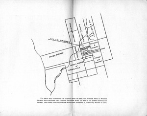
In 1682, William and George Harmer, who were Quakers, came to Pennsylvania. In 1716, they bought a large piece of land, about 408 acres, from William Penn. This land included most of what is now Ambler. They were the first people to settle and live on this land.
William Harmer built a gristmill (a mill for grinding grain) that was powered by the Wissahickon Creek. This was the first business in the Ambler area. He also built a stone house. After he passed away in 1731, his house, mill, and land were sold to Morris Morris and his wife Susanna.
The Village of Wissahickon
The first road in Ambler, now called Mt. Pleasant Avenue, was built in 1730. It connected Harmer's Mill to what is now Bethlehem Pike. Another important road, Butler Pike, was built in 1739. This road went through the town, which was then known as the Village of Wissahickon. It was named after the nearby Wissahickon Creek.
The center of the village was around the crossing of Butler and Bethlehem Pike. It was first called Gilkey's Corner, after an inn built there around 1778. Later, after 1878, this area became known as "Rose Valley."
Over time, more businesses grew in the area. Jonathan Thomas started a tannery (a place that processes animal hides into leather) in 1790. This business was so important that a nearby creek was even nicknamed "Tannery Run." By the mid-1800s, there were nine mills in the area, making things like flour, timber, paper, and cloth. They used the local waterways for power. However, when steam power became popular in the 1870s, these water-powered mills couldn't keep up and eventually closed.
Mary Johnson Ambler and the Train Wreck

In 1855, the Wissahickon station became a stop on the North Pennsylvania Railroad. A very sad event happened on July 17, 1856, known as the Great Train Wreck of 1856. Two trains crashed head-on, and many people were hurt or died.
Mary Ambler, a local Quaker woman, bravely walked two miles to the crash site. She brought medical supplies and helped organize rescue efforts. She even turned her own house into a temporary hospital to care for the injured survivors. Because of her heroic actions, the railway company renamed the station "Ambler" in her honor in 1869. The post office also changed its name, and when the town officially became a borough on June 16, 1888, it was named Ambler, too.
The Keasbey and Mattison Company

In 1881, the Keasbey and Mattison Company moved to Ambler. This company made products using asbestos, a natural mineral. Ambler was a good location because it was on a railroad line, making it easy to bring in raw asbestos from Canada and send out finished products. The area also had magnesium carbonate, another material the company needed. The first factory was built in 1883.
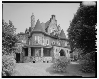
When the company arrived, Ambler was a small town with only about 70 houses and 250 residents. Keasbey and Mattison invested a lot in the town. They hired stoneworkers from Southern Italy to build over 400 houses for their workers and managers. They also built offices, an opera house, a church (Trinity Memorial Episcopal Church), and even the company owner's large home, Lindenwold Castle. Many of the Italian workers stayed in Ambler, which helped shape the town's culture. Today, Ambler has a sister city relationship with Maida, Italy. The company also hired African American workers, who often settled in the west and south parts of Ambler.
By World War I, Ambler was known as the "asbestos capital of the world." However, the Great Depression caused problems for the company, and it was sold to an English company, Turner & Newall, in 1934. The factory continued to operate under the K&M name.
Over time, people learned that breathing in asbestos fibers could cause serious health problems. Doctors began reporting illnesses linked to asbestos exposure. By the 1960s, it was known that even living near an asbestos factory could increase health risks. Turner & Newall ran the factory until it closed in 1962. Later, the Environmental Protection Agency (EPA) began to limit the use of asbestos products.
Cleaning Up the Asbestos Legacy

Because of the asbestos factories, Ambler had a lot of asbestos waste, especially in a 25-acre area called the "White Mountains." This area became a Superfund site, meaning the EPA worked to clean it up. Cleanup efforts took place from 1973 to 1993, and the site was removed from the Superfund list in 1996 after the cleanup was finished. The EPA still checks the site every five years.
Local leaders are working to redevelop these former industrial sites. For example, in 2013, an old factory and smokestack from the Keasbey & Mattison company were turned into a modern, environmentally friendly office building called the Ambler Boiler House. This project used green features like solar panels and a system to reuse water. It shows how Ambler is transforming its past industrial areas into new, sustainable spaces.
Historic Buildings
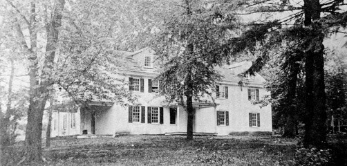
Dawesfield was added to the National Register of Historic Places in 1991. During the American Revolutionary War, this property belonged to James Morris. General George Washington used Dawesfield as his headquarters for about a month in 1777. James Morris also owned one of the mills in the Ambler area.
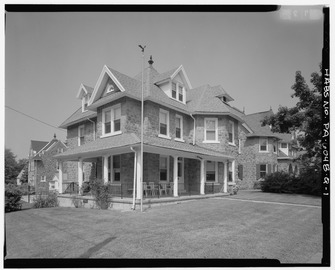
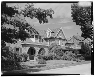
The houses built by the Keasbey-Mattison Company are interesting because they show the different types of homes built for workers, supervisors, and managers. The company owner, Mattison, lived in a very grand home called Lindenwold Castle.
-
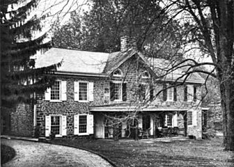
Dawesfield House, 1908
-
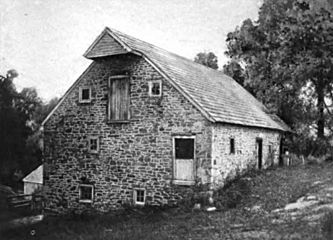
Mill belonging to James Morris, Montgomery County, PA, US, 1908
-
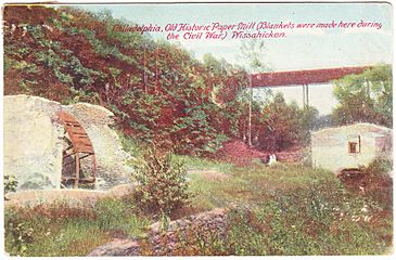
Remains of Paper Mill, Wissahickon Creek, 1908
-
Mary Ambler homestead, c. 1936


-
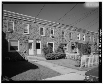
Workman's row houses
-
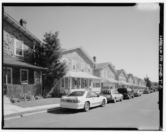
Workman's two-story houses
-
Supervisor's house
-
Supervisor's house
-

Victorian Executive's carriage house/barn
-
Victorian Executive's house
Other interesting buildings, some of which no longer exist, include:
-
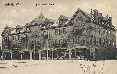
Opera House, 1906
-
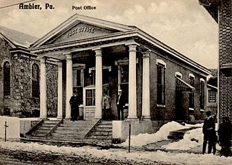
Post office, 1906
-
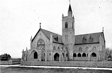
Trinity Memorial Episcopal Church, 1906
-
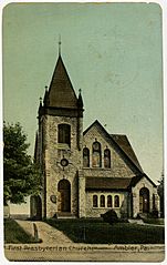
First Presbyterian Church of Ambler


Geography
Ambler is located at 40°9′18″N 75°13′13″W / 40.15500°N 75.22028°W. The U.S. Census Bureau says the borough has a total area of 0.8 square miles (2.2 square kilometers), all of which is land.
Population and People
| Historical population | |||
|---|---|---|---|
| Census | Pop. | %± | |
| 1880 | 251 | — | |
| 1890 | 1,073 | 327.5% | |
| 1900 | 1,884 | 75.6% | |
| 1910 | 2,649 | 40.6% | |
| 1920 | 3,094 | 16.8% | |
| 1930 | 3,944 | 27.5% | |
| 1940 | 3,953 | 0.2% | |
| 1950 | 4,565 | 15.5% | |
| 1960 | 6,765 | 48.2% | |
| 1970 | 7,800 | 15.3% | |
| 1980 | 6,628 | −15.0% | |
| 1990 | 6,609 | −0.3% | |
| 2000 | 6,426 | −2.8% | |
| 2010 | 6,417 | −0.1% | |
| 2020 | 6,807 | 6.1% | |
| Sources: | |||
| Year | Republican | Democratic |
|---|---|---|
| 2020 | 27.6% 1,052 | 71.3% 2,717 |
| 2016 | 27.8% 904 | 67.2% 2,182 |
| 2012 | 31.2% 959 | 67.3% 2,069 |
| 2008 | 30.8% 947 | 68.4% 2,099 |
| 2004 | 33.7% 989 | 65.7% 1,927 |
| 2000 | 35.1% 875 | 60.4% 1,464 |
In 2020, Ambler had a population of 6,807 people. According to the 2010 census, about 76.5% of the people were White, 12.8% were Black or African American, and 3.8% were Asian. About 7.9% of the population had Hispanic or Latino family backgrounds.
In 2000, there were 6,426 people living in Ambler. There were 2,510 households, and 1,598 families. About 30% of households had children under 18. The average household had 2.45 people, and the average family had 3.08 people.
The median age in the borough was 37 years old. This means half the people were younger than 37 and half were older.
Education
Ambler is part of the Wissahickon School District. In 2004, the district had 4,535 students. The Wissahickon School District has six schools:
- four elementary schools
- one middle school (grades 6-8)
- one high school (grades 9-12)
There is also a Catholic elementary school called Our Lady of Mercy Regional Catholic School, located in Maple Glen.
Temple University has a campus called Ambler Campus. While its mailing address is Ambler, it is actually located just outside the borough limits in Upper Dublin Township. This campus was started in 1910 as the Pennsylvania School of Horticulture for Women. It offers many different programs for students.
Arts and Culture

Act II Playhouse
Act II Playhouse is a professional theater with 130 seats. It was started in 1998 and has won several awards for its performances.
Ambler Symphony Orchestra
The Ambler Symphony Orchestra began in 1951. They perform several concerts each year, led by their musical director, Jack Moore.
Ambler Theater
The Ambler Theater first opened in 1927 as a Warner Brothers movie theater. It has been restored and is now a non-profit, community-owned movie theater. It shows independent, art, and special films.
Post Office Mural

From 1934 to 1943, the U.S. government funded murals in post offices across the country. These murals were meant to cheer people up during the Great Depression. In 1939, artist Harry Sternberg created a mural for Ambler's post office called The Family, Industry and Agriculture. The artist and his family are shown as the main figures in the painting.
Notable People
Many interesting people have connections to Ambler:
- Kathleen "Kay" McNulty Mauchly Antonelli - An Irish computer programmer who was one of the first six programmers for the ENIAC, an early electronic digital computer.
- Herbert Raudenbusch Amey, Jr. - A United States Marine Corps lieutenant colonel who received the Silver Star Medal for his service in World War II.
- John Di Domenico - A comedian, actor, and writer.
- Martin Kilson - An American political scientist who was the first Black academic to become a full professor at Harvard University.
- Tanoh Kpassagnon - An American football defensive end who plays for the New Orleans Saints in the NFL.
- John Dallas Cecil Ford - An American Negro league pitcher in the 1910s.
- Michael F. "Mike" Gerber - A former Democratic member of the Pennsylvania House of Representatives.
- Elwood Lewis Richie - A professional baseball pitcher who played in the Major Leagues from 1906 to 1913 for teams like the Chicago Cubs and Philadelphia Phillies.
- Curtis Thomas Simmons - An American former professional baseball left-handed pitcher who played in Major League Baseball from 1947 to 1967.
- David J. Sloane - An American former professional ice hockey defenseman who played one game in the NHL for the Philadelphia Flyers.
- Ruth Williams - A pitcher who played in the All-American Girls Professional Baseball League from 1946 to 1953.
Transportation


Ambler has about 15.72 miles (25.30 km) of public roads. Most of these roads are maintained by the borough itself.
Butler Avenue is the main street that runs through Ambler. Outside the borough, this road is known as Butler Pike. Another important road, Bethlehem Pike, runs along Ambler's eastern edge.
Pennsylvania Route 309 is a freeway that passes east of Ambler. You can get to Ambler from this freeway at certain exits. The Pennsylvania Turnpike (Interstate 276) also has an interchange with PA 309 nearby.
Ambler is served by SEPTA Regional Rail's Lansdale/Doylestown Line. This train line connects Ambler to Center City Philadelphia, Lansdale, Doylestown, and other towns. Ambler station is a big place where people can park their cars and take the train.
SEPTA Suburban Division bus routes 94 and 95 also serve Ambler. Route 94 connects Ambler to the Chestnut Hill area of Philadelphia and the Montgomery Mall. Route 95 connects Ambler to Willow Grove and Gulph Mills.
Sister City
Ambler has a special connection with another town across the world. It is a sister city with:
 Maida, Calabria, Italy
See also
 In Spanish: Ambler (Pensilvania) para niños
