Architecture of Scotland in the Roman era facts for kids
The architecture of Scotland in the Roman era refers to all the buildings and structures made by the Romans within what is now Scotland. This period started when the Romans arrived in northern Britain around the first century BCE. It ended when they left in the fifth century CE. The Romans built many forts and a huge wall called the Antonine Wall. They also influenced the local people's building styles.
Ancient writers like Ptolemy mentioned 19 "towns" in Caledonia. This was the Roman name for the land north of their province of Britannia. However, archaeologists have not found clear evidence of actual towns. These "towns" were probably hillforts. Over 1,000 such forts have been found, mostly south of the Clyde and Forth rivers. Most of these forts seem to have been left empty during the Roman period. There are also unique stone wheelhouses and small underground storage places called souterrains.
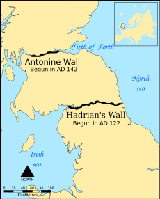
Around 71 CE, the Romans began military trips into what is now Scotland. They built forts, like the one at Trimontium. They likely pushed north as far as the River Tay, building more forts like Inchtuthil. These forts were soon abandoned. By the end of the first century, the Romans occupied only the Southern Uplands. This area was south of a line between the Tyne and Solway Firth. This led to more forts and the building of Hadrian's Wall in northern England. Around 141 CE, they moved north again to build a new frontier. This was a turf wall called the Antonine Wall, the largest Roman structure in modern Scotland. They soon went back to Hadrian's Wall. The Romans made occasional trips north, building and reoccupying forts. Roman power then collapsed in the early fifth century.
Contents
What Was Caledonia Like?
Caledonia was the name the Romans gave to the land north of their province. In his book Geographia, Ptolemy listed 19 "towns" in Caledonia. He may have used older information or accounts from the Agricolan invasion. No real towns have been found by archaeologists from this time. These names might have meant hill forts, temporary markets, or meeting places.
Most of the names are not well known today. Devana might be modern Banchory. Alauna (meaning "the rock") in the west is probably Dumbarton Rock. Another place with the same name in the east might be the site of Edinburgh Castle. Lindon could be Balloch near Loch Lomond.
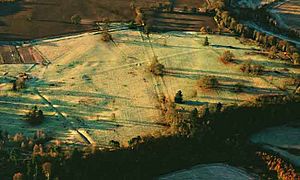
About 1,000 Iron Age hillforts in Scotland have been found. Most are below the Clyde-Forth line. Most are round, with a single wooden fence around an enclosed area. However, they seem to have been mostly empty during the Roman period. There are also many vitrified forts. Their walls were exposed to fire, which might date to this time. But we don't have an exact timeline for them. Studies of a fort at Finavon Hill near Forfar suggest it was destroyed either in the last two centuries BCE or around 500 CE. Many of these forts were used again after the Romans left.
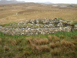
Beyond the Roman-occupied area, in the west and north, there are over 60 wheelhouses. These might have grown from earlier Atlantic roundhouses. They have an outer wall around a circle of stone pillars. These pillars look a bit like the spokes of a wheel.
Over 400 souterrains, which are small underground buildings, have been found in Scotland. Many are in the south-east. Few have been dated, but those that have suggest they were built in the second or third centuries CE. They are usually found near settlements (whose wooden buildings are not as well preserved). Souterrains may have been used for storing food that could spoil easily.
Early Roman Buildings

The Romans started military trips into what is now Scotland around 71 CE. In 78 CE, Gnaeus Julius Agricola became the new governor in Britain. He began a series of big attacks. Two years later, his armies built a large fort at Trimontium near Melrose.
Agricola is said to have pushed his armies to the "River Taus" (thought to be the River Tay). He built forts there, including a large army base at Inchtuthil. After winning against the northern tribes at Mons Graupius in 84 CE, a series of forts and towers were built along the Gask Ridge. This ridge marked the border between the Lowland and Highland areas. It was probably the first Roman limes, or frontier, in Scotland.
Agricola's leaders after him could not, or would not, fully conquer the far north. The fortress at Inchtuthil was taken apart before it was even finished. The other forts on the Gask Ridge were abandoned within a few years. By 87 CE, the Roman occupation was limited to the Southern Uplands. By the end of the first century, the northern edge of Roman control was a line between the Tyne and the Solway Firth.
The Elginhaugh fort in Midlothian dates from this time. Castle Greg in West Lothian might also be from this period. The Romans eventually pulled back to a line in northern England. They built a huge wall there called Hadrian's Wall from one coast to the other.
The Antonine Wall and Later Invasions
Around 141 CE, the Romans decided to reoccupy southern Scotland. They moved north to build a new frontier between the Firth of Forth and the Firth of Clyde. This new wall, the Antonine Wall, is the biggest Roman structure in Scotland.
It is a turf wall, about 20 feet (6 meters) high. It had nineteen forts and stretched for 37 miles (60 kilometers). The stone foundations of the original forts show that the Romans first planned a stone wall like Hadrian's Wall. But this plan was quickly changed. There is a wide ditch on the north side and a military road on the south.
The Romans first planned to build forts every 6 miles (10 kilometers). But this was soon changed to every 2 miles (3 kilometers). One of the best-preserved forts, though also one of the smallest, is Rough Castle Fort. Besides the forts, there are at least nine smaller fortlets. These were probably spaced at Roman mile distances. Some were later replaced by larger forts. The most visible fortlet is Kinneil, at the eastern end of the Wall, near Bo'ness.
The Antonine Wall took twelve years to build. It was taken over and abandoned soon after 160 CE. The Romans then went back to the line of Hadrian's Wall.
Roman troops went far into northern Scotland several more times. There were at least four major campaigns. The Antonine Wall was used again for a short time after 197 CE. The most famous invasion was in 209 CE. Emperor Septimius Severus led a big campaign. A line of forts was built in the north-east. Some of these might have been started during the earlier Antonine campaign. These include camps linked to the Elsick Mounth, like Normandykes, Ythan Wells, Deers Den, and Glenmailen.
Only two forts in Scotland are known to have been used permanently during this invasion. These are at Cramond and Carpow (in the Tay valley). There is evidence that these campaigns happened at the same time as many souterrains in southern Scotland were destroyed and abandoned. This might have been because of Roman military attacks. Or it could have been because local grain markets collapsed after the Romans left. After Severus died in 210 CE, the Romans went back to Hadrian's Wall. This wall remained the frontier until Roman power in Britain ended in the fifth century.
See also
- Architecture of Scotland in the Prehistoric era
- Architecture in Medieval Scotland
- Architecture of Scotland
 | Aurelia Browder |
 | Nannie Helen Burroughs |
 | Michelle Alexander |


