
Aurangabad facts for kids
Quick facts for kids
Aurangabad
|
|
|---|---|
| Chhatrapati Sambhaji Nagar | |
|
From top, then left to right: Bibi Ka Maqbara, Grishneshwar Temple, Carvings in caves of Aurangabad, Prozone Mall
|
|
| Nickname(s):
City of Gates
|
|

Aurangabad
Location in Maharashtra

Aurangabad
Location in India

Aurangabad
Location in Asia
|
|
| Country | |
| State | |
| Region | Marathwada |
| Division | Aurangabad |
| District | Aurangabad |
| Established | 1610 |
| Founded by | Malik Ambar |
| Named for | • Aurangzeb (formerly) • Sambhaji (presently) |
| Government | |
| • Type | Municipal Corporation |
| • Body | Aurangabad Municipal Corporation |
| Area | |
| • Metropolis | 141 km2 (54 sq mi) |
| Elevation | 568 m (1,864 ft) |
| Population
(2011)
|
|
| • Metropolis | 1,175,116 |
| • Rank | India: 32nd Maharashtra: 6th Marathwada: 1st |
| • Density | 8,334/km2 (21,590/sq mi) |
| • Metro | 1,193,167 |
| • Metro rank | 43rd |
| Demonym(s) | Aurangabadkar, Aurangabadi, Sambhajinagarkar |
| Languages | |
| • Official | Marathi |
| • Spoken | Marathi, Urdu, Hindi |
| Time zone | UTC+5:30 (IST) |
| PIN |
431 001
|
| Telephone code 0240 | 0240 |
| Vehicle registration | MH 20 |
| Nominal GDP | $7 billion+ US dollar(2019-20) |


Aurangabad, officially known as Chhatrapati Sambhaji Nagar, is a big city in the Indian state of Maharashtra. It is the main city for the Aurangabad district, Maharashtra and the largest city in the Marathwada region. The city is built on hilly land in the Deccan Traps. It is the fifth most populated city area in Maharashtra, with over 1.1 million people.
Aurangabad is famous for making cotton textiles and beautiful silk fabrics. It also has important schools like Dr. Babasaheb Ambedkar Marathwada University. The city is a popular place for tourists. Nearby are the Ajanta and Ellora caves, which are UNESCO World Heritage Sites. Other cool places to visit include the Aurangabad Caves, Devagiri Fort, Grishneshwar Temple, Jama Mosque, Bibi Ka Maqbara, Himayat Bagh, Panchakki and Salim Ali Lake.
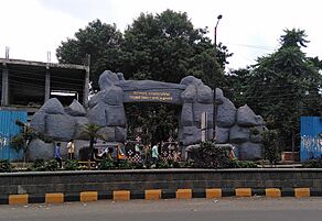
Historically, Aurangabad had 52 Gates in Aurangabad, which is why it's called the "City of Gates." In 2019, the Aurangabad Industrial City (AURIC) became India's first "greenfield" (brand new) industrial smart city. This was part of India's Smart Cities Mission.
Long ago, the imperial capital of the Satavahana dynasty, Paithan, and the capital of the Yadava dynasty, Dēvagirī, were located near modern Aurangabad. In 1308, the Delhi Sultanate took over the region. In 1327, the capital of the Delhi Sultanate was even moved from Delhi to Daulatabad (in present-day Aurangabad). But in 1334, the capital moved back to Delhi.
In 1610, a new city called Khaḍkī was started where Aurangabad is now. It was built by Malik Ambar, an Ethiopian military leader who became a powerful Prime Minister. His son, Fateh Khan, later changed the city's name to Fatehnagar. In 1653, Aurangzeb, a Mughal prince, made Fatehnagar his capital and renamed it "Aurangabad." Later, in 1724, the Mughal governor Nizam Asaf Jah I started his own kingdom, the Hyderabad State, with Aurangabad as its first capital. The capital moved to Hyderabad city in 1763. Aurangabad remained part of Hyderabad State until 1956. In 1960, Aurangabad became part of the state of Maharashtra.
Contents
History of Aurangabad
.jpg)
The city we know as Aurangabad was first a village called Khaḍkī. Malik Ambar, a powerful leader, made it a capital city in 1610. Within ten years, Khaḍkī grew into a large and important city.
After Malik Ambar died in 1626, his son Fateh Khan took over. He changed the city's name to Fatehnagar. In 1633, the Mughals captured the Devagiri Fort. This meant that Fatehnagar and the surrounding areas also came under Mughal control.
In 1653, Mughal prince Aurangzeb became the leader of the Deccan region for the second time. He made Fatehnagar his capital and renamed it Aurangabad. People sometimes called it Khujista Bunyad during Aurangzeb's rule.

In 1681, after becoming emperor, Aurangzeb moved his royal court from Delhi to Aurangabad. He did this to lead his military campaigns in the Deccan. Because many important Mughal people lived there, the city grew a lot. Many public and private buildings were constructed. Around 1683, a city wall was built around Aurangabad to protect it from Maratha attacks. Some of these gates, like the Delhi Gate, are still standing today.
Even though Aurangzeb moved away in 1684, Aurangabad stayed important as the main military base for the Mughal Deccan. This brought wealth to the city and made it a center for trade. Making embroidered silks became popular during this time and is still done in Aurangabad today. Mughal Aurangabad was also a cultural hub, known for Persian and Urdu literature. During the Mughal era, about 200,000 people lived in Aurangabad.
In 1724, Asaf Jah, a Mughal general, decided to start his own kingdom in the Deccan. Aurangabad remained important as the capital of his new kingdom for about 40 years. But in 1763, his son Nizam Ali Khan Asaf Jah II moved the capital to Hyderabad. This made Aurangabad less important, and the city saw a period of economic decline. By the early 1800s, many buildings were falling apart. However, Aurangabad was still the "second city" of the Nizam's kingdom.
In 1816, the British set up a military camp outside Aurangabad. The city started to become industrial in the late 1800s, with its first cotton mill opening in 1889. The population grew from 30,000 in 1881 to 36,000 in the next twenty years.
After India became independent, Hyderabad State joined the Indian Union in 1948. So, Aurangabad became part of the Indian Union's Hyderabad State. In 1956, it became part of the new Bombay State, and in 1960, it joined the state of Maharashtra.
In 1988, Bal Thackeray suggested renaming the city to Sambhajinagar. The local city council passed a resolution for this name change in 1995. On June 29, 2022, the Maharashtra government officially approved renaming Aurangabad to Sambhaji Nagar. This new name honors Sambhaji Bhosale, the second ruler of the Maratha Empire.
Geography and Climate
Aurangabad is located at 19° 53' 47" North and 75° 23' 54" East. The city is surrounded by the Ajanta mountain range.
Climate
Aurangabad has a semiarid climate, which means it's usually dry. The average yearly temperatures range from 17 to 33 degrees Celsius (63 to 91 degrees Fahrenheit). The best time to visit is in winter, from October to February. The highest temperature ever recorded was 46°C (115°F) in May 1905. The lowest was 2°C (36°F) in February 1911. Sometimes, cold air from northern India can make temperatures drop to about 2 to 4°C (36 to 39°F).
Most of the rain falls during the monsoon season, from June to September. Thunderstorms can happen between November and April. The city gets about 710 millimeters (28 inches) of rain each year. It's often cloudy during the monsoon, and the clouds can stay for days. This cloud cover and heavy rain can make the daily high temperature drop to around 22°C (72°F).
| Climate data for Aurangabad (Aurangabad Airport) 1991–2020, extremes 1952–2012 | |||||||||||||
|---|---|---|---|---|---|---|---|---|---|---|---|---|---|
| Month | Jan | Feb | Mar | Apr | May | Jun | Jul | Aug | Sep | Oct | Nov | Dec | Year |
| Record high °C (°F) | 34.2 (93.6) |
37.8 (100.0) |
40.6 (105.1) |
43.6 (110.5) |
43.8 (110.8) |
43.0 (109.4) |
37.1 (98.8) |
35.6 (96.1) |
37.0 (98.6) |
37.6 (99.7) |
34.6 (94.3) |
33.6 (92.5) |
43.6 (110.5) |
| Mean daily maximum °C (°F) | 29.2 (84.6) |
31.8 (89.2) |
35.6 (96.1) |
38.7 (101.7) |
39.6 (103.3) |
34.6 (94.3) |
30.1 (86.2) |
29.2 (84.6) |
30.2 (86.4) |
31.8 (89.2) |
30.5 (86.9) |
29.1 (84.4) |
32.5 (90.5) |
| Daily mean °C (°F) | 21.0 (69.8) |
23.8 (74.8) |
27.9 (82.2) |
31.5 (88.7) |
32.7 (90.9) |
28.8 (83.8) |
26.0 (78.8) |
25.3 (77.5) |
25.8 (78.4) |
25.6 (78.1) |
23.3 (73.9) |
20.9 (69.6) |
26.1 (78.9) |
| Mean daily minimum °C (°F) | 12.4 (54.3) |
14.9 (58.8) |
19.0 (66.2) |
23.1 (73.6) |
25.1 (77.2) |
23.6 (74.5) |
22.4 (72.3) |
21.8 (71.2) |
21.5 (70.7) |
19.1 (66.4) |
15.6 (60.1) |
12.5 (54.5) |
19.2 (66.6) |
| Record low °C (°F) | 1.2 (34.2) |
1.9 (35.4) |
7.1 (44.8) |
10.2 (50.4) |
14.2 (57.6) |
18.2 (64.8) |
18.4 (65.1) |
17.2 (63.0) |
12.6 (54.7) |
8.3 (46.9) |
1.9 (35.4) |
1.2 (34.2) |
1.2 (34.2) |
| Average rainfall mm (inches) | 2.6 (0.10) |
2.2 (0.09) |
11.4 (0.45) |
6.0 (0.24) |
17.4 (0.69) |
155.6 (6.13) |
178.0 (7.01) |
171.5 (6.75) |
172.4 (6.79) |
68.2 (2.69) |
17.5 (0.69) |
8.9 (0.35) |
811.7 (31.96) |
| Average rainy days | 0.3 | 0.2 | 0.9 | 0.6 | 1.2 | 8.0 | 10.9 | 10.0 | 8.4 | 3.9 | 1.1 | 0.5 | 46.1 |
| Average relative humidity (%) (at 17:30 IST) | 40 | 35 | 28 | 27 | 29 | 55 | 71 | 73 | 69 | 53 | 49 | 44 | 48 |
| Average ultraviolet index | 6 | 7 | 8 | 8 | 8 | 7 | 6 | 6 | 7 | 6 | 6 | 6 | 7 |
| Source 1: India Meteorological Department | |||||||||||||
| Source 2: Weather Atlas, Tokyo Climate Center (mean temperatures 1991–2020) | |||||||||||||
Aurangabad is ranked as the 36th best "National Clean Air City" in India among large cities.
Geology

The area around Aurangabad is covered by lava flows from the Deccan Traps. These are ancient volcanic rocks. The soil in Aurangabad is mostly black and formed from these volcanic rocks.
People and Languages

| Historical population | ||
|---|---|---|
| Year | Pop. | ±% |
| 1901 | 10,000 | — |
| 1911 | 34,902 | +249.0% |
| 1921 | 36,876 | +5.7% |
| 1931 | 36,870 | −0.0% |
| 1941 | 50,924 | +38.1% |
| 1951 | 66,636 | +30.9% |
| 1961 | 97,701 | +46.6% |
| 1971 | 165,253 | +69.1% |
| 1981 | 301,000 | +82.1% |
| 1991 | 592,000 | +96.7% |
| 2001 | 902,179 | +52.4% |
| 2011 | 1,421,879 | +57.6% |
| Source: Census of India | ||
In 2011, Aurangabad had a population of about 1.17 million people. About 609,206 were males and 565,910 were females. The city has a good literacy rate, meaning many people can read and write. About 87.5% of people aged 7 and above are literate.
Religions
| Religions in Aurangabad City (2011) | ||||
|---|---|---|---|---|
| Religion | Percent | |||
| Hinduism | 51.07% | |||
| Islam | 30.79% | |||
| Buddhism | 15.17% | |||
| Jainism | 1.62% | |||
| Christianity | 0.85% | |||
| Other or not stated | 0.50% | |||
Most people in Aurangabad are Hindu (51%). After that, about 30% are Muslim and 15.2% are Buddhist. There are also people who follow Jainism, Sikhism, and Christianity.
Languages
Marathi is the official language of Aurangabad. It is also the most spoken language in the city. Other common languages are Urdu and Hindi.
Economy and Industries
Aurangabad is a great example of how a state government can help a region grow industrially. The city was once a major center for making silk and cotton textiles. A special fabric called Himroo was created here, mixing silk with local cotton. Beautiful Paithani silk saris are also made in Aurangabad.
After 1900, with the opening of the Hyderabad-Godavari Valley Railways, many cotton factories started. Since 1960, the Maharashtra Industrial Development Corporation (MIDC) has helped set up industrial areas. The main office for entrepreneurship development in Maharashtra is also in Aurangabad.
Major industries in Aurangabad include manufacturing, biotechnology, medicines, and automobiles. Large companies like Siemens and car makers such as BMW, Audi India, Skoda Auto, and Bajaj Auto have factories here. A big Russian steel company, NLMK, also has a plant in the Shendra industrial area.
Culture and Tourist Spots
Culture
The culture of Aurangabad is very similar to that of Hyderabad. The older parts of the city still show the charm of Muslim culture of Hyderabad. This influence can be seen in the local language and food. While Urdu is one of the main languages, along with Marathi and Hindi, it is spoken in the Dakhni – Hyderabadi Urdu style.
- Wali Dakhni (1667–1731 or 1743) was a famous poet from Aurangabad. He was one of the first poets to write in the Urdu language.
- Abul Ala Maududi (1903–1979), an important Muslim scholar, was born in Aurangabad.
Tourist Attractions
Aurangabad is a city full of history, with many interesting places to visit.
Ancient Rock-Cut Caves
- Aurangabad Caves
-
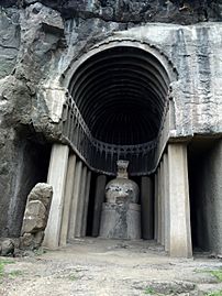
Chaitya with stupa, Cave IV (4), Aurangabad Caves.
-
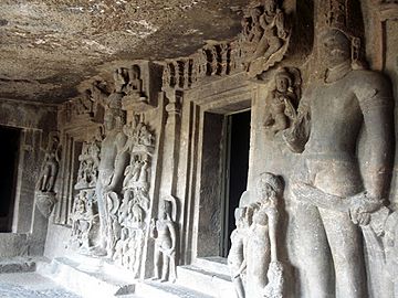
Various sculptors next to an entrance at Aurangabad Caves.


- Aurangabad Caves: These 12 Buddhist caves are about 5 kilometers (3 miles) from the city. They date back to 3 A.D. You can see interesting designs and symbols in the caves.
Hindu and Jain Temples

- Kachner Jain Temple: This temple is 250 years old and is dedicated to Parshvanath. The special idol here is called Chintamani Parshvanath.
Historic Gates and Forts

- City Gates: Aurangabad is famous for its 52 gates, which were built during the Mughal era. This is why it's called the "City of Gates."
Mughal Architecture
_2.jpg)
- Bibi Ka Maqbara: This famous building is about 3 kilometers (2 miles) from the city. It is the burial place of Emperor Aurangzeb's wife, Dilras Banu Begum. It looks a lot like the Taj Mahal in Agra, so it's often called the "Taj of the Deccan." Aurangabad also has parts of the palace built by Aurangzeb, including his royal mosque.
Other Attractions
-
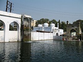
Panchakki, a historic water mill.
-
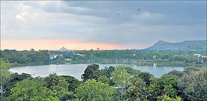
Salim Ali Lake.
-
Siddharth Garden near the bus stand in Aurangabad.


- Panchakki: Panchakki means "water mill." This 17th-century watermill is in the old city. It's known for its underground water channel, which brings water from hills over 8 kilometers (5 miles) away. The water creates a waterfall that powers the mill, showing clever engineering from long ago.
- Salim Ali Lake & Bird Sanctuary: This lake, also known as Salim Ali Talab, is in the northern part of the city. It was once called Khiziri Talab. It's named after the famous bird expert, Salim Ali. It has a bird sanctuary and a garden.
- Siddharth Garden and Zoo: This park and zoo is near the central bus station. It's the only zoo in the Marathwada region. You can see many different animals, birds, flowers, and trees here. It is named after Gautama Buddha.
Special Fabrics
- Himroo: This special fabric is said to have come from Persia. Himroo is known for its unique style and design. Fabrics and shawls from Aurangabad are very popular.
- Kaghzipura: This place near Daulatabad was where the first handmade paper in India was made. The technology was brought here by Mongol invaders.
Cuisine

Aurangabadi food is similar to Mughlai or Hyderabadi cuisine. It features fragrant pulao and biryani. Meat cooked with fresh spices and herbs is a specialty, as are the delicious sweets. The local food mixes Mughal and Hyderabadi styles with the spices of the Marathwada region.
- Naan Qalia is a dish strongly linked to Aurangabad. It's a mix of mutton and various spices. Naan is a type of bread baked in a tandoor (hot oven), and Qalia is the spicy mutton mixture.
Transportation
Air Travel
Aurangabad Airport serves the city. You can find flights to major Indian cities like Hyderabad, Delhi, Mumbai, Bangalore, and Ahmedabad. There are also flights to Bangkok. In 2008, flights were made available for people traveling for the Hajj pilgrimage.

Train Travel
Aurangabad railway station is the main train station. It connects to big cities such as Delhi, Hyderabad, Mumbai, Nagpur, and Pune. There are plans for a metro system in Aurangabad and a high-speed rail line from Mumbai to Nagpur, which will stop in Aurangabad.

Road Travel
The Central Bus Stand and CIDCO bus stand are the main public transport hubs. Buses are available to all major bus depots in Maharashtra. You can also find buses to cities in neighboring states like Indore, Surat, and Bhopal. Aurangabad also has a Smart City Bus service for public transport within the city.
Education

Dr. Babasaheb Ambedkar Marathwada University (BAMU) is located in Aurangabad. Many colleges in the region are connected to this university. It has over 100 colleges affiliated in Aurangabad and many more in nearby districts.
Government College of Engineering, Aurangabad is an engineering college that started in 1960. Marathwada Institute of Technology and Jawaharlal Nehru Engineering College are two other engineering colleges in the city.
Maharashtra National Law University, Aurangabad is a state university that opened in 2017.
Maulana Azad College of Arts and Science was founded in 1963. It is also connected to Dr. Babasaheb Ambedkar Marathwada University.
National Institute of Electronics & Information Technology Aurangabad (NIELIT Aurangabad) is a government engineering institute. It offers various courses in electronics and information technology.
Aurangabad has schools run by the Aurangabad Municipal Corporation (AMC) and private schools. Government Polytechnic Aurangabad is a polytechnic institution in the Marathwada region.
The Institute of Hotel Management, Aurangabad, is connected to the University of Huddersfield. Students often do internships at the Vivanta, Taj hotel in Aurangabad.
Sports
Garware Stadium is the city's municipal stadium. An international-standard cricket stadium is being built at the Aurangabad District Cricket Association Stadium. The Jawaharlal Nehru Engineering College Sports Complex is used for college sports events.
Notable people
- Malik Ambar, a military leader and founder of Khadki (the city's old name)
- Siraj Aurangabadi, an 18th-century Urdu and Persian poet
- Imtiyaz Jaleel, an Indian politician
- Mayuri Kango, a film actress
- Abul A'la Maududi, a Pakistani theologian and philosopher
- Yashraj Mukhate, a musician
- Wali Mohammed Wali, known as the father of Urdu poetry
See also
 In Spanish: Aurangabad (Maharashtra) para niños
