Big Horn County, Wyoming facts for kids
Quick facts for kids
Big Horn County
|
||
|---|---|---|

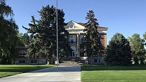
Big Horn County Courthouse
|
||
|
||

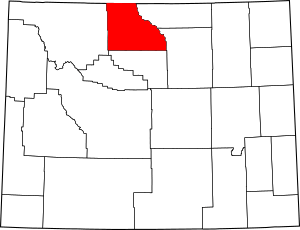
Location within the U.S. state of Wyoming
|
||
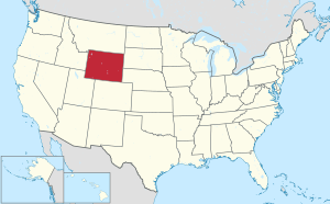
 Wyoming's location within the U.S. |
||
| Country | ||
| State | ||
| Founded | March 12, 1890 (authorized) 1897 (organized) |
|
| Named for | Bighorn Mountains | |
| Seat | Basin | |
| Largest town | Lovell | |
| Area | ||
| • Total | 3,159 sq mi (8,180 km2) | |
| • Land | 3,137 sq mi (8,120 km2) | |
| • Water | 22 sq mi (60 km2) 0.7%% | |
| Population
(2020)
|
||
| • Total | 11,521 | |
| • Estimate
(2023)
|
12,018 |
|
| • Density | 3.6470/sq mi (1.40813/km2) | |
| Time zone | UTC−7 (Mountain) | |
| • Summer (DST) | UTC−6 (MDT) | |
| Congressional district | At-large | |
Big Horn County is a county in the state of Wyoming, USA. It's located in the northern part of Wyoming, right next to the state of Montana. In 2020, about 11,521 people lived here. The main town, or county seat, is Basin.
Contents
History of Big Horn County
Big Horn County was officially created by the Wyoming government in March 1890. It was fully set up and organized in 1897. Its land was taken from parts of Fremont, Johnson, and Sheridan counties.
The county got its name from the Big Horn Mountains. These mountains form the county's eastern border. Originally, Big Horn County was much larger. It included the entire Big Horn Basin. Over time, new counties were formed from its land. Park County was created in 1909. Then, in 1911, Hot Springs and Washakie counties were also formed. This gave Big Horn County its current size and shape.
Around the time of World War I, many people from England and Germany lived in Big Horn County. Even though their home countries were fighting, these groups got along well. People in the county made sure German residents were treated fairly. English ranchers, for example, spoke kindly of their German neighbors. They wanted to avoid any national hatred. This shows how people in Big Horn County valued good relationships.
Geography and Nature
Big Horn County covers a total area of about 3,159 square miles. Most of this land, about 3,137 square miles, is dry land. The rest, about 22 square miles, is water.
Neighboring Counties
Big Horn County shares its borders with several other counties:
- Park County – to the west
- Carbon County, Montana – to the northwest
- Big Horn County, Montana – to the northeast
- Sheridan County – to the east
- Johnson County – to the southeast
- Washakie County – to the south
It's interesting to note that Big Horn County in Wyoming and Big Horn County in Montana share a border. This is one of only ten pairs of counties in the United States that have the same name and touch each other across state lines!
Main Roads and Highways
Several important roads pass through Big Horn County:
Public Transport
- Express Arrow offers bus services in the area.
Protected Natural Areas
Parts of these beautiful natural areas are found within Big Horn County:
Population and People
| Historical population | |||
|---|---|---|---|
| Census | Pop. | %± | |
| 1900 | 4,328 | — | |
| 1910 | 8,886 | 105.3% | |
| 1920 | 12,105 | 36.2% | |
| 1930 | 11,222 | −7.3% | |
| 1940 | 12,911 | 15.1% | |
| 1950 | 13,176 | 2.1% | |
| 1960 | 11,898 | −9.7% | |
| 1970 | 10,202 | −14.3% | |
| 1980 | 11,896 | 16.6% | |
| 1990 | 10,525 | −11.5% | |
| 2000 | 11,461 | 8.9% | |
| 2010 | 11,668 | 1.8% | |
| 2020 | 11,521 | −1.3% | |
| 2023 (est.) | 12,018 | 3.0% | |
| US Decennial Census 1870–2000 2010–2016 |
|||
In 2010, about 11,668 people lived in Big Horn County. The population density was about 3.7 people per square mile. Most residents were white, with smaller groups of American Indian, Asian, and Black people. About 8.4% of the population identified as Hispanic or Latino. The average age of people living here was 41.8 years old.
Education and Schools
Big Horn County has four public school districts. These districts help manage the schools in different parts of the county:
- Big Horn County School District 1
- Big Horn County School District 2
- Big Horn County School District 3
- Big Horn County School District 4
Towns and Communities
Towns
- Basin (This is the county seat, the main town for county government)
- Burlington
- Byron
- Cowley
- Deaver
- Frannie (partly in Park County)
- Greybull
- Lovell
- Manderson
Census-designated places
These are areas that are like towns but are not officially incorporated:
Unincorporated communities
These are smaller communities that are not officially part of a town or city:
See also
 In Spanish: Condado de Big Horn (Wyoming) para niños


