Bourne, Massachusetts facts for kids
Quick facts for kids
Bourne
|
|||
|---|---|---|---|

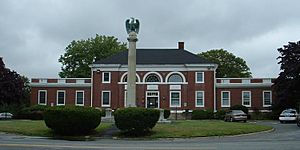
Bourne Town Hall
|
|||
|
|||

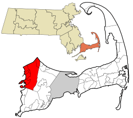
Location in Barnstable County and the state of Massachusetts.
|
|||
| Country | United States | ||
| State | Massachusetts | ||
| County | Barnstable | ||
| Settled | 1640 | ||
| Incorporated | 1884 | ||
| Communities |
|
||
| Government | |||
| • Type | Open town meeting | ||
| Area | |||
| • Total | 52.9 sq mi (136.9 km2) | ||
| • Land | 40.7 sq mi (105.3 km2) | ||
| • Water | 12.2 sq mi (31.6 km2) | ||
| Elevation | 42 ft (13 m) | ||
| Population
(2020)
|
|||
| • Total | 20,452 | ||
| • Density | 503/sq mi (194.2/km2) | ||
| Time zone | UTC−5 (Eastern) | ||
| • Summer (DST) | UTC−4 (Eastern) | ||
| ZIP Code |
02532
|
||
| Area code(s) | 508/774 | ||
Bourne is a town in Barnstable County, Massachusetts, United States. It is located on Cape Cod. In 2020, about 20,452 people lived there.
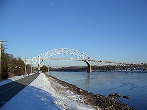
Bourne is known for being the "first" town on Cape Cod. This is because all three bridges that cross the Cape Cod Canal are found here. The canal helps ships avoid a long and dangerous trip around the Cape.
You can find more details about specific areas in Bourne by looking up articles on Bourne (CDP), Buzzards Bay, Monument Beach, Pocasset, Sagamore, and Sagamore Beach.
Contents
History of Bourne
Early Settlement and Naming
Bourne was first settled in 1640 by Ezra Perry. At that time, it was part of the town of Sandwich. People used to call this area "West Sandwich."
Bourne officially became its own town in 1884. It was the last town in Barnstable County to be incorporated. The town was named after Jonathan Bourne Sr., a respected local figure. His family had deep roots in the area.
Historic Landmarks and the Canal
Bourne is home to the Aptucxet Trading Post. This is considered the oldest store in the United States. The Pilgrims built it in 1627. It was a trading spot between two rivers.
Later, the Cape Cod Canal was built in this area. This canal made it much safer and faster for ships to travel. It connects Buzzards Bay to Cape Cod Bay.
Important Sites in Bourne
The Massachusetts Maritime Academy is located in Bourne. This is a special college for students who want to work on ships or in the maritime industry. It sits at the southern end of the canal.
Part of the Otis Air National Guard Base is also in Bourne. This base is important for national defense. It includes a large radar system called PAVE PAWS.
Bourne also has a mystery called the "Bourne stone." It's a stone with strange markings that no one has fully explained.
President Grover Cleveland once had a summer home in Bourne. It was called Gray Gables. He used it as his "Summer White House" from 1893 to 1896. Sadly, the building was destroyed by fire in 1973.
Geography of Bourne
Location and Waterways
Bourne is located at the western end of Cape Cod. The Cape Cod Canal cuts right through the northern part of the town. Bourne shares borders with several other towns. These include Sandwich to the east and Falmouth to the south.
To the west, Bourne borders Marion and Wareham. To the north, it meets Plymouth and Cape Cod Bay. Bourne is about 55 miles (88 km) south of Boston.
Land and Water Features
The town covers about 52.8 square miles (136.9 square kilometers) in total. About 40.6 square miles (105.3 square kilometers) is land. The rest, about 12.2 square miles (31.6 square kilometers), is water.
Bourne's landscape is shaped by Buzzards Bay and the Cape Cod Canal. There are many small peninsulas, locally called "necks," like Wings Neck. These create several small coves and harbors.
The town also has many small ponds and rivers. Most of these flow into Buzzards Bay. Buttermilk Bay is the largest inlet and is located near the border with Wareham.
Natural Areas and Beaches
A large part of the town is taken up by the Otis Air National Guard Base. Because of this, most people live along the shores of the Canal or Buzzards Bay.
Bourne has its own town forest. It also includes a small part of the Shawme-Crowell State Forest. Many beaches can be found along Bourne's shores. Most are along Buzzards Bay, but Sagamore Beach is on Cape Cod Bay.
Climate in Bourne
Bourne has a climate with warm summers and rain throughout the year. The average snowfall from November to April is about 30 inches (76 cm). February is usually the snowiest month.
The area is suitable for growing many types of plants. The lowest winter temperatures usually stay around -1.0°F (-18.3°C).
| Climate data for Bourne, Barnstable County, Massachusetts (1981–2010 averages) | |||||||||||||
|---|---|---|---|---|---|---|---|---|---|---|---|---|---|
| Month | Jan | Feb | Mar | Apr | May | Jun | Jul | Aug | Sep | Oct | Nov | Dec | Year |
| Mean daily maximum °F (°C) | 37.4 (3.0) |
39.3 (4.1) |
45.2 (7.3) |
54.2 (12.3) |
64.2 (17.9) |
73.4 (23.0) |
79.2 (26.2) |
78.3 (25.7) |
71.7 (22.1) |
61.6 (16.4) |
52.8 (11.6) |
42.9 (6.1) |
58.4 (14.7) |
| Daily mean °F (°C) | 29.2 (−1.6) |
31.1 (−0.5) |
37.1 (2.8) |
45.9 (7.7) |
55.6 (13.1) |
65.2 (18.4) |
71.3 (21.8) |
70.4 (21.3) |
63.5 (17.5) |
53.2 (11.8) |
44.5 (6.9) |
34.9 (1.6) |
50.3 (10.2) |
| Mean daily minimum °F (°C) | 21.0 (−6.1) |
22.9 (−5.1) |
28.9 (−1.7) |
37.7 (3.2) |
47.0 (8.3) |
57.0 (13.9) |
63.4 (17.4) |
62.6 (17.0) |
55.3 (12.9) |
44.7 (7.1) |
36.2 (2.3) |
26.8 (−2.9) |
42.1 (5.6) |
| Average precipitation inches (mm) | 4.11 (104) |
3.57 (91) |
5.20 (132) |
4.50 (114) |
3.52 (89) |
3.78 (96) |
3.35 (85) |
3.92 (100) |
3.91 (99) |
4.23 (107) |
4.53 (115) |
4.52 (115) |
49.14 (1,248) |
| Average relative humidity (%) | 67.6 | 66.4 | 64.9 | 65.8 | 68.8 | 72.9 | 74.0 | 75.0 | 75.2 | 72.3 | 69.4 | 68.8 | 70.1 |
| Average dew point °F (°C) | 19.8 (−6.8) |
21.2 (−6.0) |
26.4 (−3.1) |
35.1 (1.7) |
45.5 (7.5) |
56.3 (13.5) |
62.6 (17.0) |
62.1 (16.7) |
55.5 (13.1) |
44.5 (6.9) |
35.1 (1.7) |
25.7 (−3.5) |
40.9 (4.9) |
| Source: PRISM Climate Group | |||||||||||||
Ecology and Nature
Bourne's natural plant life would mostly be a mix of Oak and Pine trees. You would also find some Southern Mixed Forest types.
Education in Bourne
Public Schools
Bourne has its own school system with four public schools. There are two elementary schools: Bournedale Elementary School and Bourne Intermediate School. Bournedale serves students from kindergarten to second grade. Bourne Intermediate School is for grades three through five.
The town's middle school teaches grades six through eight. Bourne High School is for grades nine through twelve. The school colors are purple and white. Their sports teams are called the Canalmen and Lady Canalmen. Their logo features the Railroad Bridge, one of the three bridges over the Cape Cod Canal.
School Achievements
Bourne High School's sports teams have been very successful. They have won state championships in boys' hockey and girls' volleyball. Other teams, like golf and boys' soccer, have also reached state finals.
Other Schools in the Area
Bourne is also home to the Upper Cape Cod Regional Technical School. This school teaches students special skills and trades. It serves students from Bourne and nearby towns.
There is also a private school called The Bridgeview School in Sagamore. It uses the Montessori method of teaching for younger students.
The Massachusetts Maritime Academy is a state college located in Buzzards Bay. It focuses on maritime studies.
Sports in Bourne
Bourne Braves Baseball
Bourne is home to the Bourne Braves. This is a summer baseball team for college players. They play at Doran Park. Many players from the Bourne Braves have gone on to play in Major League Baseball. Famous players like Kevin Youkilis, Mitch Moreland, and Pete Alonso once played for the team.
Transportation in Bourne
Major Roads
Several important highways pass through Bourne. These include Massachusetts Route 3, U.S. Route 6, Massachusetts Route 25, and Massachusetts Route 28. Routes 6 and 28 enter Bourne together from Wareham.
Route 6 then follows the north side of the Cape Cod Canal. Route 28 leads to the Bourne Bridge and Route 25. The Bourne Bridge is one of the main ways to cross the canal.
Rail Service
The third bridge over the Canal is the Cape Cod Canal Railroad Bridge. This is a special bridge that can lift up to let ships pass.
You can take a train called the CapeFlyer from Bourne. It stops at Buzzards Bay station and Bourne station during certain seasons. The Cape Cod Central Railroad also offers fun train rides for tourists.
Air Travel
There are no public airports directly in Bourne. The closest small airports are in Plymouth and Barnstable. For bigger flights, you would go to Logan International Airport in Boston or T. F. Green Airport near Providence.
Notable people
- Sammy Adams, rapper, singer and songwriter
- Bill Arnold, NHL player
- Mark Fayne, NHL player
- Peter Gammons, sportswriter
- Bill Keating, member of the U.S. House of Representatives
- Bobby Orr, famous NHL hockey player
- T. K. O'Ryan, professional wrestler
- Bob Perryman, football player
- Dan Shaughnessy, sportswriter
- Mike Stud, hip-hop recording artist
See also
 In Spanish: Bourne (Massachusetts) para niños


