Chouteau County, Montana facts for kids
Quick facts for kids
Chouteau County
|
|
|---|---|

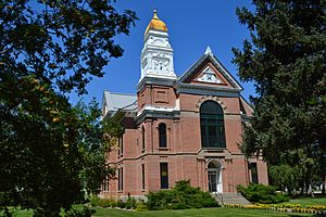
Chouteau County Courthouse in Fort Benton
|
|

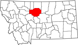
Location within the U.S. state of Montana
|
|
 Montana's location within the U.S. |
|
| Country | |
| State | |
| Founded | 1865 |
| Named for | Pierre Chouteau Jr. |
| Seat | Fort Benton |
| Largest city | Fort Benton |
| Area | |
| • Total | 3,997 sq mi (10,350 km2) |
| • Land | 3,972 sq mi (10,290 km2) |
| • Water | 24 sq mi (60 km2) 0.6% |
| Population
(2020)
|
|
| • Total | 5,895 |
| • Estimate
(2022)
|
5,898 |
| • Density | 1.47486/sq mi (0.56945/km2) |
| Time zone | UTC−7 (Mountain) |
| • Summer (DST) | UTC−6 (MDT) |
| Congressional district | 2nd |
|
|
Chouteau County is a county in the North-Central part of Montana. It's a state in the United States. In 2020, about 5,895 people lived here. The main town and government center is Fort Benton.
Chouteau County was created in 1865. It was one of Montana's first nine counties. In 1882, it was named after Pierre Chouteau Jr.. He was a fur trader who started a trading post. This post grew into Fort Benton. Fort Benton was once a very important port on the Missouri River.
The Chippewa-Cree tribe lives in Chouteau County. Their home is the Rocky Boy Indian Reservation. Part of the Lewis and Clark National Forest is also found here.
Contents
Geography of Chouteau County
Chouteau County covers a large area. It is about 3,997 square miles (10,352 square kilometers) in total. Most of this area is land. Only a small part, about 24 square miles, is water.
Long ago, Chouteau County was much bigger. It was the largest county in the Montana Territory. It was also the second largest county in the entire United States. In the early 1900s, it was about 15,439 square miles. Some parts were over 250 miles from Fort Benton. Because it was so big, it started to be divided. In 1893, Teton County was created from its western part. This was the first of several divisions.
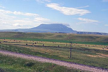
The land in Chouteau County is mostly rolling prairie. This is why a lot of wheat is grown here. But there are also some mountains. These are like "island ranges" in the middle of the flat land. The Bear Paw Mountains are in the northeast. The Little Rockies and Highwood Range are in the southeast. Important rivers flow through the county. These include the Teton River, Marias River, Missouri River, and Arrow Creek.
Neighboring Counties
- Liberty County – north
- Hill County – north
- Blaine County – east
- Fergus County – southeast
- Judith Basin County – south
- Cascade County – south
- Teton County – west
- Pondera County – northwest
Main Road
Protected Natural Areas
- Lewis and Clark National Forest (part of it)
- Upper Missouri River Breaks National Monument (part of it)
People of Chouteau County
| Historical population | |||
|---|---|---|---|
| Census | Pop. | %± | |
| 1870 | 517 | — | |
| 1880 | 3,068 | 493.4% | |
| 1890 | 4,741 | 54.5% | |
| 1900 | 10,966 | 131.3% | |
| 1910 | 17,191 | 56.8% | |
| 1920 | 11,051 | −35.7% | |
| 1930 | 8,635 | −21.9% | |
| 1940 | 7,316 | −15.3% | |
| 1950 | 6,974 | −4.7% | |
| 1960 | 7,348 | 5.4% | |
| 1970 | 6,473 | −11.9% | |
| 1980 | 6,092 | −5.9% | |
| 1990 | 5,452 | −10.5% | |
| 2000 | 5,970 | 9.5% | |
| 2010 | 5,813 | −2.6% | |
| 2020 | 5,895 | 1.4% | |
| 2022 (est.) | 5,898 | 1.5% | |
| U.S. Decennial Census 1790–1960 1900–1990 1990–2000 2010–2020 |
|||
Places Defined by Census
The United States Census Bureau also looks at smaller areas. These are called Census-designated places, or CDPs. They help gather information about rural areas. Here are some CDPs in Chouteau County:
- Boneau
- Carter
- Floweree
- Highwood
- Loma
- Parker School
- Rocky Boy West
- Square Butte
- Sunnybrook Colony
- Twin Hills Colony
2020 Population Count
In 2020, the census showed 5,895 people living in Chouteau County.
2010 Population Count
The 2010 census counted 5,813 people. There were 2,294 homes and 1,560 families. Most people were white (75.8%). A large group (21.8%) were American Indian. People from other backgrounds made up smaller parts of the population. Many people had German (27.6%) or Irish (13.0%) family roots.
About 31.2% of homes had children under 18. The average age of people in the county was 41.5 years old.
Economy of Chouteau County
Chouteau County is very important for farming. It grows the most winter wheat in Montana. It is part of an area called the "Golden Triangle." This area produces about 45% of all the wheat grown in Montana each year.
Towns and Communities
City
- Fort Benton (This is the county seat, where the main government offices are.)
Towns
Other Communities
These are smaller places that are not officially organized as cities or towns.
- Big Sag
- Coal Banks Landing
- Lippard
- Montague
- Shepherd Crossing
- Shonkin
- Stranahan
- Virgelle
- Warrick
- Woods Crossing
See also
 In Spanish: Condado de Chouteau para niños


