
Columbia Slough facts for kids
Quick facts for kids Columbia Slough |
|
|---|---|

Columbia Slough near mouth
|
|

Columbia Slough watershed
|
|

Location of the mouth of Columbia Slough in Oregon
|
|
| Country | United States |
| State | Oregon |
| County | Multnomah |
| Physical characteristics | |
| Main source | Fairview Lake (nominal) Fairview, Multnomah County, Oregon 10 ft (3.0 m) 45°33′00″N 122°27′24″W / 45.55000°N 122.45667°W |
| River mouth | Willamette River Portland, Multnomah County, Oregon 9 ft (2.7 m) 45°38′36″N 122°46′07″W / 45.64333°N 122.76861°W |
| Length | 19 mi (31 km) |
| Basin features | |
| Basin size | 51 sq mi (130 km2) |
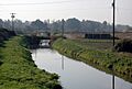
The Columbia Slough is a long, narrow waterway, about 19 miles (31 km) long, in the floodplain of the Columbia River in Oregon. It starts in Fairview and winds west through Gresham and Portland. It eventually flows into the Willamette River, close to where the Willamette joins the Columbia River.
This slough is what's left of old wetlands that used to be between the Sandy River and the Willamette River. Most of the slough and its smaller channels are surrounded by Levees. Workers use pumps and floodgates to control the water flow. The ocean's tides can even make the water flow backward in the lower part of the slough!
The land around the Columbia Slough was shaped by ancient lava flows, volcanoes, and huge floods called the Missoula Floods. About 158,000 people live in the slough's watershed, which is about 51 square miles (130 km2). This area is important for drinking water for Portland and nearby cities. Many groups work together to manage the slough, including cities, drainage districts, and regional governments.
Long ago, Native American tribes fished and hunted here. Later, explorers like Lewis and Clark visited. In the 19th century, settlers arrived, building farms, towns, and industries. Over time, floods caused a lot of damage, leading to more levees being built. A big flood in 1948 even destroyed the city of Vanport.
For many years, the slough was very dirty. But starting in the 1950s, people began working to clean it up. Laws like the Clean Water Act helped make things better. Today, the slough is much cleaner. It's home to over 150 kinds of birds and 26 types of fish, plus animals like otters, beaver, and coyotes. It's also a place for fun activities like boating, hiking, and biking.
Contents
What Does "Slough" Mean?
The word slough usually rhymes with shoe in the U.S. It can mean a muddy place, a swamp, or a small river channel in a marsh. The Columbia Slough is officially called a "stream" by the United States Geological Survey (USGS). It gets its name from the Columbia River, which it used to be a side channel of. The Columbia River was named by Robert Gray in 1792, after his ship, the Columbia Rediviva. The ship's name honored Christopher Columbus.
Where Does the Columbia Slough Flow?

The Columbia Slough flows mostly west, staying about 0.4 to 1.7 miles (0.6 to 2.7 km) south of the Columbia River. It starts at Fairview Lake in Fairview and quickly enters Gresham. After less than 1 mile (1.6 km), it reaches Portland. It then travels about 18 miles (29 km) more until it joins the Willamette River.
The slough is almost completely flat. It's only 10 feet (3.0 m) above sea level at its start and 9 feet (2.7 m) at its end. The ocean's tides cause the water to flow backward in the lower 8.5 miles (13.7 km) of the slough twice a day.
The slough passes by many interesting places:
- Zimmerman Heritage Farm
- Big Four Corners Wetlands
- Prison Pond Wetlands
- Portland International Airport
- Whitaker Ponds Natural Area
- Portland Meadows horse racing track
- Delta Park and Portland International Raceway
- Smith and Bybee Wetlands Natural Area
- Kelley Point Park
It finally flows into the Willamette River, which then joins the Columbia River about 1 mile (1.6 km) away. The Columbia River then flows another 101 miles (163 km) to the Pacific Ocean at Astoria.
How Much Water Flows?
Since 1989, the USGS has measured the slough's water flow near its mouth. On average, about 93.8 cubic feet per second (3 m3/s) of water flows through it. The most water ever recorded was 2,400 cubic feet per second (68 m3/s) in December 1995. The biggest reverse flow (when water flowed backward) was −6,700 cubic feet per second in February 1996, during a big flood on the Columbia and Willamette rivers.
.jpg)
Understanding the Slough's Watershed
The Columbia Slough watershed covers about 51 square miles (130 km2). A watershed is an area of land where all the water drains into a single river or body of water. This watershed is located in the floodplain of the Columbia River. It includes parts of Portland, Fairview, Gresham, and other nearby areas. In 2005, about 158,000 people lived here.
The watershed is a mix of many things:
- Homes and neighborhoods
- Farms
- The airport
- Parks and open spaces
- Schools
- Highways and railways
- Businesses and industries
About 57,000 people work in the businesses and industries found in the watershed.
Who Manages the Slough?
Many different groups work together to manage the Columbia Slough and its watershed. These include:
- The cities of Portland, Fairview, Gresham, Maywood Park, and Wood Village.
- Multnomah County government.
- Metro, a regional government agency that helps protect wildlife areas and build trails.
- The Oregon Department of Environmental Quality (DEQ), which sets rules for water quality.
- The Port of Portland, which owns a lot of land in the watershed.
- Three drainage districts that control water flow and flooding.
How Healthy is the Slough?
Since 2015, Portland's Bureau of Environmental Services (BES) gives the slough a "report card" each year. They grade it on four things:
- Hydrology: How water moves through the area.
- Water Quality: How clean the water is.
- Habitat: How good the area is for plants and animals.
- Fish and Wildlife: How many different kinds of animals live there.
In 2015, the slough got B− for hydrology and water quality, D− for habitat, and F for fish and wildlife. This shows there's still work to do to make the slough even healthier.
The Slough's Geological Story

The Columbia Slough is part of the large Portland Basin. This area sits on top of very old, hardened lava from volcanoes that erupted millions of years ago. Over time, mud, ash, and volcanic rock flowed into the Columbia River, adding layers of sediment. This created an aquifer, which is an underground layer of rock that holds water. This aquifer is a main source of drinking water for Vancouver and an extra source for Portland.
About 3 million years ago, many small volcanoes erupted in the area, adding more layers of ash and cinders. Then, about 15,000 years ago, huge ice age floods called the Missoula Floods swept through the Columbia River basin many times. These floods were so powerful they filled the entire Columbia Gorge and turned the Willamette Valley into a giant lake! They also left behind huge amounts of gravel and sediment, like Alameda Ridge in Portland.
The Portland Basin is slowly pulling apart due to faults in the earth. These faults can cause earthquakes. Many small earthquakes have been recorded here, and some stronger ones have shaken the area, like one in 1962.
How Water Moves in the Slough
Portland International Airport gets about 36 inches (910 mm) of rain each year. Most of this rain falls in the winter. In the past, plants and wetlands soaked up most of the rain. But now, with so many buildings, roads, and runways, more than half of the watershed is covered in hard surfaces. This means rainwater flows into the slough much faster than it used to.
Controlling Water Flow
Before the 1900s, the slough was part of the Columbia River's natural floodplain. When the Columbia River was high, water would flow into the slough. But in 1917, landowners created drainage districts to control flooding. They built 30 miles (48 km) of levees, along with pumps and floodgates.
- Upper Slough: This part is managed by the Multnomah County Drainage District (MCDD). They can close gates and pump water directly into the Columbia River if there's too much water.
- Middle Slough: Also managed by MCDD, this section has many side channels and small lakes. Pumps can move water from here to the lower slough.
- Lower Slough: Water levels here are mostly affected by the Willamette River's tides. The flow direction changes with the tide. This area is managed by two other drainage districts.
Creeks and Lakes

Fairview Lake, where the slough starts, was created in 1960 for water storage and recreation. Fairview Creek flows into this lake. Wilkes Creek is the only other natural stream that still flows into the slough. Many other small streams that used to flow into the slough have been put into pipes or filled in.
The slough's watershed has many other bodies of water:
- Buffalo Slough
- Whitaker Slough
- Johnson Lake
- Whitaker Ponds
- Prison Pond
- Smith and Bybee Wetlands Natural Area: This is one of the largest urban freshwater wetlands in the United States, covering about 2,000 acres (810 ha).
Underground Water Sources
Underground water, called aquifers, also feeds the slough. The City of Portland has a well field that taps into deeper aquifers. These wells can provide a lot of water, up to 100 million US gallons (380,000 m3) a day, to help supply the city with drinking water during dry times or emergencies.
A Look at the Slough's History

Native Americans lived along the lower Columbia River for thousands of years. The Clackamas Indians, part of the Chinookan tribes, lived along the Clackamas River and the lower Willamette River. They used the slough for fishing and hunting, traveling between the big rivers. Salmon, sturgeon, and camas plants were important foods for them.
In 1792, British explorer Lieutenant William Broughton explored the Columbia River. He met many Chinookan people. Later, in 1806, Lewis and Clark visited the area. Sadly, by the 1830s, diseases brought by explorers and traders greatly reduced the native population. In 1855, the Clackamas tribe signed a treaty, giving up their lands to the U.S.
Settlers and Industry

In the mid-1800s, White settlers began to claim land in the Columbia Slough watershed. They cut timber, built sawmills, fished, and farmed. The slough was used to ship timber to Portland. The community of St. Johns was founded in 1852. As Portland grew, it expanded into the slough area.
In the early 1900s, many businesses, like meatpacking plants and slaughterhouses, opened along the slough. They often put their waste into the water. Starting in 1910, sewage from homes in north Portland also flowed into the slough. This made the slough very dirty. People tried to clean it, but it was difficult because the tides kept bringing water back in.
World War II and the Vanport Flood

During World War II, Kaiser Shipbuilding Company built many ships near the lower slough. To house the thousands of shipyard workers, a new city called Vanport was built in 1942. It was surrounded by high dikes to protect it from floods. By 1943, Vanport was the second-largest city in Oregon.
On May 30, 1948, a flood broke through Vanport's western levee. The water slowly filled the city, allowing most residents to escape. However, the flood completely destroyed Vanport, and it was never rebuilt. This disaster led to stronger levees being built around the slough. The flood also caused the Vanport Extension Center, a college, to move to downtown Portland, where it eventually became Portland State University.

After the war, there was a lot of discussion about how to use the slough. Some wanted more industry, while others wanted to clean it up. In 1978, the U.S. Congress removed the slough's "navigable" status, which meant it could no longer be dredged for large ships. This opened the door for more recreation. New laws like the federal Clean Water Act also helped push for cleanup efforts.
Cleaning Up the Slough
For many years, the Columbia Slough was very polluted. Raw sewage and waste from industries flowed directly into it. In 1952, Portland built its first sewage treatment plant near the lower slough. This plant helped clean the water before it went into the Columbia River. However, during heavy rains, some untreated water still entered the slough.
In 1991, the St. Johns Landfill, next to the lower slough, was closed. In 1994, the city began a big cleanup project for the slough. The United States Environmental Protection Agency (EPA) even gave a $10 million grant to help.
Studies in the 1980s and 1990s showed the Columbia Slough had some of the worst water quality in the lower Willamette basin. It had high levels of certain chemicals and bacteria. However, by 2000, the city had spent about $200 million to stop untreated sewage from entering the slough. They also replaced old septic systems with modern sewers.
By 2002, water quality had greatly improved. While the slough is much cleaner now, it's still not safe to eat fish or crayfish from it because they can contain harmful chemicals. Efforts continue to make the slough even healthier for everyone.
Animals and Plants of the Slough

Over the years, development has changed the natural homes for plants and animals in the watershed. In 1851, almost all the watershed was natural habitat. By 2003, only about a third of it was still habitat, and much of that was affected by roads and invasive plants like Himalayan blackberry.
However, many groups are working to improve the habitat. They are planting native trees and shrubs, removing invasive weeds, and connecting different natural areas.
Who Lives in the Slough?
Even with the changes, the slough watershed is home to a wide variety of wildlife. Many species that lived here in 1850 still do!
- Birds: Over 150 species, including Bald eagles and great blue herons. Many ducks, geese, and other migrating birds visit.
- Fish: 26 species, with 12 native ones. Young salmon and Coastal cutthroat trout use the slough and its creeks.
- Mammals: Beaver, muskrat, river otter, black-tailed deer, and coyotes.
- Other Animals: Several kinds of amphibians, western pond turtles, and freshwater mussels.
Some non-native animals have also adapted to the slough, like the nutria, common carp, and bullfrog.
Plants of the Slough
The slough watershed has many different plants. You can find:
In some places, water plants like wapato and Columbia sedge grow. Golf courses and developed areas often have non-native grasses and trees. Invasive plants like Himalayan blackberry and English ivy are also common.
Fun Things to Do at the Slough
The Columbia Slough offers many ways to enjoy nature and get active!
Parks and Wetlands to Explore
- Lakeshore Park: At the start of the slough in Fairview.
- Blue Lake Regional Park: A large park with a lake, great for recreation.
- Chinook Landing Marine Park: Oregon's biggest public boating park on the Columbia River.
- Big Four Corners Wetlands: A large natural area with wetlands and forests, home to deer, coyotes, and otters.
- Johnson Lake: A natural area where groups are working to improve the habitat.
- Whitaker Ponds Nature Park: A 25-acre (10 ha) site with walking trails, a canoe launch, and a garden.
- Columbia Children's Arboretum: A park with every U.S. state tree.
- Delta Park: A big park complex with sports fields, the Portland International Raceway, and the Heron Lakes Golf Course.
- Smith and Bybee Wetlands Natural Area: One of the largest urban freshwater wetlands in the U.S., perfect for nature watching.
- Kelley Point Park: Located at the very tip of the peninsula where the Willamette and Columbia rivers meet.
Trails for Hiking and Biking

The 40-Mile Loop is a big trail system that goes around and through Portland. Parts of it run along the Columbia Slough watershed. There are also other trails that cross or follow the slough:
- Columbia Slough Trail: An east-west trail that runs along the slough.
- Gresham-Fairview Trail: A planned north-south route connecting to the 40-Mile Loop.
- Peninsula Crossing Trail: A 3-mile (4.8 km) trail that crosses the lower slough and is great for hiking and biking. It's flat and wheelchair accessible.
Boating Adventures
The slough is a great place for canoeing and kayaking because the water is mostly flat. You can paddle almost the entire 19 miles (31 km) length of the slough, but you'll need to carry your boat around some levees and obstacles. A full trip can take at least nine hours.
For the lower 8.5 miles (13.7 km) of the slough, it's best to plan your trip with the tides so you can paddle with the current. There are eight places to launch your boat along the slough, from Fairview Lake at the beginning to Kelley Point Park near the end.
Images for kids
-
Upper slough just below Fairview Lake

