Custer County, Idaho facts for kids
Quick facts for kids
Custer County
|
||
|---|---|---|
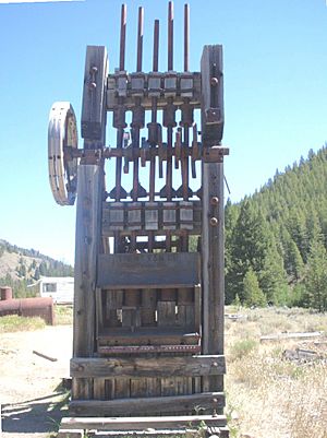
Mill used to process gold and silver ore at Yankee Fork mining operations.
|
||
|
||
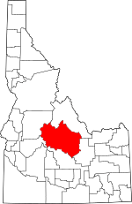
Location within the U.S. state of Idaho
|
||
 Idaho's location within the U.S. |
||
| Country | ||
| State | ||
| Founded | January 8, 1881 | |
| Named for | General Custer gold mine | |
| Seat | Challis | |
| Largest city | Challis | |
| Area | ||
| • Total | 4,937 sq mi (12,790 km2) | |
| • Land | 4,921 sq mi (12,750 km2) | |
| • Water | 16 sq mi (40 km2) 0.3% | |
| Population
(2020)
|
||
| • Total | 4,249 |
|
| • Density | 0.88/sq mi (0.34/km2) | |
| Time zone | UTC−7 (Mountain) | |
| • Summer (DST) | UTC−6 (MDT) | |
| Congressional district | 2nd | |
Custer County is a mountain county located right in the middle of Idaho, a state in the United States. In 2020, about 4,275 people lived here, making it one of the least populated counties in Idaho. The main town and county seat is Challis. Custer County was created in 1881. It got its name from the General Custer Mine, where people found gold five years earlier. Today, Custer County's main activities are ranching, mining, and tourism.
Contents
Geography of Custer County
Custer County is very large, covering about 4,937 square miles. Most of this area is land, with only a small part being water. It is the third-largest county in Idaho by size.
Mountains and Rivers
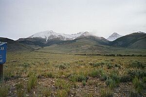
Custer County is home to some of Idaho's tallest mountains.
- The Lost River Range is in the eastern part of the county. Here you'll find Borah Peak, which is the highest point in all of Idaho, standing at 12,662 feet.
- On the western side is the famous Sawtooth Range. Its tallest peak in Custer County is Thompson Peak, which overlooks the beautiful Redfish Lake.
- The White Cloud Mountains are also in the east, with Castle Peak reaching 11,815 feet.
Two important rivers flow through Custer County: the Salmon River and the Big Lost River.
Neighboring Counties
Custer County shares its borders with several other counties:
- Lemhi County to the north
- Butte County to the east
- Blaine County to the south
- Elmore County to the southwest
- Boise County to the southwest
- Valley County to the west
Main Roads
These are the major highways that help people travel through Custer County:
Protected Natural Areas
A lot of Custer County's land is part of national protected areas, which means these places are kept safe for nature and recreation:
- Challis National Forest (part)
- Sawtooth National Forest (part)
- Sawtooth National Recreation Area (part)
- Hemingway–Boulders Wilderness (part)
- Jim McClure–Jerry Peak Wilderness
- Sawtooth Wilderness (part)
- Cecil D. Andrus–White Clouds Wilderness
People of Custer County
| Historical population | |||
|---|---|---|---|
| Census | Pop. | %± | |
| 1890 | 1,870 | — | |
| 1900 | 2,049 | 9.6% | |
| 1910 | 3,001 | 46.5% | |
| 1920 | 3,550 | 18.3% | |
| 1930 | 3,162 | −10.9% | |
| 1940 | 3,549 | 12.2% | |
| 1950 | 3,318 | −6.5% | |
| 1960 | 2,996 | −9.7% | |
| 1970 | 2,967 | −1.0% | |
| 1980 | 3,385 | 14.1% | |
| 1990 | 4,133 | 22.1% | |
| 2000 | 4,342 | 5.1% | |
| 2010 | 4,368 | 0.6% | |
| 2020 | 4,275 | −2.1% | |
| 2023 (est.) | 4,523 | 3.5% | |
| U.S. Decennial Census 1790–1960 1900–1990 1990–2000 2010–2020 |
|||
In 2010, there were 4,368 people living in Custer County. Most of the people (about 96.4%) were white. About 4% of the population was of Hispanic or Latino background. The average age of people living in Custer County was 48 years old.
Towns and Settlements
Cities in Custer County
Smaller Communities
These are places that are not officially cities:
- Dickey
- Ellis
- Goldburg
Ghost Towns
Custer County also has some interesting ghost towns, which are old towns that are now mostly empty:
Education
Children in Custer County attend schools in these districts:
- Butte County Joint School District 111
- Challis Joint School District 181
- Mackay Joint School District 182
While College of Eastern Idaho serves this county, residents here do not pay taxes to support it.
See also
 In Spanish: Condado de Custer (Idaho) para niños
 | DeHart Hubbard |
 | Wilma Rudolph |
 | Jesse Owens |
 | Jackie Joyner-Kersee |
 | Major Taylor |


