Diekirch (district) facts for kids
Quick facts for kids Diekirch |
|
| District | |
| Country | |
|---|---|
| Capital | Diekirch |
| - coordinates | 49°52′N 6°10′E / 49.867°N 6.167°E |
| Area | 1,157.2 km² (447 sq mi) |
| Population | 83,661 (2014) |
| Density | 72 /km² (186 /sq mi) |
| District | 24 February 1843 |
| Subdivisions | 5 cantons 36 communes |
| Timezone | CET (UTC+1) |
| - summer (DST) | CEST (UTC+2) |
| ISO 3166-2 | LU-D |
The District of Diekirch (called Diekirch in French and German, and Dikrech in Luxembourgish) was one of the three main regions of Luxembourg. Its main city was also called Diekirch.
In 2015, these districts were officially ended.
Diekirch was the northernmost and largest of the three districts. It covered an area of about 1,157 square kilometers (447 square miles). In 2014, about 83,661 people lived there. This made it the least crowded district in Luxembourg.
Contents
A Look Back: History
The Diekirch District was created on February 24, 1843. It was one of the first three districts in the country.
Over time, some changes happened to the smaller areas within the district. In 2012, several communes (like small towns or local areas) were combined. For example, Heinerscheid and Munshause joined to form Clervaux. Hosingen, Consthum, and Hoscheid became the new commune of Parc Hosingen. Ermsdorf and Medernach merged to create Vallée de l'Ernz. Also, Heiderscheid and Neunhausen joined Esch-sur-Sûre. These changes reduced the number of communes from 43 to 36.
Where Was It? Geography
The Diekirch District was located in a special spot. To its west and north, it shared borders with Belgium. Specifically, it touched the Belgian provinces of Luxembourg and Liège. To the east, it bordered Germany, specifically the region of Rhineland-Palatinate.
To the south, it was next to the Luxembourg District. To the southwest, it bordered the Grevenmacher District.
This district was home to the two highest hills in all of Luxembourg. These are the Kneiff, which is 560 meters (1,837 feet) tall, and Buurgplaatz, which is 559 meters (1,834 feet) tall. Both of these hills are found in the commune of Troisvierges.
Most of the former Diekirch District is part of a region called Oesling.
How It Was Organized: Cantons and Communes
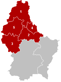
The Diekirch District was divided into 5 larger areas called cantons. These cantons then contained a total of 36 smaller local areas called communes.
| Canton | Capital | Area (km²) |
Population (2014) |
Density (inhab./km²) |
Communes | |
|---|---|---|---|---|---|---|
| 1 | Clervaux | Clervaux | 342.2 | 16,447 | 48.1 | 5 |
| 2 | Diekirch | Diekirch | 204.5 | 30,460 | 148.9 | 10 |
| 3 | Redange | Redange | 267.5 | 17,086 | 63.9 | 10 |
| 4 | Vianden | Vianden | 78.5 | 4,722 | 60.2 | 3 |
| 5 | Wiltz | Wiltz | 264.6 | 14,946 | 56.5 | 8 |
Cantons and Their Communes
Here are the five cantons that made up the Diekirch District, along with the communes found in each:
See also
 In Spanish: Distrito de Diekirch para niños
 | George Robert Carruthers |
 | Patricia Bath |
 | Jan Ernst Matzeliger |
 | Alexander Miles |


