
Lexington, Massachusetts facts for kids
Quick facts for kids
Lexington, Massachusetts
|
|||
|---|---|---|---|

The Lexington Minuteman statue in Lexington
|
|||
|
|||
| Etymology: Likely from Laxton, Nottinghamshire | |||
| Nickname(s):
Birthplace of American Liberty
|
|||
| Motto(s):
"What a Glorious Morning for America!"
|
|||

Location in Middlesex County in Massachusetts
|
|||
| Lua error in Module:Location_map at line 416: Malformed coordinates value. | |||
| Country | |||
| State | |||
| County | Middlesex | ||
| Region | New England | ||
| Settled | 1642 | ||
| Incorporated | 1713 | ||
| Government | |||
| • Type | Representative town meeting | ||
| Area | |||
| • Total | 16.5 sq mi (42.8 km2) | ||
| • Land | 16.4 sq mi (42.5 km2) | ||
| • Water | 0.1 sq mi (0.4 km2) | ||
| Elevation | 210 ft (64 m) | ||
| Population
(2020)
|
|||
| • Total | 34,454 | ||
| • Density | 2,088/sq mi (805.0/km2) | ||
| Demonym(s) | Lexingtonian | ||
| Time zone | UTC−5 (Eastern) | ||
| • Summer (DST) | UTC−4 (Eastern) | ||
| ZIP Codes |
02420–02421
|
||
| Area code(s) | 339/781 | ||
| FIPS code | 25-35215 | ||
| GNIS feature ID | 0619401 | ||
| Website | www.lexingtonma.gov | ||


Lexington is a town in Middlesex County, Massachusetts, United States. It's a suburban area located about 10 miles (16 km) from Downtown Boston. In 2020, about 34,454 people lived there.
Native Americans first lived in this area. European settlers arrived around 1642, starting a farming community. Lexington is famous for being where the first shots of the American Revolutionary War were fired. This happened during the Battle of Lexington on April 19, 1775. This event is often called the "Shot heard 'round the world." The town is also home to Minute Man National Historical Park.
Contents
History of Lexington

Early Inhabitants and Settlement
For thousands of years, Native Americans lived in the area that is now Lexington. An old archaeological site near Loring Hill shows this. When Europeans first arrived, the land was likely a border area between different Native American groups.
European diseases greatly reduced the native population. This made it easier for English settlers to arrive in the 1600s. In 1639, the Massachusetts General Court bought the land from the Naumkeag tribe. At that time, Lexington was part of Cambridge, Massachusetts.
Becoming a Town
Around 1642, the area was first settled by Europeans. As more people moved in, Lexington became a separate church parish in 1691. It was called Cambridge Farms. This meant residents could have their own church and minister. However, they were still part of Cambridge.
Lexington officially became a separate town in 1713. This is when it got its current name. There are two main ideas about how it got the name. One idea is that it was named after Lord Lexington, an English nobleman. Another idea is that it was named after a town in England called Lexington (now spelled Laxton).
In early colonial times, Vine Brook was very important. This brook runs through Lexington and nearby towns. It provided water for mills and for farming.
The Battle of Lexington

On April 19, 1775, the Battle of Lexington took place. Many people consider this the first battle of the American Revolutionary War.
The night before, about 800 British soldiers marched from Boston. Their goal was to destroy American gunpowder and cannons stored in Concord. They also wanted to capture John Hancock and Samuel Adams, two important leaders, who were in Lexington.
Paul Revere and William Dawes rode to warn people about the British. When the British arrived at the Lexington Common at sunrise, they met 77 local militia members. These men were led by Captain John Parker.
Someone fired a shot, and then both sides started shooting. Eight Lexington militia members were killed, and many more were hurt. After this, the British marched to Concord. There, more American militia members gathered to stop the British.
Today, Lexington remembers this battle every year. A reenactment takes place on the Battle Green as part of the Patriots' Day celebrations.
Growth and Modernization
For many years after the Revolutionary War, Lexington remained a farming community. It supplied Boston with food. By the 1970s, many farms became new housing areas. One famous neighborhood, Peacock Farm, was designed by architect Walter Pierce and built between 1952 and 1958. It is now on the National Register of Historic Places.
Lexington has always had a busy downtown area, which is still active today. The town grew because it was close to Boston and had a train line. The train service started in 1846 and ended in 1981.
In the 1960s and 1970s, Lexington's population grew a lot. This was due to the rise of high-tech companies. Today, many companies, like Takeda and BAE Systems, have large offices in Lexington. This growth has led to high property values and an excellent school system.
Lexington also takes part in the METCO program. This program helps minority students from Boston attend schools in suburban towns like Lexington. This gives them better educational chances.
Geography of Lexington
Lexington is located at 42°26′39″N 71°13′36″W. The town covers about 16.5 square miles (42.8 km²). Most of this area is land, with a small amount of water.
Lexington shares its borders with several other towns. These include Burlington, Woburn, Winchester, Arlington, Belmont, Waltham, Lincoln, and Bedford. Lexington is larger than all of its neighboring towns.
Population and People
Lexington has grown steadily over the years. In 2010, there were 31,394 people living in the town. By 2020, the population had grown to 34,454.
The town is home to a diverse population. In 2010, about 68.6% of residents were White, and 25.4% were Asian. A smaller percentage were Black or African American, Native American, or from other racial backgrounds. About 2.3% of the population identified as Hispanic or Latino.
In 2022, Lexington had the highest Asian population in Massachusetts, making up 32% of all residents. Also, 33% of people living in Lexington were born outside the United States. This diversity is also seen in the Lexington Public Schools, where over 45% of students are Asian.
Transportation in Lexington
MBTA bus services connect Lexington to the Red Line subway at Alewife station in Cambridge. Lexington also has its own bus service called Lexpress. This service operates three routes on weekdays, with buses ending at Depot Square.
Emergency Services
Law Enforcement
The Lexington Police Department (LPD) is in charge of keeping the town safe. They handle investigations, patrols, and traffic safety. The department has 51 police officers. They also offer a youth academy for kids aged 12–17 and a Police Explorers Program for high school students interested in law enforcement. The Chief of Police is Michael McLean.
Fire and Rescue
The Lexington Fire Department (LFD) provides fire, rescue, and emergency medical services. The department has 61 firefighters and EMS personnel. They operate from the Fire Department Headquarters and a secondary East Lexington Station. Derek Sencabaugh is the Fire Chief.
Education in Lexington
Public Schools
Lexington has a strong public education system. It includes six elementary schools, two middle schools, and one high school. Students can choose to attend Minuteman Regional High School or the local Lexington High School.
Lexington High School has won the U.S. Department of Energy (DOE) National Science Bowl competition multiple times (in 2012, 2017, 2018, 2023, and 2024). Jonas Clarke Middle School also won the National Middle School Science Bowl competition in 2019 and 2021.
- Elementary Schools
- Joseph Estabrook Elementary School
- Fiske Elementary School
- Maria Hastings Elementary School
- Bridge Elementary School
- Bowman Elementary School
- Harrington Elementary School
- Middle Schools
- William Diamond Middle School
- Jonas Clarke Middle School
- High Schools
- Lexington High School
- Minuteman Regional High School
Private Schools
- Lexington Christian Academy
- Lexington Montessori School
- The Waldorf School of Lexington
Extra Learning Programs
- The Lexington Chinese School (LCS) holds classes at Belmont High School in Belmont. In 2003, over 400 students attended Sunday classes at LCS.
- Shishu Bharati School of Languages and Culture of India teaches about Indian languages and culture.
- AOPS Academy has a branch in Lexington that teaches math and language arts.
Culture and Art


Music Scene
Lexington is home to the Lexington Symphony. This orchestra performs regularly at Cary Hall, offering classical music concerts.
Economy and Jobs
Lexington has several major employers. These include large companies like Takeda (a pharmaceutical company) and BAE Systems (a defense company). Other important employers are MIT Lincoln Laboratory, Novo Nordisk, Agilent, and Global Insight. Local businesses like CareOne and Ipswitch also provide many jobs. The Lexington Public Schools system is also a significant employer.
Places to Visit
Lexington is well known for its history. It has many historic buildings, parks, and monuments. Most of these date back to the Colonial and Revolutionary periods.
- The Lexington Common, also called the Battle Green, is a very important historical spot. It's where the "shot heard round the world" was fired during the Battle of Lexington. A statue of Captain John Parker, who led the Lexington Militia, stands on the Green. Locals call it the Minuteman Statue. Every year on Patriots' Day, a reenactment of the battle takes place here.
- The Revolutionary Monument is the oldest standing war memorial in the United States. It was finished on July 4, 1799. It is also the gravesite of the colonists who died in the Battle of Lexington.
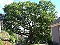
- Other historical places include the Old Burying Ground (with gravestones from 1690), the Old Belfry, Buckman Tavern (built around 1704–1710), Munroe Tavern (around 1695), and the Hancock-Clarke House (1737). You can also see the U.S.S. Lexington Memorial and the Centre Depot, which used to be a train station. The Follen Church (built in 1839) is the oldest church building in Lexington. The Mulliken White Oak is one of Lexington's oldest and most famous trees.
- Lexington is also home to part of the Minute Man National Historical Park. This park covers about 900 acres (3.6 km²) and stretches into neighboring towns like Lincoln and Concord.
- The Scottish Rite Masonic Museum & Library has exhibits about American history and Freemasonry.
- Lexington's town center has many restaurants, art galleries, shops, a small cinema, and the Cary Memorial Library. The Minuteman Bikeway also runs through here.
- The Great Meadow, also known as Arlington's Great Meadows, is a large meadow and marshland in East Lexington. It is owned by the town of Arlington.
- Willards Woods Conservation Area is a small forest of protected land.
- Wilson Farm is a farm and farm stand that has been operating since 1884.
- The Lexington Community Center is a place for residents to meet and gather.
- The "Old Reservoir," or "The Res," used to provide drinking water. Now, it's a place for swimming and picnics in summer. In winter, when it freezes, people use it for ice skating.
- Lexington has several important modernist neighborhoods. These include Six Moon Hill, Peacock Farm, Five Fields, and Turning Mill/Middle Ridge.
Famous People from Lexington
To learn about famous people who have lived in Lexington, see the main article: List of people from Lexington.
Sister Cities
Lexington has "sister city" relationships with other towns around the world. These partnerships help promote cultural exchange and understanding. Lexington's sister cities are:
Images for kids
-

Aerial view of Lexington, December 1935
-
Historic Mullikan Oak Tree, September 2012
.jpg)

See also
 In Spanish: Lexington (Massachusetts) para niños
