
Enfield, New Hampshire facts for kids
Quick facts for kids
Enfield, New Hampshire
|
||
|---|---|---|
|
Town
|
||

Main Street in Enfield, 2016
|
||
|
||

Location in Grafton County, New Hampshire
|
||
| Country | United States | |
| State | New Hampshire | |
| County | Grafton | |
| Incorporated | 1761 | |
| Villages |
|
|
| Area | ||
| • Total | 43.2 sq mi (111.8 km2) | |
| • Land | 40.3 sq mi (104.4 km2) | |
| • Water | 2.9 sq mi (7.4 km2) | |
| Elevation | 778 ft (237 m) | |
| Population
(2020)
|
||
| • Total | 4,465 | |
| • Density | 111/sq mi (42.8/km2) | |
| Time zone | UTC-5 (Eastern) | |
| • Summer (DST) | UTC-4 (Eastern) | |
| ZIP code |
03748
|
|
| Area code(s) | 603 | |
| FIPS code | 33-24340 | |
| GNIS feature ID | 0873590 | |

Enfield is a friendly town in Grafton County, New Hampshire, United States. In 2020, about 4,465 people lived here. The town includes several small villages like Enfield, Enfield Center, Upper Shaker Village, Lower Shaker Village, Lockehaven, and Montcalm.
The main part of Enfield town is called the Enfield census-designated place (CDP). About 1,571 people lived here in 2020. It's located around U.S. Route 4 and where the Mascoma River flows into Mascoma Lake.
Contents
Town History
The town of Enfield was officially started in 1761 by the colonial Governor Benning Wentworth. It was first named "Enfield" by settlers who came from Enfield, Connecticut.
Name Changes
In 1766, the town's name was changed to "Relhan." This was to honor Dr. Anthony Relhan, who helped make Brighton, England, a popular place for sea-bathing. After the American Revolution, the town was renamed Enfield again in 1784.
First Settlers
The first European settlers in Enfield were Jonathan Paddleford and his family. They arrived between 1765 and 1772, after the French and Indian War had ended.
The Shakers of Enfield
On the southwest side of Mascoma Lake, you'll find the Enfield Shaker Village. This was once a special religious community of Shakers. They were known for their simple and useful buildings and furniture.
The Shaker village started in 1793 and was called "Chosen Vale." It was divided into different "Families." Men and women lived very religious, celibate (meaning they didn't marry or have children), and hardworking lives. Even though they shared dormitories, like the Great Stone Dwelling built from 1837 to 1841, men and women used separate doors and stairways.
The Shakers expressed their worship through energetic singing and dancing. This is how they got the name "Shaking Quakers" or "Shakers."
Shaker Trades and Decline
The Shaker village was busy with many different jobs. They farmed, packaged seeds, and made things like brooms, brushes, spinning-wheels, and furniture. To help deliver their products faster, they built the Shaker Bridge across Mascoma Lake in 1849.
The Shaker movement was at its strongest in the 1840s. They had 19 communities from Maine to Kentucky. However, new job opportunities appeared during the Industrial Revolution, especially in nearby places like Lebanon. This caused some people to leave the Shaker communities. Others didn't like the celibacy or sharing all their property.
Eventually, the Enfield Shaker village closed. In 1927, it was sold to the La Salette Brotherhood, a Catholic group. In 1986, the Enfield Shaker Village became a museum. The museum has grown over the years, buying more of the historic Shaker buildings and land. In September 2023, they bought all the remaining buildings and land when the Catholic group left Enfield.
Town Geography
Enfield covers a total area of about 111.8 square kilometers (about 43.2 square miles). Most of this is land (104.4 square kilometers or 40.3 square miles), and 7.4 square kilometers (2.9 square miles) is water.
Waterways and Hills
The Mascoma River flows through Enfield. It eventually joins the Connecticut River. Mascoma Lake is in the western part of town and is the lowest point in Enfield, about 229 meters (751 feet) above sea level. The highest point is the top of Prospect Hill, which is over 640 meters (2,100 feet) high. Crystal Lake is in the eastern part of town. All the water in Enfield flows into the Connecticut River watershed.
Roads and Transportation
Enfield is served by major roads that help people travel through and to the town. These include Interstate 89, U.S. Route 4, New Hampshire Route 4A, and New Hampshire Route 10.
Population Information
| Historical population | |||
|---|---|---|---|
| Census | Pop. | %± | |
| 1790 | 724 | — | |
| 1800 | 1,121 | 54.8% | |
| 1810 | 1,291 | 15.2% | |
| 1820 | 1,370 | 6.1% | |
| 1830 | 1,492 | 8.9% | |
| 1840 | 1,514 | 1.5% | |
| 1850 | 1,742 | 15.1% | |
| 1860 | 1,876 | 7.7% | |
| 1870 | 1,662 | −11.4% | |
| 1880 | 1,680 | 1.1% | |
| 1890 | 1,439 | −14.3% | |
| 1900 | 1,845 | 28.2% | |
| 1910 | 1,448 | −21.5% | |
| 1920 | 1,577 | 8.9% | |
| 1930 | 1,325 | −16.0% | |
| 1940 | 1,693 | 27.8% | |
| 1950 | 1,612 | −4.8% | |
| 1960 | 1,867 | 15.8% | |
| 1970 | 2,345 | 25.6% | |
| 1980 | 3,175 | 35.4% | |
| 1990 | 3,979 | 25.3% | |
| 2000 | 4,618 | 16.1% | |
| 2010 | 4,582 | −0.8% | |
| 2020 | 4,465 | −2.6% | |
| U.S. Decennial Census | |||
In 2010, there were 4,582 people living in Enfield. There were 2,044 households, and 1,305 families. The town had about 43.9 people per square kilometer (113.7 people per square mile).
About 19.4% of the population was under 18 years old. The median age was 43.6 years. This means half the people were older than 43.6 and half were younger.
Places to Visit
- Enfield Shaker Museum
- Shaker Historic Trail, Enfield
- Lockhaven Schoolhouse Museum
Famous People from Enfield
- Robert O. Blood (1887–1975), a doctor and the 65th governor of New Hampshire.
- Jacob Cochran (1782–1836), a preacher.
- Wolfgang Köhler (1887–1967), a German psychologist.
- Frederick Ferdinand Moore (1881–1947), a writer, editor, and soldier.
- William Goodhue Perley (1820–1890), a businessman and member of the House of Commons of Canada.
- Stan Williams (1936–2021), a baseball pitcher who played for six MLB teams.
Images for kids
-
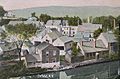
Enfield c. 1908
-
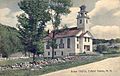
Centre Village Meeting House in 1909
-
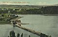
Shaker Bridge in 1908
-
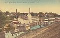
Baltic Mills in 1908


See also
 In Spanish: Enfield (Nuevo Hampshire) para niños
