Escambia County, Florida facts for kids
Quick facts for kids
Escambia County
|
||
|---|---|---|

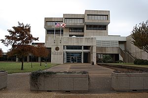
Escambia County Courthouse
|
||
|
||

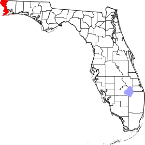
Location within the U.S. state of Florida
|
||
 Florida's location within the U.S. |
||
| Country | ||
| State | ||
| Founded | July 21, 1821 | |
| Named for | Escambia River | |
| Seat | Pensacola | |
| Largest city | Pensacola | |
| Area | ||
| • Total | 875 sq mi (2,270 km2) | |
| • Land | 656 sq mi (1,700 km2) | |
| • Water | 218 sq mi (560 km2) 25.0%% | |
| Population
(2020)
|
||
| • Total | 321,905 | |
| • Estimate
(2023)
|
326,928 |
|
| • Density | 367.89/sq mi (142.04/km2) | |
| Time zone | UTC−6 (Central) | |
| • Summer (DST) | UTC−5 (CDT) | |
| Congressional district | 1st | |
| Website | http://myescambia.com | |
Escambia County is the westernmost and oldest county in the U.S. state of Florida. It is located in the Northwest Florida region. In 2020, about 321,905 people lived here. The main city and county seat is Pensacola. Escambia County is part of the larger Pensacola Metropolitan Statistical Area. The number of people living in the county has been growing steadily. This is because Pensacola and its nearby towns are developing with new homes and businesses.
Contents
History of Escambia County
For thousands of years, different groups of Native Americans lived in this area. When Europeans first arrived, the main tribes were the Pensacola and Muscogee, also known as the Creek.
Escambia County was first settled by the Spanish. The United States took control of the area in 1818. The county was officially formed by European-Americans on July 21, 1821. It was named after the Escambia River. The name "Escambia" might come from the Creek word Shambia, which means "clear water." It could also come from a Choctaw word meaning "cane-brake" or "reed-brake." The Choctaw were another important tribe in the Southeast.
Escambia and St. Johns Counties were Florida's first two counties. They were created on the same day. Together, they covered all the land that is now Florida. The Suwannee River was the border between them. Escambia County covered the "panhandle" and "big bend areas. St. Johns County covered the rest of the state.
As more people moved to Florida, 21 other counties were later formed from Escambia County. This happened either directly or indirectly. Some of these counties include Jackson (1821), Walton (1824), Santa Rosa (1842), and Bay (1913). Since 1925, Florida has had 67 counties, and this number has stayed the same.
Geography of Escambia County
The U.S. Census Bureau says Escambia County covers about 875 square miles. About 656 square miles of this is land. The remaining 218 square miles, or 25%, is water.
The county also includes Santa Rosa Island, which is south of Pensacola. This island is not part of Santa Rosa County. Escambia County is part of the Pensacola-Ferry Pass-Brent Metropolitan Statistical Area.
Neighboring Counties
- Escambia County, Alabama — to the north
- Santa Rosa County, Florida — to the east
- Baldwin County, Alabama — to the west
Escambia County, Florida, and Escambia County, Alabama, are two of 22 counties in the United States that share the same name and border each other across state lines.
Protected Natural Areas
- Gulf Islands National Seashore (part of it is in Escambia County)
People of Escambia County
| Historical population | |||
|---|---|---|---|
| Census | Pop. | %± | |
| 1830 | 3,386 | — | |
| 1840 | 3,993 | 17.9% | |
| 1850 | 4,351 | 9.0% | |
| 1860 | 5,768 | 32.6% | |
| 1870 | 7,817 | 35.5% | |
| 1880 | 12,156 | 55.5% | |
| 1890 | 20,188 | 66.1% | |
| 1900 | 28,313 | 40.2% | |
| 1910 | 38,029 | 34.3% | |
| 1920 | 49,386 | 29.9% | |
| 1930 | 53,594 | 8.5% | |
| 1940 | 74,667 | 39.3% | |
| 1950 | 112,706 | 50.9% | |
| 1960 | 173,829 | 54.2% | |
| 1970 | 205,334 | 18.1% | |
| 1980 | 233,794 | 13.9% | |
| 1990 | 262,798 | 12.4% | |
| 2000 | 294,410 | 12.0% | |
| 2010 | 297,619 | 1.1% | |
| 2020 | 321,905 | 8.2% | |
| 2023 (est.) | 326,928 | 9.8% | |
| U.S. Decennial Census 1790-1960 1900-1990 1990-2000 2010-2020 2020 |
|||
| Race / Ethnicity (NH = Non-Hispanic) | Pop 2010 | Pop 2020 | % 2010 | % 2020 |
|---|---|---|---|---|
| White alone (NH) | 196,901 | 200,962 | 66.16% | 62.43% |
| Black or African American alone (NH) | 67,443 | 68,148 | 22.66% | 21.17% |
| Native American or Alaska Native alone (NH) | 2,384 | 1,998 | 0.80% | 0.62% |
| Asian alone (NH) | 8,015 | 9,866 | 2.69% | 3.06% |
| Pacific Islander alone (NH) | 400 | 410 | 0.13% | 0.13% |
| Other race alone (NH) | 472 | 1,771 | 0.16% | 0.55% |
| Mixed race or Multiracial (NH) | 7,943 | 17,957 | 2.67% | 5.58% |
| Hispanic or Latino (any race) | 14,061 | 20,793 | 4.72% | 6.46% |
| Total | 297,619 | 321,905 | 100.00% | 100.00% |
In 2020, there were 321,905 people living in Escambia County. There were 122,169 households and 74,083 families.
Population Details (2010)
In 2010, the county had 297,619 people. There were 116,238 households and 74,040 families. The population density was about 449 people per square mile. There were 136,703 housing units.
The racial makeup of the county was:
- 68.9% White
- 22.9% Black or African American
- 0.9% Native American
- 2.7% Asian
- 0.1% Pacific Islander
- 1.3% from other races
- 3.2% from two or more races
- 4.7% of the population were Hispanic or Latino (of any race).
About 25.5% of households had children under 18. About 42.5% were married couples living together. The average household had 2.41 people. The average family had 2.96 people.
The median age in the county was 35 years old. For every 100 females, there were about 98.6 males.
Education in Escambia County
Public schools for younger and older students in Pensacola are managed by the Escambia County School District. This is the only school district in the county.
Escambia County is also home to several colleges:
- University of West Florida
- Pensacola State College
- Pensacola Christian College
Media and News
Newspapers
The biggest daily newspaper in the area is the Pensacola News Journal. There is also a weekly newspaper called The Independent News.
Television
One major TV network, ABC affiliate WEAR, broadcasts from Pensacola. Several other major networks broadcast from nearby Mobile. These include CBS affiliate WKRG, NBC affiliate WPMI-TV, and Fox affiliate WALA.
Here is a list of broadcast TV stations in the Mobile, Alabama – Pensacola, Florida – Fort Walton Beach, Florida area:
- WALA
- WAWD
- WFNA
- WBQP-CD
- WEAR-TV
- WEIQ
- WFBD
- WFGX
- WHBR
- WJTC
- WKRG-TV
- WMPV-TV
- WPAN
- WPMI-TV
- WSRE
Cox Communications provides cable TV service in the county's cities. Spectrum provides cable TV in the rural areas of the mainland. Mediacom serves the Pensacola Beach community on Santa Rosa Island.
Radio
Here are some radio stations in the Pensacola / Mobile area:
Transportation
Airports
- Coastal Airport
- Ferguson Airport
- Pensacola International Airport
Public Transit
Buses run by Escambia County Area Transit serve Escambia County.
Main Roads

 I-10 / SR 8
 I-110
I-110
 US 29 / SR 95
 US 90
US 90
 US 90 Alt.
 US 98
US 98
 US 98 Bus.
 SR 4
SR 4 SR 97
SR 97 SR 173
 SR 289
 SR 291
 SR 292
 SR 295
 SR 296
Railroads
Pensacola used to be a stop for Amtrak's Sunset Limited train from 1993 to 2005. This train went from Los Angeles to Orlando. However, Hurricane Katrina damaged the railroad bridges and tracks in 2005. Because of this, the train service east of New Orleans was stopped. Escambia County has not had passenger train service since then.
Before Amtrak was created in 1971, Pensacola was served by the Gulf Wind train. This train ran between New Orleans and Jacksonville. It was operated by the Louisville and Nashville Railroad and the Seaboard Air Line Railroad.
The following freight railroads serve Escambia County today:
- CSX (from Flomaton, Alabama, to Pensacola)
- Florida Gulf & Atlantic Railroad (acquired most of the CSX main line from Pensacola to Jacksonville in 2019)
- Alabama & Gulf Coast Railway (from Amory, Mississippi, to Pensacola)
Library Services
Escambia County is served by the West Florida Regional Library System.
Communities in Escambia County

Cities
Towns
Census-Designated Places
These are areas that are like towns but are not officially incorporated as cities or towns.
- Bellview
- Brent
- Ensley
- Ferry Pass
- Gonzalez
- Goulding
- Molino
- Myrtle Grove
- Pensacola Station
- Warrington
- West Pensacola
Other Unincorporated Communities
These are smaller communities that are not officially part of a city or town.
- Barrineau Park
- Barth
- Beulah
- Bluff Springs
- Bogia
- Bratt
- Brownsville
- Cantonment
- Innerarity Point
- McDavid
- Millview
- Oak Grove
- Pensacola Beach
- Perdido Key
- Pleasant Grove
- Walnut Hill
Ghost Towns
These are places where people used to live, but now they are empty.
- Muscogee
- Pine Barren
See also
 In Spanish: Condado de Escambia (Florida) para niños


