
GIUK gap facts for kids
The GIUK gap (pronounced G-I-U-K) is a special area in the northern Atlantic Ocean. It's like a narrow doorway in the ocean, which is why it's called a naval "choke point." The name GIUK comes from the first letters of three places: Greenland, Iceland, and the United Kingdom. The "gap" refers to the two stretches of open water between these landmasses.
This area connects the Norwegian Sea and the North Sea to the wider Atlantic Ocean. It's very important for military reasons, and countries have seen it as a key strategic spot since the early 1900s.
Contents
Why the GIUK Gap is Important to Denmark
Greenland, the Faroe Islands, and Denmark together form the Kingdom of Denmark. This makes Denmark an "Arctic state," meaning it has land in the Arctic region, just like seven other countries. The Danish government is in charge of foreign policy for both Greenland and the Faroe Islands.
Historically, Denmark has used its control over foreign policy in Greenland and the Faroe Islands to help its allies, especially the United States and NATO, keep the GIUK gap and the wider Arctic safe. This has helped Denmark build strong relationships with these allies. Denmark sees the Arctic as a very important part of its foreign safety plans and is spending more money to watch and have a military presence there.
Even though the Kingdom of Denmark has a small population (about 6 million people), its close ties to Greenland and the Faroe Islands make it a very important player in Arctic security and international tensions. Denmark's efforts to show its control in the GIUK gap and the Arctic are already a big focus and will become even more important for Denmark's role in NATO in the future.
The GIUK gap is also a vital route for supplies between the U.S. and its European allies. With the war happening in Ukraine, NATO and the U.S. are paying more attention to the GIUK gap. This makes Denmark a key country in keeping Europe safe and increases how important the gap is to Denmark.
Watching the GIUK Gap from Air and Sea
Until 2007, the Faroe Islands had a radar station that watched the skies. This station was very important for tracking things during the Cold War. Because of recent global changes, like the war in Ukraine, this station is being prepared to open again. Reopening it will help fill an important gap in watching over the GIUK gap.
Keeping a close watch on the GIUK gap is essential to make sure that "sea lines of communication" (SLOCs) and supply routes are not stopped. SLOCs are like ocean highways for ships carrying goods and military supplies between NATO countries in Europe and the United States. Military bases, space bases, surveillance drones, and radar stations in both Greenland and the Faroe Islands help keep a good eye on the region. They also help with "anti-submarine warfare" (ASW), which is about finding and fighting submarines, if there's a conflict. In 2021, Denmark announced it would invest $250 million to improve its surveillance tools in Greenland and the Faroe Islands.
NATO has asked Denmark to help secure the Arctic waters. In response, Denmark is upgrading its ASW-frigates (warships designed to fight submarines) with better sonar equipment. Sonar helps detect and track submarines in the Arctic Ocean, especially in the GIUK gap. Also, the Danish government is adding sonar and torpedoes to its Seahawk helicopters. These upgrades are expected to be ready by 2024 at the earliest.
Protecting Important Underwater Cables
During the Cold War, Russia needed its nuclear submarines to pass through the GIUK gap to be able to use their full military power. However, new long-range weapons mean Russia can now target places in North America from safer waters, like the Norwegian Sea. Even so, the GIUK gap is still the main way for Russian military operations to enter the wider North Atlantic Ocean. This is because most of Russia's best naval forces are in its Northern Fleet, making the GIUK gap a key route for them.
For NATO allies, the GIUK gap is vital for defending important shipping routes. These "sea lines of communication" (SLOCs) in the North Atlantic are vulnerable both inside and outside the gap. The U.S. and NATO rely on the Kingdom of Denmark to help protect this critical infrastructure, which includes many underwater data cables.
In recent years, the Russian fleet has improved its ability to carry out secret underwater operations to target seabed infrastructure. There are more and more reports of Russia "mapping" important seabed infrastructure in the North Sea and around Denmark. NATO intelligence and security officials have confirmed these reports. They warn that Russia has both the intention and the ability to target critical seabed installations if it chooses to. While such infrastructure has always had some risks, Denmark and its allies are becoming more and more dependent on them. This creates a major threat during times of tension, even if there isn't a full conflict.
The 2022 Nord Stream pipeline sabotage in the Baltic Sea in September showed how fragile underwater infrastructure can be. This highlights the need for the Danish government to continue its strong role in protecting the Arctic, especially in the GIUK gap.
The GIUK gap is especially important to the Royal Navy (Britain's navy). If any northern European forces wanted to get into the open Atlantic, they would have to go through either the very busy and well-defended English Channel or through one of the exits on either side of Iceland. Since the British also control the important port of Gibraltar at the entrance to the Mediterranean Sea, this means that Spain, France, and Portugal are the only European countries with direct access to the Atlantic that cannot be easily blocked by the Royal Navy at a choke point.
History of the GIUK Gap
Since the early 1900s, how forces used the GIUK gap, and how opposing forces tried to patrol and secure it, has been a big part of naval and overall military planning.
World War II and the Gap
At the start of World War II in 1939, German ships used the gap to break out from their bases in northern Germany (and later from occupied Norway after April 1940). Their goal was to attack Allied shipping convoys. However, Allied efforts to block the North Sea and the GIUK gap made it hard for them to get through. British forces occupied the Faroe Islands in April 1940, and Iceland in May 1940. The United States took control of Greenland in 1940. But the German Kriegsmarine (navy) gained a lot when France fell in June 1940, as German submarines could then operate from bases on the French coast.
The idea of a "gap" comes from this time. There was a "Greenland air gap" or Mid-Atlantic gap where land-based aircraft couldn't reach. This meant they couldn't do their "anti-submarine warfare" (ASW) duties in that area.
The Cold War and the GIUK Gap
The GIUK gap became a main focus for naval planning again in the 1950s. This was because it was the only way for Soviet submarines from their bases on the Kola Peninsula to get into the Atlantic Ocean. NATO was worried that if the Cold War became a real war, naval convoys bringing supplies from the U.S. to Europe would suffer huge losses if Soviet submarines could operate in the North Atlantic. The United States and Britain based much of their naval strategy after the war on blocking the gap. In the 1950s, they put a chain of underwater listening posts across it. This was part of a "sound surveillance system" called SOSUS. This sonar system in the gap, and elsewhere, made it harder for the Soviet Northern Fleet to send out its submarines without being detected.
The Royal Navy's main job during the Cold War, besides its nuclear deterrent role, was "anti-submarine warfare" (ASW). The Invincible-class ASW aircraft carriers were developed for this purpose. Their main mission was ASW using Sea King helicopters. The Type 23 frigate was first designed only for ASW. Its mission expanded after the Falklands War in 1982.
The largest Russian submarine drills through the GIUK gap were operations Aport (1985) and Atrina (1987). During these, the Soviets sent several nuclear submarines near the U.S. coast before the 1985 Gorbachev–Reagan meeting.
The Soviets planned to use the GIUK gap to stop any NATO ships, especially aircraft carriers, heading towards the Soviet Union. Ships, submarines, and Tupolev Tu-142 surveillance aircraft aimed to track any threatening ships.
Later, Soviet submarine-launched ballistic missiles (SLBMs) could travel longer distances. This meant the Soviet Navy could keep their ballistic missile submarines (SSBNs) in protected areas in the Barents Sea. This reduced their need to travel through the GIUK gap. The Russian Navy, which is much smaller after the Cold War, has even less need to use the GIUK gap.
Crossing the GIUK gap was a big strategic move during "Ocean Venture" in 1992. In this exercise, 84 NATO ships, including 4 U.S. aircraft carriers, changed their usual August exercise pattern. They sent a decoy south towards the mid-Atlantic, and then entered waters in a way that had historically been seen as risky for international relations.
After the Cold War
In late October 2019, ten submarines from Russia's Northern Fleet (two diesel-electric and eight non-strategic nuclear) left their bases in the Kola Peninsula. They took part in submarine drills that were the largest for Russia since the Cold War operations Aport and Atrina. This happened a week before the Commander of the Northern Fleet Aleksandr Moiseyev and Russian Foreign Minister Sergey Lavrov met their Norwegian counterparts in Kirkenes, Norway.
The main goal of these submarine drills was reportedly to test Russia's ability to get through the GIUK gap without being detected and sail into the Atlantic Ocean. These drills were expected to last up to two months.
Bird Migration
The GIUK gap is also a path for migratory birds, like the northern wheatear. These birds use this route to cross the Atlantic to reach Greenland and eastern Canada.
See also
- Battle of the Denmark Strait
- Broad Fourteens
- Communication with submarines
- Long Forties
- Mid-Atlantic gap
- SOSUS
- Western Approaches
- Luzon Strait
- Strait of Malacca
- Strait of Gibraltar
- Turkish Straits
Land:
- Focșani Gate
- Fulda Gap
- Suwałki Gap
Images for kids
-
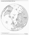
The GIUK gap in the North Atlantic (showing international boundaries as of 1983)

