
Port Jackson facts for kids
Quick facts for kids Port Jackson |
|
|---|---|
_V2.jpg)
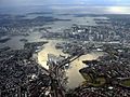
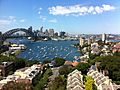
Port Jackson seen from the air in 2006
|
|

Port Jackson
Location in Sydney
|
|
| Location | Sydney, New South Wales, Australia |
| Coordinates | 33°51′30″S 151°14′00″E / 33.85833°S 151.23333°E |
| River sources | Parramatta, Lane Cove, Middle Harbour |
| Ocean/sea sources | Tasman Sea of the South Pacific Ocean |
| Basin countries | Australia |
| Islands | Clark, Shark, Goat, Fort Denison |
| Settlements | Sydney |
Port Jackson is a famous natural harbour in Sydney, New South Wales, Australia. It includes the waters of Sydney Harbour, Middle Harbour, North Harbour, and the Lane Cove and Parramatta Rivers.
This harbour is an inlet of the Tasman Sea, which is part of the South Pacific Ocean. It is home to the iconic Sydney Opera House and Sydney Harbour Bridge. Port Jackson was the site of the first European settlement in Australia. It has always been very important to Sydney's growth and history.
Many fun events happen on or around the harbour. These include the huge Sydney New Year's Eve celebrations. The harbour is also where the famous Sydney to Hobart Yacht Race begins.
Sydney Harbour National Park protects many islands and areas along the shore. These places offer swimming, bushwalking, and picnic spots. The harbour is also a special place for many different kinds of sea creatures and plants.
Contents
History of Port Jackson


Before Europeans arrived, the land around Port Jackson was home to the Eora people. Different groups, like the Gadigal, Cammeraygal, and Wangal, lived here. The Gadigal lived on the south side of the harbour. The Cammeraygal lived on the north side. The Wangal lived along the southern banks of the Parramatta River.
How Port Jackson Got Its Name
The first European to see Sydney Harbour was Lieutenant James Cook in 1770. He named the inlet after Sir George Jackson, who worked for the British Navy. As Cook's ship, the Endeavour, sailed past the entrance, he wrote in his journal about a "bay or harbour" that seemed like a safe place for ships. He called it Port Jackson.
The First Fleet Arrives
Eighteen years later, in 1788, the First Fleet arrived. This was a group of ships carrying the first European settlers to Australia. Governor Arthur Phillip explored Port Jackson after arriving at Botany Bay. He found a perfect spot at Sydney Cove.
On January 26, 1788, Phillip returned to Sydney Cove. He set up the first colony in Australia there. This colony later grew into the city of Sydney. Phillip described Port Jackson as a "capacious harbour, equal, if not superior to any yet known in the world." He noted it had safe places for ships and a good spot to land.
Important Events at the Harbour
In August 1908, the "Great White Fleet" of the United States Navy visited Port Jackson. From 1938, seaplanes used Rose Bay in Sydney Harbour as Sydney's first international airport.
Attack on Sydney Harbour

During World War II in 1942, Sydney Harbour was attacked by Japanese midget submarines. To protect the harbour, a large anti-submarine net was built. It stretched across the harbour from Watsons Bay to Georges Head.
After the war, the net was taken down. Today, you can still see the foundations of the old winch house at Watsons Bay. Parts of the Japanese midget submarines are now on display at the Australian War Memorial and the Royal Australian Navy Heritage Centre.
Harbour Fortifications
Over the years, many forts and defences were built around Sydney Harbour. These were made to protect Sydney from attacks by sea or from convict uprisings. Fort Denison is a famous island fort in the harbour.
Other historical forts include the Middle Head Fortifications and the Georges Head Battery. These forts were built from sandstone and had tunnels, underground rooms, and places for cannons.
Geography of Port Jackson


Port Jackson is a "drowned river valley," which means it was formed when sea levels rose and flooded a river valley. It is about 19 kilometers (12 miles) long. The water in the harbour at high tide is enough to fill 562 million cubic meters! The edge of the harbour is 317 kilometers (197 miles) long.
Port Jackson includes all the tidal waters inside an imaginary line connecting North Head and South Head. This means it covers North Harbour, Middle Harbour, Sydney Harbour, Darling Harbour, the Parramatta River, and the Lane Cove River.
The harbour has many bays. The bays on the south side are usually wide and round. Those on the north side are often narrow inlets. Many of these bays have beaches. The main part of Sydney, the Sydney central business district, starts at Circular Quay.

Islands in the Harbour
There are several islands in Port Jackson. Some of the well-known ones include Shark Island, Clark Island, Fort Denison, Goat Island, and Cockatoo Island.
Some places that used to be islands, like Garden Island, are now connected to the shore by land. Even so, they often still have "island" in their names.
Rivers and Creeks
Several rivers and creeks flow into Port Jackson:
- Middle Harbour is the northern arm of Port Jackson.
- Parramatta River is the western arm.
- Lane Cove River flows from Thornleigh into the harbour.
- Tank Stream was once a freshwater creek that supplied water to the early colony.
- Johnstons Creek and Duck River are other important waterways.
Climate Around the Harbour

Port Jackson has a warm, humid climate. Summers are warm and a bit humid, while winters are mild. It gets moderate rainfall throughout the year. Because it's close to the Tasman Sea, the harbour area is often cooler and windier than other parts of Sydney. Sea breezes help keep summer temperatures from getting too hot.
Infrastructure Around Port Jackson

Bridges Across the Harbour
Many bridges cross Port Jackson and its waterways:
- The Sydney Harbour Bridge is the most famous, connecting the north and south sides of Sydney.
- Other important bridges include the Gladesville Bridge, Ryde Bridge, and Silverwater Bridge.
- The Anzac Bridge crosses Blackwattle Bay.
- The Spit Bridge and Roseville Bridge cross Middle Harbour.
Tunnels Under the Harbour
There are also tunnels that go under the harbour:
- The Sydney Harbour Tunnel is a road tunnel that opened in 1992. It helps cars get across the harbour.
- New rail tunnels have also been built as part of the Sydney Metro project.
- Another road tunnel, the Western Harbour Tunnel, is planned to open in 2026.
Cruise Ship Terminals
Large cruise ships dock at two main terminals:
- The Overseas Passenger Terminal at Circular Quay.
- The White Bay Cruise Terminal at White Bay.
Working Ports
White Bay and Glebe Island are still working ports. They handle goods like sugar, cement, and gypsum that are important for the city. Most of Sydney's very large shipping has moved to Botany Bay.
Military Bases
Port Jackson is home to several active naval bases for the Royal Australian Navy:
- HMAS Kuttabul
- HMAS Penguin
- HMAS Waterhen
- HMAS Watson
Getting Around on the Water

Sydney Ferries run services from Circular Quay to many places around the harbour. You can take a ferry to Cockatoo Island, Manly, Taronga Zoo, and more.
Water taxis and limousines offer private transport. You can also take sightseeing cruises to see the harbour's beauty. Whale watching tours also start from Port Jackson.
The Mortlake Ferry, also called the Putney Punt, is a special ferry that crosses the Parramatta River.
Maritime Heritage

The Australian National Maritime Museum at Darling Harbour has exhibits about Australia's sea history. You can learn about Indigenous stories, European sailing, and naval defence.
The Sydney Heritage Fleet is a group that restores old ships. Their tall ship, the James Craig, often sails on Port Jackson.
The Royal Australian Navy Heritage Centre at Garden Island has many items and documents about the history of the Royal Australian Navy.
Heritage-Listed Sites
Several places in Port Jackson are important historical sites:
A Special Unit of Measure
Did you know that "a Sydharb" is a unit of volume used in Australia? It means the amount of water in Sydney Harbour (Port Jackson). One Sydharb is about 500 billion liters of water!
Images for kids
-
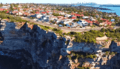
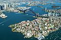
Sydney Harbour seen from above, looking over the suburb of Vaucluse.
-
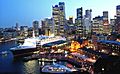
The Queen Elizabeth 2 cruise ship docked at Sydney Harbour.
-
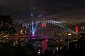
Sydney Harbour on New Year's Eve.
-
A view of Port Jackson and Sydney's CBD.
-
Sydney Harbour from Circular Quay.
-
Aerial view of Sydney Harbour, the Sydney Harbour Bridge, and the Sydney Opera House.
-
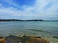
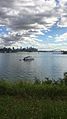
Port Jackson, seen from Rose Bay.
-
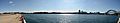
A panoramic view of Sydney Harbour from Millers Point.
-
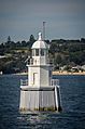
The East Channel Marker in Sydney Harbour, also called the East Wedding Cake.
-
View of the harbour and the Sydney Harbour Bridge from Vaucluse.
-
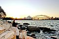
A sunset view of the harbour from Mrs. Macquarie's Chair.
-
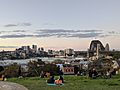
View over the Harbour from Observatory Park.


_03.jpg)


See also
 In Spanish: Bahía de Sídney para niños
