
Harrow, London facts for kids
Quick facts for kids Harrow |
|
|---|---|
    Clockwise from top: St John the Baptist, Greenhill church; Skipping Katie statue; University of Westminster; Hygeia Building and King's House
|
|

Harrow
|
|
| Population | 149,246 (2011 Census) |
| Demonym | Harrovian |
| OS grid reference | TQ145885 |
| • Charing Cross | 11 mi (18 km) ESE |
| London borough | |
| Ceremonial county | Greater London |
| Region | |
| Country | England |
| Sovereign state | United Kingdom |
| Post town | HARROW |
| Postcode district | HA1, HA2, HA3 |
| Dialling code | 020 |
| Police | Metropolitan |
| Fire | London |
| Ambulance | London |
| EU Parliament | London |
| UK Parliament |
|
| London Assembly |
|
Harrow is a large town in Greater London, England. It's the main town in the London Borough of Harrow. Harrow is about 9.5 miles (15 km) north-west of Charing Cross in central London.
In 2011, the town of Harrow had a population of 149,246 people. The wider area, called the London Borough of Harrow (which includes places like Pinner and Stanmore), had about 250,149 people.
The original settlement was on top of Harrow on the Hill, a 408-foot (124 m) tall hill. The modern town centre of Harrow grew at the bottom of this hill. This happened after the Harrow-on-the-Hill station opened in 1880. Harrow became a popular suburban area in the early 1900s.
Another station, Harrow & Wealdstone station, opened in 1837. It was further from the hill. Many people came to Harrow for work because of factories like the large Kodak factory. This factory made photographic materials for over 100 years.
Harrow was historically part of Middlesex county. It became part of Greater London in 1965. Today, Harrow on the Hill is a historic area with old buildings and is home to Harrow School. This is one of England's famous boarding schools for boys. The modern town is a busy shopping and business centre. It also has a campus of the University of Westminster.
Contents
What's in a Name?
Harrow's name comes from an Old English word, hearg. This word likely meant '(heathen) temple'. This temple was probably on Harrow Hill, where St. Mary's Church stands today.
The area now known as Greenhill was once a small farming village. Its name might come from a local green hill or from a family name. It was first mentioned in 1334 as Grenehulle. Today, the name Greenhill is still used for a road, Greenhill Way, which goes around the main shopping area. It's also the name of a local election area.
Harrow's Story

The modern centre of Harrow was once a small farming village called Greenhill. For nearly 1,000 years, the main part of Harrow was on top of the hill. But this started to change in the 1800s. Around 1852, Greenhill had only a few houses and an inn.
In 1850, a local board was set up to manage the central part of Harrow, including Greenhill.
How Harrow Grew

By 1865, some roads were built in Greenhill, but not many houses. A church, St John's Church, was built in 1866. Greenhill became its own church area in 1896. The church building is now a Grade II listed building.
When Harrow-on-the-Hill station opened in 1880, many new houses were built. The population grew quickly. New developments in nearby areas like Headstone and Wealdstone soon joined up with Greenhill. The original village disappeared into the growing town.

In 1899, a car accident happened at Grove Hill and Lowlands Road. This is believed to be one of Britain's earliest car accidents involving a death. A plaque marks this spot.
In 1894, Harrow became an urban district. The new town centre around the station became known simply as Harrow. This helped tell it apart from the old village on the hill. In 1934, the district became larger and was just called Harrow. In 1965, Harrow became a London borough. One of the oldest buildings still standing in Harrow is Headstone Manor, which dates back to the 1400s.
Harrow played a big part in the UK's photography industry. The American Eastman Kodak company built a large factory in Wealdstone in 1890. By 1965, this site had over 100 buildings and employed 5,500 people. The factory operated for 125 years. Its tall chimney is a well-known landmark in Harrow.

In 1914, a large shop called Sopers opened on Station Road. This later became a Debenhams store, which closed in 2021.
Between World War I and World War II, Harrow grew into a suburb. Most of the houses in Harrow today were built during this time.
Train Incidents
The growth of Harrow is closely linked to the railways. The building of the Metropolitan Railway helped Harrow expand.
Harrow has been the site of several serious train incidents.
- In 1838, Thomas Port was badly hurt in a train accident near Harrow and later died.
- In 1870, two trains crashed at Harrow & Wealdstone station, causing 9 deaths and 44 injuries.
- In 1952, three trains collided at Harrow & Wealdstone station. This was a very serious accident, resulting in 112 deaths. It is the greatest loss of life in any UK railway accident during peacetime.
World War II and Beyond
Some sources say that one of the earliest bombing raids by the German air force (Luftwaffe) during World War II happened in Harrow and Wealdstone on August 22, 1940. It damaged buildings but caused no deaths.

By the 1950s, Harrow was a very important suburban area. The Harrow Civic Centre building was built between 1970 and 1972. It opened in 1973. In the 1960s and 1970s, many new office buildings were constructed in the town.
In 1974, a large artwork called the Kodak Mural was finished inside the Civic Centre. It uses almost 1,000 photographic tiles to show Harrow and its connection to Kodak.


The town centre was improved in the 1980s. A bus station was built, and St Anns Road became a pedestrian-only area. A statue called "Skipping Katie" was put up in 1987 to celebrate this. In 2004, Queen Elizabeth II unveiled a plaque on the statue to mark 50 years of the London Borough of Harrow.
In 1987, Diana, Princess of Wales visited Harrow to open the new St Anns shopping centre. This centre was built where a school used to be.
Another shopping centre, St George's, opened in 1996. Other new buildings from this time include the Hygeia building (1991), which has a golden statue of the Roman goddess Hygeia. Also in 1991, the Lower Mead football stadium was sold and replaced by a large Tesco supermarket.
Harrow Today

Harrow town centre has seen many new developments recently. In 2011, Station Road was made wider for two-way bus traffic. New luxury apartments like Bradstowe House were completed in 2016. Old office buildings have been turned into new homes and shops.
A new eight-storey building called Trident Point was built, which includes a Morrisons supermarket. The old post office building near the train station is being turned into a 19-storey skyscraper called Harrow Square. This development includes 318 apartments and a new library.
The council plans to invest a lot of money to improve the town centres of Harrow and Wealdstone.
Harrow's Landscape

The area of Harrow is quite green and suburban. This is partly because of the "Metroland" developments in the early 1900s.
The town centre is about 220 feet (67 m) above sea level. This is almost 200 feet (61 m) below the top of Harrow on the Hill, which is a separate small hill. The hill is half a mile south of the town centre. It has historic buildings and feels like a village.

There is also farmland close to the town, on the eastern side of Harrow on the Hill. This open land is only half a mile from Harrow's town centre. It is next to Northwick Park Hospital and the Northwick Park open space.
Harrow has many parks and open spaces, including:
- The Grove open space
- Harrow Recreation Ground
- West Harrow Recreation Ground
- Kenton Recreation Ground
- Alexandra Park in South Harrow
- Newton Park in Rayners Lane
- Byron Recreation Ground in Wealdstone
- The grounds of Headstone Manor
Harrow is the main town in the London Borough of Harrow. The borough also includes the towns of Pinner and Stanmore.
The Harrow postcode area (HA) covers the entire borough and parts of nearby areas like Ruislip and Edgware. The postcodes for Harrow town itself are HA1, HA2, and HA3.
Harrow is about 1.9 miles (3.1 km) from Pinner, and about 2.7 miles (4.3 km) from Wembley, Stanmore, and Northolt.
 |
North Harrow, Headstone, Pinner | Wealdstone, Harrow Weald | Kenton, Belmont, Canons Park | |
| West Harrow, Rayners Lane, Eastcote | Kenton, Kingsbury | |||
| South Harrow, Northolt, South Ruislip | Harrow on the Hill, Sudbury, North Greenford | North Wembley, Preston |
Harrow's Economy

Central Harrow is a busy business area in north-west London. It has many shops, offices, and new apartments. Harrow is considered one of London's 13 main metropolitan centres.
The town has two shopping centres, St Anns and St George's. These centres have many well-known chain stores. There are also many shops along Station Road and College Road. A large Debenhams store used to be on Station Road. After it closed, the site is becoming a new independent department store called The Landmark. Harrow also has large Morrisons and Tesco supermarkets.
.jpg)
The opening of St George's shopping centre in 1996 made Harrow a stronger shopping destination. In 2015, Harrow was ranked 99th out of 100 top UK retail locations. It was 5th in Greater London. In 2018, Harrow was ranked 59th in a nationwide "High Street Investment Ranking."
The Wealdstone area of Harrow has a strong history of industry. Companies like Winsor & Newton (art supplies) and Kodak were located there.
Who Lives in Harrow?

The town of Harrow includes areas like Harrow on the Hill, Harrow Weald, Headstone, North Harrow, Kenton, Rayners Lane, South Harrow, Wealdstone, and West Harrow. The entire borough of Harrow had a population of 250,149 in 2011.
Harrow has a higher-than-average number of Jewish, Muslim, and Hindu residents. There is a large Gujarati Indian community. Many of them settled in Harrow after being expelled from Uganda in 1972.
In a 2018 survey, the borough of Harrow was found to be the "happiest" in London. However, another survey in 2019 suggested it was the "least friendly" in London.
The average house price in Harrow was £479,682 in 2017.
| Ward | Detached | Semi-detached | Terraced | Flats and apartments |
|---|---|---|---|---|
| Greenhill | 4.7% | 18.6% | 11.5% | 65.1% |
| Harrow on the Hill | 18.7% | 19.5% | 51.5% | |
| Harrow Weald | 17.3% | 46.7% | 14.8% | 21.1% |
| Headstone North | 12.7% | 63.2% | 7.2% | 16.8% |
| Headstone South | 5.4% | 36.6% | 20.4% | 37.5% |
| Kenton East | 4.3% | 35.2% | 42.8% | 17.6% |
| Kenton West | 2.8% | 66.6% | 19.7% | 11.0% |
| Marlborough | 4.8% | 30.6% | 20.5% | 44.1% |
| Rayners Lane | 7.0% | 37.9% | 38.6% | 16.4% |
| Roxbourne | 3.6% | 20.7% | 37.6% | 38.0% |
| Roxeth | 4.4% | 49.4% | 25.2% | 20.9% |
| Wealdstone | 4.5% | 28.8% | 34.7% | 32.1% |
| West Harrow | 5.6% | 48.1% | 19.9% | 26.4% |
How Harrow is Governed
The local government for Harrow is the Harrow Council. It has been led by the Labour Party since 2014. The town of Harrow is divided into 13 areas called wards. Each ward is represented by three local councillors.
Harrow is part of the Brent and Harrow area for the London Assembly. This area has been represented by Krupesh Hirani (Labour Party) since May 2021.
Keekira Thammaih was the first person of Indian and Asian descent to be the Mayor of Harrow. This was in 2000–2001.
Most of Harrow town is part of the Harrow West parliamentary area. This area is currently represented by Gareth Thomas (Labour Party). Eastern parts of Harrow, like Kenton, are in the Harrow East area. This area is represented by Bob Blackman (Conservative Party).
Learning in Harrow
.jpg)
Harrow is famous for Harrow School. This is an independent boarding school for boys, founded in 1572. It is known as one of the best secondary schools in the world. The nearby John Lyon School is another independent school for boys. The North London Collegiate School for girls is located further away in Edgware.
Harrow is also home to a large campus of the University of Westminster. This campus is near Northwick Park Hospital. It is the university's centre for Media, Arts, and Design. The school started in 1897, focusing on art, photography, and fashion. It became a college in the 1960s and joined the University of Westminster in 1990.
Other schools and colleges in or near central Harrow include:
- Harrow High School
- Whitmore High School
- St Dominic's Sixth Form College
- Salvatorian College
- Harrow College
Arts and Entertainment

The borough's Harrow Arts Centre is in Pinner. It has a theatre and rooms for different arts groups.
The St George's centre has a large Vue cinema. There was once another cinema, the Granada Theatre, which opened in 1937. It closed in 1996 and is now a health club.

An art-deco cinema called Dominion opened in 1936. It later became the Safari cinema, showing Bollywood films. This cinema closed, and plans to restore its art-deco design and build apartments were approved in 2020.
Places of Worship

Important churches in Harrow include:
- St Mary's Church (Grade I listed)
- St John's Greenhill
- All Saints Harrow Weald
- Holy Trinity Wealdstone
- Christ Church Roxeth
- Kenton Methodist Church
Harrow also has a Hindu temple called Sri Ayyappan Kovil in Wealdstone. The large Harrow Central Mosque is in the same area. There is also the Mosaic Reform Synagogue on Bessborough Road and a United Synagogue in Kenton. A Zoroastrianism centre is in Rayners Lane.
Harrow in Media
The 1918 book The Return of the Soldier is set in Harrow.
Some TV shows and movies have been filmed in Harrow:
- The wedding of Peggy Mitchell and Frank Butcher in EastEnders (1999) was filmed here.
- A classroom scene in Harry Potter and the Philosopher's Stone was filmed at Harrow School.
- Many scenes of the drama The Crown were also filmed at Harrow School.
- The British Asian soap drama Cloud 9 was shot in Harrow in 2013.
- The outside of Clark's house in the 2016 film Me Before You was filmed in Harrow.
The Harrow Times is a local newspaper for the area. Radio Harrow is a local charity radio station that broadcasts from Northwick Park Hospital.
Sports and Recreation
Harrow has two main football clubs:
- Wealdstone F.C. plays in the National League (fifth tier). They are based in Ruislip.
- Harrow Borough F.C. plays at Earlsmead Stadium in the Isthmian League Premier Division (seventh tier).
Harrow Leisure Centre and Harrow Skate Park are located near Byron Park in Wealdstone. There is also a golf course at Northwick Park.
Public Services

The Metropolitan Police patrols the borough of Harrow. Police services are mainly provided from Harrow Police Station in South Harrow.
Harrow is served by Northwick Park Hospital. There are also specialist hospitals like St Mark's Hospital and Royal National Orthopaedic Hospital (in Stanmore). A private hospital called Clementine Churchill is located in Harrow-on-the-Hill.
Getting Around Harrow
Trains and Underground

Harrow has many London Underground and National Rail services:
- Harrow-on-the-Hill (Metropolitan line & Chiltern Railways)
- Harrow & Wealdstone (Bakerloo line, London Overground, London Northwestern Railway and Southern)
- West Harrow (Metropolitan line)
- South Harrow (Piccadilly line)
- Rayners Lane (Metropolitan/Piccadilly lines)
- North Harrow (Metropolitan line)
- Kenton (Bakerloo line & London Overground)
- Headstone Lane (London Overground)
- Northolt Park (Chiltern Railways)
- Sudbury Hill Harrow (Chiltern Railways)
- Northwick Park (Metropolitan line)
- Sudbury Hill (Piccadilly line)
Harrow-on-the-Hill is the main station in the town centre. It offers direct train and Underground links to central London, Uxbridge, and beyond. Harrow & Wealdstone station is a bit further north. It is a very busy station with direct trains to central London, Croydon, Gatwick Airport, and other towns. Both stations are in Travelcard zone 5.
In 1991, a bomb was placed on a train at Harrow-on-the-Hill station. Thankfully, no one was hurt.
Buses
.jpg)
Harrow bus station is next to the St Anns shopping centre. All buses are managed by Transport for London. Buses connect Harrow to many nearby areas like Ruislip, Watford, Edgware, and Heathrow Airport.
Harrow was one of the first places to test electronic contactless smart card technology on buses. This trial started in 1994 and was very successful. It led to the development of the Oyster card, which is now used across London.
Roads
Harrow does not have major trunk roads directly passing through it. The A312 road starts in Harrow, but it becomes a primary road further away in Northolt. From there, you can connect to the A40 Western Avenue. The M1 motorway is about 6 miles (9.7 km) away via the A41 in Edgware.
Images for kids
-
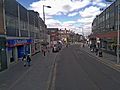
Station Road, Harrow
-
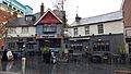
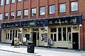
Royal Oak public house on St Anns Road has existed since the early 20th century and is locally listed
-
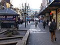
St Anns Road
-
St Anns Road
-
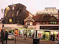
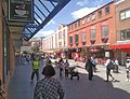
Middle section of Station Road, showing shops and the Time Building and apartments on Lyon Road behind it
-
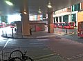
Harrow's central bus station
-
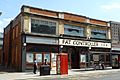
Former Fat Controller pub, closed in 2010
-
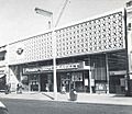
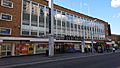
Premier Supermarket on Station Road (1963), now an Iceland supermarket; the site was originally home to the Harrow Coliseum cinema which was demolished in 1956
-
Moon on the Hill pub
-
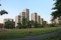
New built Harrow Square blocks
-
The old Debenhams shortly before its closure in May 2021. The site is becoming an independent department store called The Landmark.
-
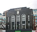
The Time Building on Station Road with a Miller-branded clock - formerly home of Time nightclub in 2000; today part converted into residential use


.jpg)

.jpg)

Famous Faces from Harrow
-

Sir Elton John

.jpg)


.jpg)
