Hollister, California facts for kids
Quick facts for kids
Hollister
|
||
|---|---|---|
|
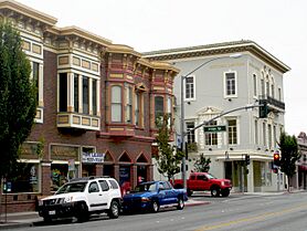
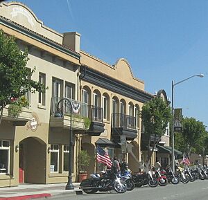
Downtown Hollister
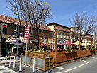
Street-side dining area
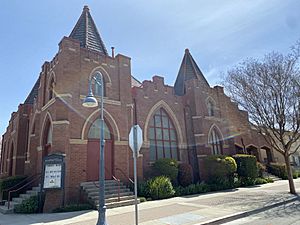
United Methodist Church
vineyards in Hollister
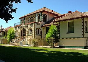
Veteran's Memorial Building
|
||
|
||
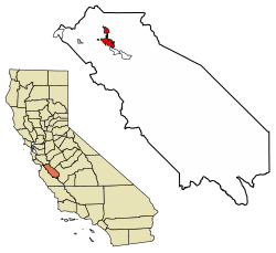
Location of Hollister in San Benito County, California
|
||
| Country | United States | |
| State | California | |
| County | San Benito | |
| Incorporated | August 6, 1872 | |
| Government | ||
| • Type | Council-Manager | |
| Area | ||
| • Total | 7.84 sq mi (20.29 km2) | |
| • Land | 7.84 sq mi (20.29 km2) | |
| • Water | 0.00 sq mi (0.00 km2) 0% | |
| Elevation | 289 ft (88 m) | |
| Population
(2020)
|
||
| • Total | 41,678 | |
| • Estimate
(2019)
|
40,740 | |
| • Density | 5,199.08/sq mi (2,007.43/km2) | |
| Time zone | UTC−08:00 (Pacific (PST)) | |
| • Summer (DST) | UTC−07:00 (PDT) | |
| ZIP code |
95023
|
|
| Area code(s) | 831 | |
| FIPS code | 06-34120 | |
| GNIS feature IDs | 1658766, 2410778 | |
Hollister is a city in California, United States. It is the main city of San Benito County. Hollister is located in the Central Coast area of California.
In 2020, about 41,678 people lived in Hollister. This makes it one of the largest cities in the Monterey Bay Area. Hollister is known for its farms, especially for growing Blenheim apricots, olive oil, vineyards, pomegranates, and making chocolate.
Contents
History of Hollister
Long ago, the Mutsun people, a group of Ohlone Indians, lived in the area where Hollister is now. In 1797, the Mission San Juan Bautista was built, and the Ohlone people became part of the California mission system.
The town of Hollister was started on November 19, 1868. It was founded by William Welles Hollister on land that used to be a Mexican ranch called Rancho San Justo. At first, Hollister was part of Monterey County. Later, in 1874, San Benito County was created by the California Legislature. It was made from parts of Monterey, Merced, and Santa Cruz counties.
Motorcycle Rally History
Hollister is famous for its annual motorcycle rally that happens around July Fourth. A well-known event at the first rally in 1947 inspired the 1953 movie The Wild One. The rally was brought back in 1997 as the Hollister Independence Rally.
Over the years, the rally faced some challenges. In 2005, the city stopped working with the event organizers because of money and safety worries. The rally was canceled in 2006 due to a lack of money for security. It returned in 2007 and 2008, but with changes. For example, motorcycles had to park on side streets.
The rally was canceled from 2009 to 2012 but came back in 2013. After an incident in 2014, the city made rules about alcohol sales during the 2015 rally. The 2015 rally also caused the city to lose money. In 2016, a new organizer was hired, and about 40,000 people were expected to attend. The 2017 rally was described as having a "friendly" crowd.
The rally was canceled in 2018 because a main sponsor left and there were concerns about costs. However, unofficial "rebel rallies" still took place in 2018 and 2019. The 2020 rally was canceled due to the 2019–20 coronavirus pandemic. An unofficial rally happened in 2021, but it was smaller. In 2022, the city council decided not to sponsor a rally because there were not enough law enforcement officers.
Geography and Climate
Hollister has a warm-summer Mediterranean climate. This means it has warmer summers than nearby areas like Monterey and Salinas, but it's cooler than many other inland cities in the Central Valley.
Weather in Hollister
Daytime temperatures are usually around 80°F (27°C) between June and October. However, it can get much hotter during heat waves.
| Climate data for Hollister, California (1991–2020 normals, extremes 1895–present) | |||||||||||||
|---|---|---|---|---|---|---|---|---|---|---|---|---|---|
| Month | Jan | Feb | Mar | Apr | May | Jun | Jul | Aug | Sep | Oct | Nov | Dec | Year |
| Record high °F (°C) | 84 (29) |
84 (29) |
91 (33) |
99 (37) |
105 (41) |
108 (42) |
119 (48) |
110 (43) |
111 (44) |
107 (42) |
94 (34) |
81 (27) |
119 (48) |
| Mean maximum °F (°C) | 69.6 (20.9) |
73.8 (23.2) |
79.4 (26.3) |
87.7 (30.9) |
92.3 (33.5) |
97.3 (36.3) |
96.6 (35.9) |
98.6 (37.0) |
99.7 (37.6) |
93.2 (34.0) |
81.1 (27.3) |
69.3 (20.7) |
103.9 (39.9) |
| Mean daily maximum °F (°C) | 59.6 (15.3) |
62.0 (16.7) |
65.6 (18.7) |
69.1 (20.6) |
73.3 (22.9) |
78.0 (25.6) |
79.6 (26.4) |
81.4 (27.4) |
80.9 (27.2) |
76.7 (24.8) |
66.6 (19.2) |
58.9 (14.9) |
71.0 (21.7) |
| Daily mean °F (°C) | 49.1 (9.5) |
51.3 (10.7) |
54.1 (12.3) |
56.8 (13.8) |
60.8 (16.0) |
64.6 (18.1) |
66.7 (19.3) |
67.9 (19.9) |
66.8 (19.3) |
62.3 (16.8) |
54.2 (12.3) |
48.3 (9.1) |
58.6 (14.8) |
| Mean daily minimum °F (°C) | 38.7 (3.7) |
40.7 (4.8) |
42.6 (5.9) |
44.5 (6.9) |
48.4 (9.1) |
51.2 (10.7) |
53.8 (12.1) |
54.4 (12.4) |
52.6 (11.4) |
48.0 (8.9) |
41.9 (5.5) |
37.6 (3.1) |
46.2 (7.9) |
| Mean minimum °F (°C) | 29.0 (−1.7) |
31.4 (−0.3) |
34.1 (1.2) |
36.9 (2.7) |
41.6 (5.3) |
44.9 (7.2) |
48.6 (9.2) |
48.9 (9.4) |
46.2 (7.9) |
40.0 (4.4) |
32.6 (0.3) |
27.6 (−2.4) |
26.2 (−3.2) |
| Record low °F (°C) | 14 (−10) |
19 (−7) |
20 (−7) |
23 (−5) |
31 (−1) |
35 (2) |
37 (3) |
36 (2) |
31 (−1) |
22 (−6) |
20 (−7) |
14 (−10) |
14 (−10) |
| Average precipitation inches (mm) | 3.10 (79) |
2.65 (67) |
2.23 (57) |
0.99 (25) |
0.44 (11) |
0.09 (2.3) |
0.00 (0.00) |
0.01 (0.25) |
0.05 (1.3) |
0.62 (16) |
1.25 (32) |
2.27 (58) |
13.70 (348) |
| Average snowfall inches (cm) | 0.0 (0.0) |
0.0 (0.0) |
0.0 (0.0) |
0.0 (0.0) |
0.0 (0.0) |
0.0 (0.0) |
0.0 (0.0) |
0.0 (0.0) |
0.0 (0.0) |
0.0 (0.0) |
0.0 (0.0) |
0.1 (0.25) |
0.1 (0.25) |
| Average precipitation days (≥ 0.01 in) | 8.3 | 9.6 | 7.1 | 4.8 | 2.1 | 0.6 | 0.2 | 0.2 | 0.4 | 2.7 | 4.6 | 7.4 | 48.0 |
| Average snowy days (≥ 0.1 in) | 0.0 | 0.0 | 0.0 | 0.0 | 0.0 | 0.0 | 0.0 | 0.0 | 0.0 | 0.0 | 0.0 | 0.0 | 0.0 |
| Source: NOAA | |||||||||||||
Earthquakes and Fault Lines
Hollister is famous among geologists because it shows a special type of aseismic creep (slow, steady movement of a fault without large earthquakes). The Calaveras Fault, which is part of the San Andreas Fault system, runs right through the city. You can even see how some streets running across the fault have shifted over time. Some houses are built directly over the fault and are reinforced to handle the slow movement.
Even though there was a lot of damage in Hollister during the 1989 Loma Prieta earthquake, this was caused by the main San Andreas Fault, not the slow creep of the Calaveras Fault. The San Andreas Fault is located a bit away, near San Juan Bautista and the Hollister Hills State Vehicular Recreation Area.
Hollister is one of a few California towns that call themselves the "Earthquake Capital of the World." The city is located on the western hills of the Diablo Range.
Population of Hollister
The population of Hollister has grown a lot over the years. Here's how it has changed:
| Historical population | |||
|---|---|---|---|
| Census | Pop. | %± | |
| 1880 | 1,034 | — | |
| 1890 | 1,234 | 19.3% | |
| 1900 | 1,315 | 6.6% | |
| 1910 | 2,308 | 75.5% | |
| 1920 | 2,781 | 20.5% | |
| 1930 | 3,757 | 35.1% | |
| 1940 | 3,881 | 3.3% | |
| 1950 | 4,903 | 26.3% | |
| 1960 | 6,071 | 23.8% | |
| 1970 | 7,663 | 26.2% | |
| 1980 | 11,488 | 49.9% | |
| 1990 | 19,212 | 67.2% | |
| 2000 | 34,413 | 79.1% | |
| 2010 | 34,928 | 1.5% | |
| 2020 | 41,678 | 19.3% | |
| U.S. Decennial Census | |||
Population in 2020
In 2020, Hollister had 41,678 people.
- About 36.1% of the people were white.
- About 4.1% were Asian American.
- About 1.0% were black or African American.
- About 0.3% were Pacific Islander.
- About 2.8% were Native American.
- About 18.2% were from two or more races.
- A large group, about 68.9%, were Hispanic or Latino (of any race).
Population in 2010
In 2010, Hollister had 34,928 people.
- About 29.1% of the people were White.
- About 1.0% were African American.
- About 1.8% were Native American.
- About 2.7% were Asian.
- About 0.2% were Pacific Islander.
- About 29.9% were from other races.
- About 5.1% were from two or more races.
- About 65.7% of the people were Hispanic or Latino (of any race).
Most people (99.7%) lived in homes. There were 9,860 households. About 53.7% of these homes had children under 18 living there. The average household had about 3.53 people.
The population was quite young:
- About 31.7% were under 18 years old.
- About 10.1% were aged 18 to 24.
- About 28.4% were aged 25 to 44.
- About 22.3% were aged 45 to 64.
- About 7.4% were 65 years or older.
The average age in Hollister was 30.8 years.
Local Media
Newspapers
- The Hollister Free Lance is a newspaper published every Friday.
- The Mission Village Voice is a monthly newspaper that also has an online version. It focuses on events, arts, and culture in San Juan Bautista and San Benito County.
Television and Radio
- CMAP TV (Community Media Access Partnership) runs Channels 17, 18, 19, and 20 on Charter/Spectrum Cable. They also stream online. They offer public and educational shows for Gilroy and San Benito County, including live coverage of Hollister city government meetings.
- Several radio stations are licensed to Hollister, playing different types of music and programming.
City Infrastructure
Transportation Options
Highways for Travel
 SR 25 goes northwest towards the San Francisco Bay Area and southeast to Pinnacles National Park.
 SR 156 goes west to Monterey Bay and northeast to Los Banos.
 US 101 is about 15 miles (24 km) to the west. This is a major highway that connects Hollister to the rest of the Central Coast, San Francisco (north), and Los Angeles (south).
 Interstate 5 is about 40 miles (64 km) to the east. This is another big highway that links Hollister north to Sacramento and south to Los Angeles.
Public Transport
- San Benito County Express offers local bus service within Hollister. It also has regional service to San Juan Bautista and Gilroy. In Gilroy, you can connect to the Caltrain system. They also have a "Dial-a-Ride" service you can request.
Airports
- For international flights, people use San Jose International Airport, which is about 50 miles (80 km) away in San Jose.
- The Monterey Regional Airport, about 40 miles (64 km) away, connects Hollister to larger cities in California and other states.
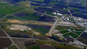
- Hollister Municipal Airport is a smaller airport used for general aviation (private planes and small aircraft).
Healthcare Services
Hollister has Hazel Hawkins Memorial Hospital. This hospital provides general acute care and basic emergency services. As of 2014, the hospital has 113 beds.
Notable People from Hollister
- Conner Menez: A Pitcher who was born in Hollister.
- Brendon Clark: A retired Australian bull rider who lives in Hollister.
- Charlie Root: A famous pitcher.
- Stanley F. Schmidt: An aerospace engineer.
- Mikiso Hane: A history professor at Knox College.
See also
 In Spanish: Hollister (California) para niños


