Hotwells facts for kids
Quick facts for kids Hotwells |
|
|---|---|
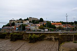
 The western part of Hotwells, with the bank of the River Avon and the A4 Hotwell Road in the foreground and the higher houses of Clifton Village above. The Clifton Suspension Bridge is just visible on the left. |
|
| Area | 0.155 sq mi (0.40 km2) |
| Population | 3,002 |
| • Density | 19,368/sq mi (7,478/km2) |
| OS grid reference | ST572727 |
| Unitary authority | |
| Ceremonial county | |
| Region | |
| Country | England |
| Sovereign state | United Kingdom |
| Post town | BRISTOL |
| Postcode district | BS8 |
| Dialling code | 0117 |
| Police | Avon and Somerset |
| Fire | Avon |
| Ambulance | Great Western |
| EU Parliament | South West England |
| UK Parliament |
|
Hotwells is a cool neighbourhood in the port city of Bristol, England. It's located just south of the higher area called Clifton. It sits right next to the Floating Harbour. The entrance to the Avon Gorge, which links the docks to the sea, is at the west end of Hotwells.
Contents
Hotwells Location and Surroundings
Hotwells is about 1.6 kilometers (1 mile) west of Bristol city centre. It lies just north of the Floating Harbour and the River Avon. To the north, and about 90 meters (300 feet) higher, is the suburb of Clifton.
Much of this area was once a salt marsh called Rownham Mead. In the early 1800s, almost half of Rownham Mead was dug out. This was done to build the Cumberland Basin. This basin is a key part of the lock system for ships entering the city docks.
The western part of Hotwells is where the Portway road begins. This road connects Bristol to Avonmouth. It passes right under the famous Clifton Suspension Bridge. This bridge is about 0.4 kilometers (0.25 miles) north of Hotwells.
Hotwells History and Development
Hotwells gets its name from the hot springs found here. These springs bubble up through the rocks in the Avon Gorge. They are located right under the Clifton Suspension Bridge.
Early Discoveries and Spa Era
The hot springs were first written about in 1480. William Worcester, a writer from the 15th century, described them. He said the water was milky and as warm as the springs in Bath.
In 1692, a group called the Society of Merchant Venturers leased the springs. They built a pump room for people to use the waters. This first pump room was later replaced by Hotwells House in 1816. However, Hotwells House was also taken down in 1867 when the river was made wider.
During the Georgian era (1714–1837), Hotwells became a popular spa town. Buildings like Dowry Square were built to try and compete with Bath. Many famous visitors came here. This included the diarist John Evelyn and travel writer Celia Fiennes. They even looked for "Bristol Diamonds" (quartz crystals) in the gorge.
The Jacobs Well Theatre, built in 1729, offered entertainment. It was for both visitors and people from Bristol. Despite all this, Hotwells never became as famous as Bath. Eventually, people found out the spring waters were polluted. A new pump room was built in 1822, but it was also demolished in 1867. This was to make way for widening the River Avon.
Scientific Discoveries in Hotwells
In 1799, a doctor named Thomas Beddoes opened the Pneumatic Institution. This was in Dowry Square. They offered free treatment for illnesses like asthma.
The laboratory manager was Humphry Davy. He studied nitrous oxide, also known as laughing gas. He used special equipment designed by James Watt. Under Davy's guidance, they even held laughing gas parties! Guests included famous writers like Robert Southey and Samuel Taylor Coleridge.
Modern Hotwells
In the 1900s, many homes in Hotwells were in poor condition. But since the 1970s, things have changed. Older Georgian buildings have been fixed up. New homes have also been built on old dockside areas and along Hotwell Road.
Hotwells Architecture and Notable Buildings
Hotwells has several important buildings. Grenville Chapel, a Methodist church, opened in 1839. It was built in an Early English style. For many years, it was used as a garage. Now, it has been turned into flats managed by a housing association.
Hotwells is home to some of Bristol's Grade II* listed buildings. These are buildings with special historical or architectural importance. They include the Church of Holy Trinity, designed by Cockrell. Albemarle Row, a beautiful Georgian terrace, is also listed.
Another listed building is the Pump House. This building used to be the power plant for Bristol Harbour's bridges. It also powered other machinery. Today, it is a popular public house (a pub).
Education in Hotwells
The area has two primary schools for younger students. These are Hotwells Primary School and St George C of E Primary School. The nearest secondary schools for older students are Ashton Park School, Cotham School, and Bristol Cathedral Choir School.
Transport in Hotwells

Towards the end of the 1800s, the west end of Hotwells was a busy transport hub. It was the end point for a Bristol Tramways route. Hotwells railway station was the city's train station for the Bristol Port Railway and Pier line to Avonmouth. It was also the lower station for the Clifton Rocks Railway.
The Rownham Ferry crossed the River Avon to Bower Ashton from here. There were also locks for ships to enter the Floating Harbour. Passenger steamers used the landing stages in this area.
In the 1920s, the A4 Portway Road was built through the Avon Gorge. This road made it easier to get from the city to Avonmouth Docks. Building this road removed all traces of the old Bristol Port Railway and Pier station. Since the 1960s, the western end of Hotwells has been dominated by a large flyover. This allows traffic from the city centre and the A4 Portway to cross the river and harbour entrance. It helps cars reach the south west of the city.
Today, public transport includes buses that pass through Hotwells. These buses go to towns like Weston-super-Mare, Clevedon, and Portishead. There is also a ferry service that goes to the city centre and Temple Meads railway station.
Hotwells Community Life
The Hotwells and Cliftonwood Community Association (HCCA) is a charity. It's run by volunteers who want to make life better for people living and working here. For many years, the HCCA ran the Hope Centre. This centre was in the historic Georgian Hope Chapel. It was a place for community groups and hosted art events. The Hope Centre closed in 2001 due to a lack of funding.
Since 1981, the Hotwells Pantomime group has performed every year in Hope Chapel. The actors and crew are all local volunteers. They give their time to raise money for local charities and have a lot of fun doing it!
 | Janet Taylor Pickett |
 | Synthia Saint James |
 | Howardena Pindell |
 | Faith Ringgold |


