Cocos (Keeling) Islands facts for kids
Quick facts for kids
Cocos (Keeling) Islands
|
||
|---|---|---|
| Territory of Cocos (Keeling) Islands Pulu Kokos (Keeling) (Cocos Islands Malay) Wilayah Kepulauan Cocos (Keeling) (Malay) |
||
|
||
| Motto(s):
"Maju Pulu Kita" (Cocos Islands Malay)
(English: "Onward our island") |
||
| Anthem: "Advance Australia Fair" | ||
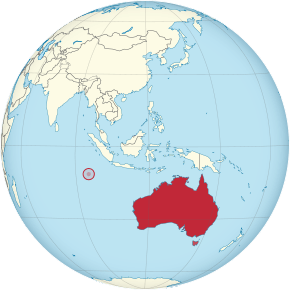
Location of the Cocos (Keeling) Islands (circled in red)
|
||
| Sovereign state | ||
| Annexed by the United Kingdom | 1857 | |
| Transferred from Singapore to Australia |
23 November 1955 | |
| Capital | West Island 12°11′13″S 96°49′42″E / 12.18694°S 96.82833°E |
|
| Largest village | Bantam (Home Island) | |
| Official languages | None | |
| Spoken languages |
|
|
| Government | Directly administered dependency | |
|
• Monarch
|
Elizabeth II | |
| David Hurley | ||
|
• Administrator
|
Natasha Griggs | |
|
• Shire President
|
Aindil Minkom | |
| Area | ||
|
• Total
|
14 km2 (5.4 sq mi) | |
|
• Water (%)
|
0 | |
| Highest elevation | 5 m (16 ft) | |
| Population | ||
|
• 2016 census
|
544 (not ranked) | |
|
• Density
|
43/km2 (111.4/sq mi) (not ranked) | |
| GDP (nominal) | 2010 estimate | |
|
• Total
|
US$11,012,550 | |
| Currency | Australian dollar (AUD) | |
| Time zone | UTC+06:30 | |
| Driving side | left | |
| Calling code | +61 891 | |
| Postcode |
WA 6799
|
|
| ISO 3166 code | CC | |
| Internet TLD | .cc | |
The Cocos (Keeling) Islands (also called Pulu Kokos (Keeling) in the local language) are a special territory of Australia. They are a small group of islands in the Indian Ocean, located about halfway between Australia and Sri Lanka. They are also quite close to the Indonesian island of Sumatra.
These islands are officially known as the Territory of Cocos (Keeling) Islands. Their double name became official in 1955 when they became part of Australia. This is because people used to call them either the Cocos Islands or the Keeling Islands.
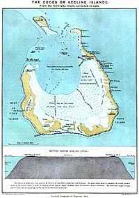
The territory is made up of two atolls, which are ring-shaped coral reefs with a lagoon in the middle. There are 27 coral islands in total, but only two of them are lived on: West Island and Home Island. About 600 people live here, mostly Cocos Malays. Most of them follow the Sunni Islam religion and speak a type of Malay language as their first language.
The Australian government manages the islands. They are grouped with Christmas Island (which is about 960 km (600 mi) to the east) as the Australian Indian Ocean Territories. However, the islanders also have some say in how things are run through their local council. Many public services, like health, education, and policing, are provided by the state of Western Australia. The islands even use Western Australian postcodes.
A British sea captain named William Keeling found the islands in 1609. But people didn't start living there until the early 1800s. One of the first settlers was John Clunies-Ross, a Scottish merchant. Many people living on the islands today are related to the Malay workers he brought to work on his coconut plantation. The Clunies-Ross family basically ran the islands like their own private kingdom for almost 150 years. The British took control of the islands in 1857. For the next 100 years, they were managed from places like Ceylon (now Sri Lanka) or Singapore. The islands were officially given to Australia in 1955.
Contents
- Understanding the Cocos (Keeling) Islands' Name
- Exploring the Geography of the Islands
- Climate and Weather on the Islands
- Who Lives on the Cocos Islands?
- A Look at the Islands' History
- How the Cocos Islands Are Governed
- The Islands' Economy
- Plastic Pollution on the Beaches
- Why the Islands are Strategically Important
- Getting Around and Staying Connected
- Media and News
- Learning and Education
- Culture of the Islands
- Special Places and Heritage
- The Pulu Cocos Museum
- Marine Park for Protection
- Images for kids
- See also
Understanding the Cocos (Keeling) Islands' Name
The islands have had a few different names over time. They were called the Cocos Islands starting in 1622. Then, from 1703, they were known as the Keeling Islands. Sometimes they were called the Cocos–Keeling Islands or the Keeling–Cocos Islands.
The name Cocos comes from the many coconut trees found there. Keeling is named after William Keeling, the captain who discovered the islands in 1609.
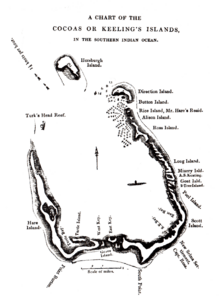
In 1825, John Clunies-Ross sailed to the islands. He called the whole group the Borneo Coral Isles. He used Keeling only for North Keeling and called the southern islands "the Cocos properly so called". The official name, Cocos (Keeling) Islands, has been used since 1916 and was made official by a law in 1955.
The local Malay name for the territory is Pulu Kokos (Keeling). You can see Malay translations on signs around the islands.
Exploring the Geography of the Islands
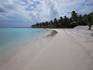
The Cocos (Keeling) Islands are two flat, low-lying coral atolls. They cover an area of about 14.2 square kilometers (5.5 sq mi). The highest point on the islands is only 5 meters (16 ft) above sea level. They are covered with coconut palms and other plants.
The weather is usually nice, with cool breezes for most of the year. There is some rain, but Tropical cyclones can happen in the early months of the year.
North Keeling Island: A Special Nature Park
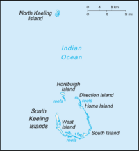
North Keeling Island is one atoll that has only one C-shaped island. It's almost a closed ring with a small opening to the lagoon on the east side. This island is about 1.1 square kilometers (0.42 sq mi) in size and no one lives there. The lagoon inside is about 0.5 square kilometers (0.19 sq mi).
North Keeling Island and the sea around it form the Pulu Keeling National Park. This park was created in 1995. It is home to the only remaining group of the rare Cocos buff-banded rail, a type of bird found only here.
South Keeling Islands: Where People Live
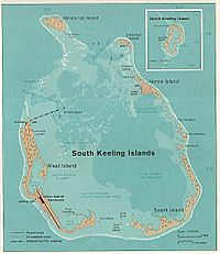
The South Keeling Islands atoll has 24 smaller islands. Their total land area is about 13.1 square kilometers (5.1 sq mi). Only Home Island and West Island have people living on them. The Cocos Malays often have small weekend huts, called pondoks, on many of the larger islands.
There are no rivers or lakes on any of the islands. Fresh water comes from underground pockets of rainwater. These pockets are found above the seawater and are reached through shallow wells.
| Islet (Malay name) |
Translation of Malay name | English name | Area (approx.) |
||
|---|---|---|---|---|---|
| km2 | mi2 | ||||
| 1 | Pulau Luar | Outer Island | Horsburgh Island | 1.04 | 0.40 |
| 2 | Pulau Tikus | Mouse Island | Direction Island | ||
| 3 | Pulau Pasir | Sand Island | Workhouse Island | 0.01 | 0.00 |
| 4 | Pulau Beras | Rice Island | Prison Island | 0.02 | 0.01 |
| 5 | Pulau Gangsa | Copper Island | Closed sandbar, now part of Home Island | 0.01 | 0.00 |
| 6 | Pulau Selma | Home Island | 0.95 | 0.37 | |
| 7 | Pulau Ampang Kechil | Little Ampang Island | Scaevola Islet | 0.01 | 0.00 |
| 8 | Pulau Ampang | Ampang Island | Canui Island | 0.06 | 0.02 |
| 9 | Pulau Wa-idas | Ampang Minor | 0.02 | 0.01 | |
| 10 | Pulau Blekok | Pond Heron Island | Goldwater Island | 0.03 | 0.01 |
| 11 | Pulau Kembang | Flower Island | Thorn Island | 0.04 | 0.02 |
| 12 | Pulau Cheplok | Cape Gooseberry Island | Gooseberry Island | 0.01 | 0.00 |
| 13 | Pulau Pandan | Pandan Island | Misery Island | 0.24 | 0.09 |
| 14 | Pulau Siput | Snail Island | Goat Island | 0.10 | 0.04 |
| 15 | Pulau Jambatan | Bridge Island | Middle Mission Isle | 0.01 | 0.00 |
| 16 | Pulau Labu | Pumpkin Island | South Goat Island | 0.04 | 0.02 |
| 17 | Pulau Atas | Top Island | South Island | 3.63 | 1.40 |
| 18 | Pulau Kelapa Satu | One Coconut Island | North Goat Island | 0.02 | 0.01 |
| 19 | Pulau Blan | East Cay | 0.03 | 0.01 | |
| 20 | Pulau Blan Madar | Burial Island | 0.03 | 0.01 | |
| 21 | Pulau Maria | Maria Island | West Cay | 0.01 | 0.00 |
| 22 | Pulau Kambing | Goat Island | Keelingham Horn Island | 0.01 | 0.00 |
| 23 | Pulau Panjang | Long Island | West Island | 6.23 | 2.41 |
| 24 | Pulau Wak Bangka | Turtle Island | 0.22 | 0.08 | |
Climate and Weather on the Islands
The Cocos (Keeling) Islands have a tropical rainforest climate. This means it's hot and wet all year round. The islands are located about halfway between the equator and the Tropic of Capricorn.
There are two main seasons: a wet season and a dry season. April is usually the wettest month, while October is the driest. Temperatures don't change much because the ocean keeps them steady. March is the hottest month, and August is the coolest.
| Climate data for Cocos Islands Airport | |||||||||||||
|---|---|---|---|---|---|---|---|---|---|---|---|---|---|
| Month | Jan | Feb | Mar | Apr | May | Jun | Jul | Aug | Sep | Oct | Nov | Dec | Year |
| Record high °C (°F) | 32.2 (90.0) |
32.2 (90.0) |
32.7 (90.9) |
32.8 (91.0) |
31.5 (88.7) |
30.8 (87.4) |
30.3 (86.5) |
30.3 (86.5) |
30.1 (86.2) |
31.0 (87.8) |
30.9 (87.6) |
31.4 (88.5) |
32.8 (91.0) |
| Mean daily maximum °C (°F) | 29.8 (85.6) |
29.9 (85.8) |
30.0 (86.0) |
29.8 (85.6) |
29.3 (84.7) |
28.6 (83.5) |
28.1 (82.6) |
28.1 (82.6) |
28.2 (82.8) |
28.6 (83.5) |
29.0 (84.2) |
29.4 (84.9) |
29.1 (84.4) |
| Mean daily minimum °C (°F) | 25.1 (77.2) |
25.2 (77.4) |
25.4 (77.7) |
25.5 (77.9) |
25.4 (77.7) |
24.8 (76.6) |
24.3 (75.7) |
24.3 (75.7) |
24.2 (75.6) |
24.5 (76.1) |
24.8 (76.6) |
24.8 (76.6) |
24.9 (76.8) |
| Record low °C (°F) | 21.0 (69.8) |
20.1 (68.2) |
19.8 (67.6) |
22.2 (72.0) |
21.2 (70.2) |
21.5 (70.7) |
20.5 (68.9) |
20.8 (69.4) |
21.2 (70.2) |
21.3 (70.3) |
20.8 (69.4) |
21.2 (70.2) |
19.8 (67.6) |
| Average rainfall mm (inches) | 153.9 (6.06) |
181.6 (7.15) |
231.4 (9.11) |
262.6 (10.34) |
205.0 (8.07) |
212.3 (8.36) |
220.2 (8.67) |
104.9 (4.13) |
86.4 (3.40) |
88.2 (3.47) |
96.9 (3.81) |
93.5 (3.68) |
1,936.9 (76.25) |
| Average rainy days (≥ 0.2 mm) | 12.9 | 14.2 | 18.3 | 18.3 | 18.9 | 19.2 | 21.4 | 17.2 | 13.5 | 10.1 | 10.1 | 10.6 | 184.7 |
| Source: Bureau of Meteorology | |||||||||||||
Who Lives on the Cocos Islands?
In 2016, there were 544 people living on the islands. About 75% of them are Muslim. Also, about 69.6% of people speak Malay at home instead of English.
The people on the two inhabited islands are generally divided. People of European background live on West Island (about 100 people). The Cocos Malays live on Home Island (about 500 people).
The Kaum Ibu (Women's Group) is an organization that supports women's rights. It shares the views of women at both local and national levels.
Religion in Cocos Islands (2016) Islam (75%) No religion (13.4%) Christianity (5%) Not stated (6.5%) Other (0.1%)
A Look at the Islands' History
How the Islands Were Discovered
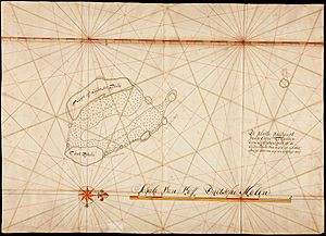
Captain William Keeling of the East India Company discovered the islands in 1609. This happened when he was sailing back from the East Indies. Later, in 1749, a Swedish captain named Ekeberg drew a map of North Keeling. This map showed that coconut palms were already growing there.
In 1825, a Scottish merchant sailor named Captain John Clunies-Ross visited the islands. He put up a Union Jack flag, planning to come back later and settle with his family. Around the same time, a wealthy Englishman named Alexander Hare had a similar idea. He brought 40 Malay women to the islands, hoping to create his own private home.
Clunies-Ross returned two years later with his family. He found Hare already living on the island with his group of women. A disagreement started between the two men. Over time, Hare's women started leaving him to be with Clunies-Ross's sailors. Hare eventually left the island. Clunies-Ross then invited more Malays to come to the island for work and to start families.
Clunies-Ross paid his workers with a special money called the Cocos rupee. This money could only be used at his company store on the island.
On April 1, 1836, the ship HMS Beagle, led by Captain Robert FitzRoy, arrived. They took measurements to understand the shape of the atoll. Charles Darwin, a naturalist on the ship, found that these measurements supported his idea of how atolls form. He later wrote a book about it.
Becoming Part of the British Empire
The British Empire officially took control of the islands in 1857. Captain Stephen Grenville Fremantle did this while commanding his ship, HMS Juno. He claimed the islands for Britain and made Ross II the Superintendent.
Later, in 1878, the Governor of Sri Lanka was also made Governor of the islands. In 1886, the responsibility for the islands was given to the Governor of the Straits Settlement (a British colony in Southeast Asia).
In 1901, a telegraph cable station was built on Direction Island. This allowed messages to be sent underwater to places like Mauritius, Jakarta, and Fremantle, Australia. A wireless station was added in 1910 to talk to ships. The cable station stopped working in 1966.
The Islands During World War I
On November 9, 1914, the islands were the site of the Battle of Cocos, one of the first naval battles of World War I. A group of sailors from the German ship SMS Emden landed on Direction Island. They captured and broke the wireless and cable station. However, the station managed to send a distress call before it was disabled.
An Allied group of troop ships was nearby. The Australian ship HMAS Sydney was sent to investigate. Sydney saw the island and Emden at 9:15 AM, and both ships got ready to fight. By 11:20 AM, the German ship Emden was badly damaged and ran aground on North Keeling.
The Australian ship then chased Emdens supply ship, which sank itself. Sydney returned to North Keeling Island at 4:00 PM. The Emdens battle flag was still flying, which usually means a ship wants to keep fighting. After no response to orders to lower the flag, Sydney fired two more shots. Then the Germans lowered their flag and put up a white sheet, showing they surrendered.
Many German sailors were killed or wounded on Emden. The Australian ship had fewer casualties. The German survivors were taken aboard Sydney. This battle was important because it removed the last active German warship in the Indian or Pacific Ocean. This meant that troopships from Australia and New Zealand could travel safely.
The Islands During World War II
During World War II, the cable station on the islands was very important again. The islands were useful for finding directions using a worldwide intelligence system.
After Singapore fell in 1942, the islands were managed from Sri Lanka. West and Direction Islands were put under Allied military control. The Japanese forces occupied nearby islands, but they did not try to attack or take the Cocos Islands.
Later in the war, two airstrips were built. Three bomber squadrons were moved to the islands. They flew missions against Japanese targets in Southeast Asia. They also helped prepare for the planned recapture of Malaya and Singapore.
In 1946, the islands went back to being managed by Singapore.
Becoming Part of Australia
On November 23, 1955, the islands were officially given from the United Kingdom to Australia. Before this, they were part of the British Colony of Singapore.
The Australian government wanted the Cocos Malays to decide their own future. Discussions started in 1982. The goal was to hold a vote, watched by the United Nations. The islanders were given three choices: full independence, free association with Australia, or becoming fully integrated with Australia. Both the islanders and the Australian government preferred the last option.
The vote happened on April 6, 1984. All 261 eligible islanders voted. Most (229) voted to become fully integrated with Australia. Some voted for free association (21), and a few for independence (9).
How the Cocos Islands Are Governed
The capital of the Cocos (Keeling) Islands is West Island. The biggest village is Bantam on Home Island. The islands are governed based on the Cocos (Keeling) Islands Act 1955 and follow many Australian laws.
The islands are managed from Canberra by the Australian government. An Administrator is appointed by the Governor-General to oversee the territory. The current Administrator is Natasha Griggs, who also manages Christmas Island.
Since 1992, laws from Western Australia have been used on the Cocos Islands. This means that Western Australian courts also have power over the islands. Services usually provided by a state government in Australia are handled by Western Australian departments. The Australian government pays for these services.
There is also a local council called the Cocos (Keeling) Islands Shire Council. It has seven members. Elections are held every two years.
Voting in Australian Elections
People living on the Cocos (Keeling) Islands who are Australian citizens can vote in federal elections. They are represented in the Australian Parliament by members from the Northern Territory. In the 2016 federal election, most Cocos voters supported the Australian Labor Party.
Keeping the Peace and Safety
The Australian Defence Force is responsible for defending the islands. There are no military bases or personnel on the islands. The Administrator can ask for help from the Australian Defence Force if needed. The 2016 Australian Defence White Paper said that the airport on the island would be improved to support the Royal Australian Air Force's Boeing P-8 Poseidon planes.
The Australian Federal Police handles law enforcement and community policing. Usually, there is one sergeant and one constable on the island. They are helped by two local Special Members who also have police powers.
Courts and Justice
Since 1992, court services have been provided by the Western Australian Department of the Attorney-General. Magistrates and judges from Western Australia visit the islands when needed to hold court sessions.
Health Services
There are medical clinics on Home Island and West Island that offer basic health services. However, if someone has a serious medical problem or injury, they must be sent to Perth, Australia, for treatment. Perth is about 3,000 km (1,900 mi) away.
The Islands' Economy
The Cocos Islands have about 600 people. There is a small but growing tourism industry. It focuses on water activities and nature. In 2016, a beach on Direction Island was named the best beach in Australia.
Local gardens and fishing help provide food, but most food and other necessary items are brought in from Australia or other places.
The Cocos Islands Cooperative Society Ltd. hires people for construction, loading ships, and other jobs. Tourism also provides jobs. In 2011, the unemployment rate was 6.7%.
Plastic Pollution on the Beaches
A study in 2019 found a huge amount of plastic rubbish on the Cocos Islands. It was estimated that there were about 414 million pieces of plastic, weighing 238 tonnes. A surprising 93% of this plastic was buried under the sand. The study said that earlier surveys, which only looked at surface garbage, probably didn't realize how much trash was really there. Most of the plastic found was single-use items like bottles, plastic cutlery, bags, and drinking straws.
Why the Islands are Strategically Important
The Cocos Islands are important because they are close to major shipping routes in the Indian Ocean and Pacific Ocean. The United States and Australia have shown interest in placing surveillance drones on the islands. This plan is seen as Australia supporting a stronger American presence in Southeast Asia.
The Australian government sees the Cocos Islands as a possible long-term strategic location. This means they could be important for defense and security in the future.
Getting Around and Staying Connected
Transportation on the Islands
The Cocos (Keeling) Islands have about 15 km (9 mi) of roads.
There is one paved airport on West Island. A tourist bus runs on Home Island.
The only airport is Cocos (Keeling) Islands Airport. It has one paved runway that is 2,441 meters (8,009 ft) long. Virgin Australia has regular flights from Perth Airport in Australia, with a stop at Christmas Island. From 1952, the airport was a stop for flights between Australia and South Africa. But long-range jet planes made this stop unnecessary after 1967.
An interisland ferry, the Cahaya Baru, connects West, Home, and Direction Islands. There is also a bus service on West Island.
Larger ships can anchor in the lagoon between Horsburgh and Direction islands. Yachts have a special anchorage area near Direction Island. There are no big seaports on the islands.
Communications and Internet
The islands are part of Australia's phone system. Public phones are on both West Island and Home Island. There is a reliable mobile phone network run by CiiA (Christmas Island Internet Association). You can buy SIM cards and recharge cards at the Telecentre on West Island.
Australia Post provides mail services. There are post offices on West Island and Home Island. Letters and express post items are sent by air twice a week. Other mail is sent by sea and can take up to two months to arrive.
The Internet address ending in .cc is for the Cocos (Keeling) Islands. It is managed by VeriSign.
Internet access on Cocos is provided by CiiA. It comes through a satellite dish on West Island and is sent wirelessly to both inhabited islands. You can find internet access at the Telecentre on West Island and the Indian Ocean Group Training office on Home Island.
The National Broadband Network announced in 2012 that it would bring high-speed satellite internet to Cocos by 2015. A new underwater cable, the Oman Australia Cable, is planned for 2021 and will connect to the Cocos Islands.
Media and News
The Cocos (Keeling) Islands have access to modern communication services. Digital television channels from Western Australia are broadcast via satellite. There is also a local radio station, 6CKI – Voice of the Cocos (Keeling) Islands. It is run by community volunteers and shares local news and content.
Newspapers
The Cocos Islands Community Resource Centre publishes a newsletter every two weeks called The Atoll. It is available in print and online.
Television
The Cocos (Keeling) Islands receive digital TV channels from Western Australia via satellite. These are broadcast from the Airport Building on West Island.
Since 2013, Cocos Island has also received four Malaysian TV channels via satellite.
Learning and Education
There is one school in the islands, Cocos Islands District High School. It has campuses on West Island (for Kindergarten to Year 10) and Home Island (for Kindergarten to Year 6). The school is part of the Western Australia Department of Education.
Teaching is in English on both campuses. On the Home Island Campus, Cocos Malay teacher aides help younger children learn the English curriculum. The local language, Cocos Malay, is valued while students learn English.
Culture of the Islands
Even though it is an Australian territory, the culture of the islands has strong influences from Malaysia and Indonesia. This is because most of the people living there are of Malay background.
Special Places and Heritage
The West Island Mosque on Alexander Street is listed on the Australian Commonwealth Heritage List. This means it is a place of special importance to Australia's history and culture.
The Pulu Cocos Museum
The Pulu Cocos Museum on Home Island was opened in 1987. It was created to help preserve the unique culture of Home Island. The museum has displays about local culture, traditions, and the early history of the islands. It also covers the time when the Clunies-Ross family owned the islands. You can also find displays about military history and local plants and animals.
Marine Park for Protection
In 2021, the Australian Government promised money to create two new marine parks. These parks will be off Christmas Island and the Cocos (Keeling) Islands. The parks will cover a large area of Australian waters, up to 740,000 square kilometers (290,000 sq mi). This will help protect the ocean and its creatures.
Images for kids
-
Compass stand from the bridge of HMAS Sydney, which destroyed the SMS Emden, installed at Port Macquarie, New South Wales, in 1929.
-
The last bombing raid of World War II by 99, 356 and 321 Squadrons is cancelled, 15 August 1945.
-
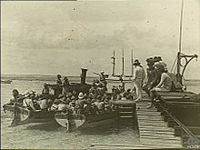
Queen Elizabeth and Prince Philip arrive at the Cocos Islands, April 1954.
See also
 In Spanish: Islas Cocos para niños
- Banknotes of the Cocos (Keeling) Islands
- Index of Cocos (Keeling) Islands-related articles
- Pearl Islands (Isla de Cocos, Panama; Cocos Island, Costa Rica).


