Kimmeridge facts for kids
Quick facts for kids Kimmeridge |
|
|---|---|
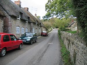 Kimmeridge main street |
|
| Population | 90 (2013 estimate) |
| OS grid reference | SY916798 |
| Civil parish |
|
| Unitary authority |
|
| Shire county | |
| Region | |
| Country | England |
| Sovereign state | United Kingdom |
| Post town | WAREHAM |
| Postcode district | BH20 |
| Dialling code | 01929 |
| Police | Dorset |
| Fire | Dorset |
| Ambulance | South Western |
| EU Parliament | South West England |
| UK Parliament |
|
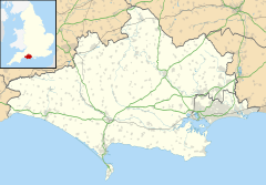
Kimmeridge is a small village and parish located on the Isle of Purbeck in Dorset, England. This area is a peninsula on the English Channel coast. Kimmeridge is about 4.5 miles (7 km) south of Wareham and 7 miles (11 km) west of Swanage. In 2013, about 90 people lived in the parish.
Kimmeridge is on the coast, and its shoreline is part of the Jurassic Coast. This famous area is a World Heritage Site because of its amazing geology. The coast here is also a Site of Special Scientific Interest, meaning it's protected for its natural features. The entire parish is part of the Dorset National Landscape, which is a special area known for its beautiful scenery.
Kimmeridge is famous for a type of rock called Kimmeridge Clay. This clay covers most of the parish. Inside the clay are layers of bituminous shale, which is a type of rock that can be used for fuel. People have tried to start industries here using this shale. An oil well has been working near Kimmeridge Bay since 1959. The village also gave its name to a period in Earth's history called the Kimmeridgian stage of the Late Jurassic period.
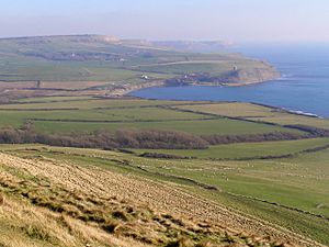
Kimmeridge Bay is a curved bay southwest of the village. It has low cliffs made of Kimmeridge clay. Below the cliffs, there's a large flat rock area called a wave-cut platform. This rocky shore has many rock pools, which are home to different sea creatures. Kimmeridge Bay is a popular spot for surfers and divers.
Contents
History of Kimmeridge Village
Ancient Times and Roman Use
Long ago, during the Iron Age and when the Romans were in Britain, people used the black bituminous shale found here. This shale was also called 'blackstone' or 'Kimmeridge coal'. They made ornaments and other items from it. For example, they used a special tool called a lathe to make armlets (bracelets) from the shale. This process left behind hard black discs. In the 1700s, people thought these discs were coins, so they called them 'coal money'. The Romans also burned the shale to heat seawater and make salt.
Medieval Settlements
In the Middle Ages, there were three small settlements in the parish: Kimmeridge, Little Kimmeridge, and Smedmore. Each had its own strip of land reaching from the coast to Smedmore Hill. Today, only Kimmeridge remains a village of any size.
Early Industrial Attempts
In the mid-1500s, Lord Mountjoy tried to make alum here, but his plan didn't work out. In the early 1600s, Sir William Clavell made several attempts to turn Kimmeridge into an industrial area. He tried boiling seawater to make salt, just like the Romans, using the shale as fuel.
Then, he tried to make alum again. However, he didn't have the right permission and got into trouble with other alum sellers in London. These sellers had special rights from King Charles I to be the only ones making alum in England. They took Clavell's property, demanded money, and even destroyed his workshops and stole his cattle. Clavell tried to fight this in court but lost.
He then tried to build a port at Kimmeridge. Finally, he tried to make glass. But all these plans failed. The pier he built for the port fell apart and was destroyed by a storm in 1745.
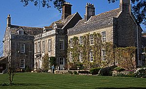
Sir William Clavell had Smedmore House built less than a mile southeast of Kimmeridge village. He called it his "little newe House" and moved in when it was finished in 1632. Before that, he lived at Barnston Manor nearby.
Shale Oil and Modern Times
In the mid-1800s, people started using the shale to get oil. In 1847, a special law allowed them to build roads and tramways to move the shale to Weymouth. There, it was processed into products like varnish, pitch, and dyes. Gas was also taken from the shale. However, both the oil and gas had a strong sulfur smell when burned. This made them not very good for home use.
The Royal National Lifeboat Institution had a lifeboat stationed at Kimmeridge from 1868 until 1896.
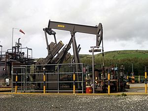
In 1959, an oil well was set up on the cliffs west of Kimmeridge Bay. It uses a "nodding donkey" pump to bring crude oil up from deep underground. In its early years, it pumped over 100,000 gallons (378,500 liters) per week. Between 1961 and 1974, it produced a total of 200,000 tonnes of oil.
How Kimmeridge is Governed
National and Local Elections
For elections to the UK parliament, Kimmeridge is part of the South Dorset parliamentary area.
For local government, Kimmeridge is in the Dorset unitary authority area. This is the highest level of local government here. Kimmeridge is part of the South East Purbeck ward, which chooses one person to represent it on the Dorset Council. At a lower level, Kimmeridge is a civil parish and has a Parish Meeting, where local people can discuss important issues.
Geography of Kimmeridge Parish
Location and Landscape
Kimmeridge village sits on a slope facing southwest, between the English Channel coast and a line of hills to the north and east. It's about 7 miles (11 km) west of Swanage, 4.5 miles (7 km) south of Wareham, and 15 miles (24 km) east of Weymouth.
The Kimmeridge civil parish includes the village and the land to its south and east. Its borders are marked by a stream, hills like Smedmore Hill and Swyre Head, and the coastline. Nearby parishes include Corfe Castle, Church Knowle, and Steeple. The western part of Kimmeridge Bay is actually in Steeple parish.
Protected Areas and Natural Beauty
Kimmeridge civil parish has several protected areas. Its coastline is part of the Jurassic Coast, a World Heritage Site since 2001. This site is important because of its unique geological features. The coast at Kimmeridge is also a Site of Special Scientific Interest.
The entire Kimmeridge parish is within the Dorset National Landscape (formerly "Area of Outstanding Natural Beauty"). This national title means the area's beautiful scenery is highly protected. All the buildings in Kimmeridge village are part of the Kimmeridge Conservation Area. This area was created in 1975 to protect the village's historic and interesting architecture.
Over 2,000 hectares (4,900 acres) of the coast and underwater area at Kimmeridge Bay are part of the Purbeck Marine Wildlife Reserve. This is the UK's oldest Voluntary Marine Nature Reserve. While it doesn't offer legal protection for wildlife, it has a visitor center near Kimmeridge Bay to teach people about the marine life.
Geology and Oil
The ground in Kimmeridge civil parish is mostly made of bedrock from the Late Jurassic period. On top of this, in many places, are younger deposits called Quaternary head deposits. The bedrock is mainly Kimmeridge clay. However, the top of Smedmore Hill and Swyre Head are made of Portland stone. Just below this stone is a thin layer of Portland sand.
Landslides from the Portland stone cover most of the steep slopes of the hills. Inside the Kimmeridge clay, there are layers of bituminous shale and dolomite. These form flat ledges in Kimmeridge Bay that you can see at low tide.
Kimmeridge gives its name to the Kimmeridgian stage, a part of the Jurassic period. This is because the cliffs here show these rock layers very well and contain many fossils. Kimmeridge is also the main place where the Jurassic age Kimmeridge Clay formation was first studied. This clay is found in southern England and is a source of oil and gas.
The Kimmeridge Oil Field is northwest of Kimmeridge Bay. On the cliff west of the village, there's a Perenco "nodding donkey" oil pump. It has been pumping oil continuously since the late 1950s, making it the oldest working oil pump in the UK. The well currently produces about 65 barrels of oil per day from rock layers about 1,150 feet (350 meters) below the cliff. The well has been working for so long because it's connected to a network of oil reserves. However, the amount of oil it produces is slowly decreasing each year. The oil is taken by tanker to the Perenco site at Wytch Farm and then piped to a main refinery.
Population of Kimmeridge
In 2013, the estimated population of Kimmeridge civil parish was 90 people.
In the 2001 census, Kimmeridge parish had 55 homes and a population of 110.
In the 2011 census, the results for Kimmeridge parish were combined with the nearby parishes of Steeple and Tyneham. This combined area had 101 homes, 87 households, and a total population of 206 people.
Important Buildings in Kimmeridge
In Kimmeridge parish, there are twenty-five buildings that Historic England has officially recognized as listed for their historical or architectural importance. None are Grade I (the highest level), but Smedmore House is Grade II*, which means it's a very important building.
Along the shore, just east of Kimmeridge Bay, there is a folly called Clavell Tower. A folly is a building built mainly for decoration. This tower inspired the novel The Black Tower by P.D. James. The tower was in danger of falling off the eroding cliff. So, it was carefully taken apart and rebuilt 115 feet (35 meters) further back from the cliff edge. You can even rent the tower for holidays!
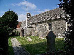
The parish church was mostly rebuilt in 1872. However, parts of it are much older, from the 12th century. The south door and parts of the west wall of the nave (the main part of the church) are still original. The south porch is from the early 13th century, and the bell-cote (where the bells hang) is from the 15th century.
The Etches Collection Museum
In 2014, £2.7 million was given to create a new museum in Kimmeridge, where the old village hall used to be. The whole project cost £5 million. This new building also has workshops for preserving items and a new village hall that can hold 120 people.
The museum is called the Museum of Jurassic Marine Life. It displays the Etches Collection, which has over 2,000 fossils. These fossils were collected over 30 years by a local resident named Steve Etches. The museum opened in October 2016.
Surfing at Kimmeridge Bay
Kimmeridge Bay is a place where people go surfing. It doesn't get big waves very often because it's not directly exposed to the large waves from the Atlantic Ocean. But when the conditions are right, it can have great waves.
Below the cliffs to the east is an area called 'The Ledges'. Here, waves break slowly to the left and right. The right-hand waves can go for 70 yards (64 meters) or more into the bay. To the west is 'Broad Bench'. This area is inside a Ministry of Defence firing range, so you can only go there when the range is open to the public.
See also
 In Spanish: Kimmeridge para niños


