
Kodaikanal facts for kids
Quick facts for kids
Kodaikanal
|
|
|---|---|
|
|
|
| Nickname(s):
Princess of Hill Stations
|
|

Kodaikanal
Location in Tamil Nadu
|
|
| Country | India |
| State | Tamil Nadu |
| District | Dindigul |
| Taluk | Kodaikanal |
| Established | 1845 |
| Government | |
| • Type | Municipality |
| • Body | Kodaikanal Municipality |
| Area | |
| • Total | 21.45 km2 (8.28 sq mi) |
| Elevation | 2,133 m (6,998 ft) |
| Population
(2011)
|
|
| • Total | 36,501 |
| Languages | |
| • Official | Tamil and English |
| Time zone | UTC+5:30 (IST) |
| PIN |
624101
|
| Telephone code | 04542 |
| Vehicle registration | TN-57, TN-94 |
| Precipitation | 1,650 mm (65 in) |
| Sex ratio | M 51% F 49% ♂/♀ |
| Literacy | 89.5% (2011) |
| Avg. summer temperature | 19.8 °C (67.6 °F) |
| Avg. winter temperature | 8.3 °C (46.9 °F) |


Kodaikanal is a beautiful hill station in the Dindigul district of Tamil Nadu, India. It sits high up in the Palani hills, which are part of the Western Ghats. The town is about 2,225 m (7,300 ft) above sea level.
Kodaikanal was started in 1845. People built it as a cool place to escape the hot summers and tropical diseases found in the plains below. Today, it is a very popular place for tourists and is known as the "Princess of Hill Stations." Most of the money made here comes from the hospitality industry, which means hotels, restaurants, and other services for visitors. In 2011, about 36,501 people lived in Kodaikanal.
Contents
- What's in a Name? The Meaning of Kodaikanal
- A Look Back: Kodaikanal's History
- Exploring Kodaikanal's Geography
- People and Population: Demographics of Kodaikanal
- Kodaikanal's Economy: How People Make a Living
- How Kodaikanal is Governed: Administration
- Getting Around: Transportation in Kodaikanal
- Learning in Kodaikanal: Education
- Fun Things to Do: Tourism and Recreation
- Protecting the Environment: Pollution Concerns
- Images for kids
- See also
What's in a Name? The Meaning of Kodaikanal
The name Kodaikanal comes from two Tamil words. Kodai means "gift," and kanal means "forest." So, Kodaikanal means "gift of the forest."
A Look Back: Kodaikanal's History
The Palani hills, where Kodaikanal is located, have a long history. Ancient Tamil writings called Sangam literature mention this mountainous area. It was known for its forests, lakes, and waterfalls. Trees like teak, bamboo, and sandalwood grew here.
The region was also home to the Palaiyar tribal people. They hunted, collected honey, and grew millet. A special flower called Kurinji grows only in these hills. It blooms only once every 12 years!
How Kodaikanal Became a Town
In 1821, a British officer named B. S. Ward explored the area. He described beautiful hills with a healthy climate. Later, in 1852, Major J. M. Partridge built the first house and settled here.

In 1863, an artificial lake was created, which is now Kodaikanal Lake. More people started to settle in Kodaikanal. In 1867, eucalyptus and wattle trees from Australia were brought and planted. In 1872, Lt. Coaker made a path along a steep ridge, which is now known as Coaker's Walk.
By the late 1800s, Kodaikanal became a regular summer getaway. American missionaries and European diplomats came here to escape the heat and diseases of the plains. The first observations at the Kodaikanal Solar Observatory began in 1901. By 1909, Kodaikanal had grown into a small town with houses, a post office, churches, schools, and shops. The main road to the hills was finished in 1914.
Exploring Kodaikanal's Geography
Kodaikanal is built on a plateau high up in the Palani Hills. It sits at about 2,225 metres (7,300 ft) above sea level. The town's center is the Kodaikanal Lake, which was made by people in 1863. This lake is about 5 kilometres (3.1 mi) around.
To the north, high hills slope down to villages. To the east, the hills gently slope down. To the south, there is a very steep drop-off that looks over the Cumbum valley. Many streams and waterfalls can be found around Kodaikanal.

Plants and Animals of Kodaikanal
Kodaikanal is home to many interesting plants and animals. In 1836, a botanist named Robert Wight found over 100 different plant types here. In 1861, Douglas Hamilton recorded 114 types of birds.

The natural plant life used to be mostly Meadows and grasslands on the hillsides, with dense forests called sholas in the valleys. When the British came, they planted many pine, wattle, and eucalyptus trees. These trees grew very well and replaced some of the native shola forests. You can also find many pear trees, and beautiful rhododendron and magnolia trees. The Kurinji flower, which blooms only once every 12 years, is special to this area.
Animals like Nilgiri Tahrs (a type of mountain goat), Indian elephants, Indian gaur (a type of wild cattle), and Flying squirrels live here. Many kinds of butterflies also fly around. To protect these animals and plants, the Government of Tamil Nadu created the Kodaikanal Wildlife Sanctuary in 2013. It covers over 700 km2 (270 sq mi). The lake also has different kinds of fish that were brought there.
Kodaikanal's Climate
Kodaikanal has a cool climate all year round because it is so high up. It gets a lot of rain, especially during the monsoon season.
| Climate data for Kodaikanal (1981–2010, extremes 1901–2012) | |||||||||||||
|---|---|---|---|---|---|---|---|---|---|---|---|---|---|
| Month | Jan | Feb | Mar | Apr | May | Jun | Jul | Aug | Sep | Oct | Nov | Dec | Year |
| Record high °C (°F) | 25.4 (77.7) |
24.7 (76.5) |
26.7 (80.1) |
26.1 (79.0) |
27.8 (82.0) |
25.1 (77.2) |
23.9 (75.0) |
22.9 (73.2) |
22.8 (73.0) |
22.2 (72.0) |
23.4 (74.1) |
24.5 (76.1) |
27.8 (82.0) |
| Mean daily maximum °C (°F) | 18.4 (65.1) |
19.4 (66.9) |
20.7 (69.3) |
21.1 (70.0) |
21.4 (70.5) |
19.6 (67.3) |
18.5 (65.3) |
18.5 (65.3) |
18.8 (65.8) |
18.0 (64.4) |
17.0 (62.6) |
17.3 (63.1) |
19.1 (66.4) |
| Mean daily minimum °C (°F) | 8.6 (47.5) |
8.9 (48.0) |
10.5 (50.9) |
11.9 (53.4) |
12.8 (55.0) |
12.2 (54.0) |
11.7 (53.1) |
11.6 (52.9) |
11.4 (52.5) |
11.0 (51.8) |
10.1 (50.2) |
9.0 (48.2) |
10.8 (51.4) |
| Record low °C (°F) | 2.7 (36.9) |
3.8 (38.8) |
4.4 (39.9) |
6.1 (43.0) |
7.8 (46.0) |
5.0 (41.0) |
8.6 (47.5) |
8.3 (46.9) |
8.3 (46.9) |
5.6 (42.1) |
3.9 (39.0) |
2.8 (37.0) |
2.7 (36.9) |
| Average rainfall mm (inches) | 37.9 (1.49) |
37.5 (1.48) |
55.7 (2.19) |
127.5 (5.02) |
126.4 (4.98) |
89.8 (3.54) |
111.6 (4.39) |
128.5 (5.06) |
216.9 (8.54) |
259.0 (10.20) |
239.9 (9.44) |
137.5 (5.41) |
1,568.3 (61.74) |
| Average rainy days | 2.3 | 1.7 | 3.6 | 7.5 | 8.9 | 8.7 | 9.2 | 8.7 | 12.6 | 14.2 | 11.1 | 6.6 | 94.9 |
| Average relative humidity (%) (at 17:30 IST) | 73 | 70 | 67 | 78 | 82 | 86 | 86 | 86 | 87 | 87 | 87 | 79 | 81 |
| Mean monthly sunshine hours | 248.0 | 220.4 | 235.6 | 210.0 | 192.2 | 117.0 | 99.2 | 114.7 | 114.0 | 124.0 | 132.0 | 158.1 | 1,965.2 |
| Mean daily sunshine hours | 8.0 | 7.8 | 7.6 | 7.0 | 6.2 | 3.9 | 3.2 | 3.7 | 3.8 | 4.0 | 4.4 | 5.1 | 5.4 |
| Source: India Meteorological Department (sun 1971–2000) | |||||||||||||
People and Population: Demographics of Kodaikanal
In 2011, Kodaikanal had a population of 36,501 people. For every 1,000 males, there were 1,004 females, which is a good balance. About 3,893 children were under six years old.
Most people in Kodaikanal can read and write. The average literacy rate was about 79.78%. The main languages spoken are Tamil and English. The population includes people from different religions, with Hindus, Christians, and Muslims being the largest groups.
Kodaikanal's Economy: How People Make a Living
The main way Kodaikanal makes money is through tourism. In 2009, about 3.2 million tourists visited the town. Every year, special preparations are made for the busy tourist season in summer. Roads are changed to one-way streets to help with traffic. Extra police officers are brought in to keep tourists safe and protect local businesses.
Farmers in nearby villages grow crops like plums, pears, peppers, carrots, cauliflower, cabbage, garlic, and onions. They use a method called terrace farming. These crops are then taken by truck to the market.
How Kodaikanal is Governed: Administration
Kodaikanal is managed by the Kodaikanal municipality. This local government was started in 1899. It has grown over the years and is now a Special Grade Municipality. The Municipal Council has 24 different areas, or wards.
The town has a government hospital and some private health centers. These places help people with their health needs.
Getting Around: Transportation in Kodaikanal
In the past, getting to Kodaikanal was quite an adventure! Early travelers would go about 50 kilometers (31 mi) by bullock cart. Then, they would walk, ride horses, or be carried in palanquins for the last 18 kilometers (11 mi) up the hill.

In 1854, a better path was built for horses. This path was later extended to Kodaikanal in 1878. A motor-friendly road was finally completed in 1914 and opened to the public in 1916. This road is now called SH-156.
Today, you can reach Kodaikanal mainly by road through Palani and Batlagundu. State-owned buses also offer services. The nearest train stations are Palani (64 kilometres or 40 miles) and Kodaikanal Road (80 kilometres or 50 miles). The closest major train station is Madurai Junction (114 kilometres or 71 miles). The nearest airports are Madurai International Airport (115 kilometres or 71 miles) and Coimbatore International Airport (170 kilometres or 110 miles). These airports have flights to major cities in India and some international places.
Learning in Kodaikanal: Education
Kodaikanal is part of the Batlagundu educational district. The town has a government school and many private schools for children. There are also a few colleges, including the Kodaikanal Christian College and Mother Teresa Women's University.
Fun Things to Do: Tourism and Recreation
Kodaikanal has many places to visit and activities to enjoy.
Clubs and Organizations
Several clubs and groups in Kodaikanal work for social, charity, and environmental goals. Some well-known clubs include the Kodaikanal Boat Club (started in 1890) and the Kodaikanal Golf Club (started in 1895). There are also groups like the Kodaikanal People Development Group (KOPDEG), which helps women find jobs and sell their products. The Potter's Shed sells pottery made locally. Groups like the Kodaikanal Lake Protection Council help protect the environment.
Places of Worship
You can find many Hindu temples, mosques, and churches in Kodaikanal.
- The Kuzhanthai Velappar temple is very old, believed to be built thousands of years ago. It has a special idol of the god Murugan.
- The Kurinji Andavar Temple is named after the rare Kurinji flower. It was built in 1924 and is also dedicated to Lord Murugan.
- La Saleth Church is a church dedicated to Virgin Mary. It is located near Coaker’s Walk.
Popular Tourist Spots

- Kodaikanal Lake: This is an artificial lake shaped like a star, built in 1863. It's the most famous landmark in Kodaikanal. You can rent rowboats and pedalos here.
- Berijam Lake: Another artificial lake, about 22 km (14 mi) from Kodaikanal.
- Bear Shola Falls: A waterfall about 3 km (1.9 mi) from Kodaikanal, hidden inside the forest. The amount of water depends on the monsoon rains.
- Bryant Park: A beautiful park next to Kodaikanal Lake. It's named after the British officer who started it. An annual flower show is held here in May.
- Coaker's Walk: A 1 km (0.62 mi) long walkway built in 1872. It offers amazing views of the valley and plains below.
- Dolphin Nose: A viewpoint that gives a wide view of the valley. You can reach it by a 3 km (1.9 mi) trek.
- Green Valley View: Located 5 km (3.1 mi) from Kodaikanal Lake, this spot offers a view of the Vaigai Dam below.
- Pine Forests: In 1906, pine trees were planted to grow valuable timber. Now, these Pine forests are a popular place for tourists to visit.
- Pillar Rocks: These are two tall rock formations, 122 m (400 ft) high, about 7 km (4.3 mi) from Kodaikanal Lake.
- Shenbaganur Museum: About 5 km (3.1 mi) from the lake, this museum has an orchid garden and an archaeological section.
- Silver Cascade: A 100 ft (30 m) waterfall formed by the water overflowing from Kodaikanal Lake. It's about 8 km (5.0 mi) from town.

- Guna Caves: Also known as Devil's Kitchen, these are deep caves between the giant Pillar Rocks. They became famous after a Tamil movie called Gunaa.
Kodaikanal Solar Observatory
The Kodaikanal Solar Observatory is about 6 kilometres (3.7 mi) from the bus stand. It is the highest point near Kodaikanal, at 2,343 metres (7,687 ft) above sea level. Scientists started observing the sun here in 1901. A former director, John Evershed, discovered something special about how gases move on the sun, now called the Evershed effect. The observatory also has a science museum about space and offers public tours. You can even look at the night sky through a telescope!
Protecting the Environment: Pollution Concerns
To protect Kodaikanal's delicate environment, plastic bags have been banned.
In 1983, a factory that made mercury thermometers moved to Kodaikanal. This factory was owned by a company called Unilever. In 2001, the factory was closed because of concerns about mercury pollution. Mercury from the factory had spread into the air and water, affecting large areas of Kodaikanal and the nearby forests. Experts believed this pollution could last for hundreds of years.
A government committee in 2011 estimated that a lot of mercury might have been released into the air and disposed of as waste. After many years of legal discussions, Unilever agreed in 2016 to pay money to the workers who were affected by the mercury. Studies are now being done to figure out the best way to clean up the contaminated soil.
Images for kids
-
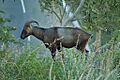
Nilgiri Tahrs were seen in the grasslands.

See also
 In Spanish: Kodaikanal para niños
