Kokkola facts for kids
Quick facts for kids
Kokkola
|
|||
|---|---|---|---|
|
Town
|
|||
| Kokkolan kaupunki Karleby stad |
|||
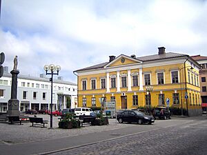
Old Kokkola town hall
|
|||
|
|||
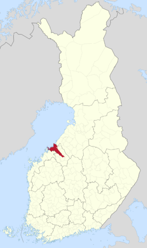
Location of Kokkola in Finland
|
|||
| Country | |||
| Region | Central Ostrobothnia | ||
| Sub-region | Kokkola sub-region | ||
| Charter | 1620 | ||
| Area
(2018-01-01)
|
|||
| • Total | 2,730.80 km2 (1,054.37 sq mi) | ||
| • Land | 1,446.27 km2 (558.41 sq mi) | ||
| • Water | 1,286.61 km2 (496.76 sq mi) | ||
| Area rank | 46th largest in Finland | ||
| Population
(2023-12-31)
|
|||
| • Total | 48,295 | ||
| • Rank | 22nd largest in Finland | ||
| • Density | 33.39/km2 (86.5/sq mi) | ||
| Population by native language | |||
| • Finnish | 83% (official) | ||
| • Swedish | 12% | ||
| • Others | 5% | ||
| Population by age | |||
| • 0 to 14 | 18.6% | ||
| • 15 to 64 | 58.8% | ||
| • 65 or older | 22.6% | ||
| Time zone | UTC+02:00 (EET) | ||
| • Summer (DST) | UTC+03:00 (EEST) | ||
Kokkola is a lively town in Finland. It's the main city of the Central Ostrobothnia region. You can find it on the west coast of Finland, right by the Gulf of Bothnia.
About 48,000 people live in Kokkola. The wider Kokkola area has around 54,000 residents. It's one of Finland's most populated cities.
Kokkola covers a large area, including land and water. It's a bilingual city, meaning both Finnish and Swedish are official languages. Most people speak Finnish, but a good number speak Swedish too. Kokkola celebrated its 400th birthday in 2020!
Contents
Understanding Kokkola's Name
How Kokkola Got Its Name
In older Swedish records, Kokkola was called Karlabi. Later, it was known as Gamlakarleby in Swedish. This changed in 1977 when the nearby area of Kaarlela joined Kokkola. Then, the city took on the Swedish name Karleby.
The word gamla means "old." Karl can mean "Charles" or simply "man." By means "village." So, the old name could mean "old village of Charles" or "old man village." The city's founder, King Gustav II Adolf, might have named it after his father, King Karl IX of Sweden.
The Finnish name, Kokkola, might come from "Kokkolahti," a bay where the town is located. Some say sea eagles (called merikotka or kokko in Finnish) used to live there. Another idea is that the name comes from old signal fires (also called kokko). These fires warned people about enemies.
Kokkola's Coat of Arms
Kokkola's coat of arms comes from the city's official seal from 1620. This was when the city was first founded. The design shows a tar barrel with three burning flames. This symbolizes the tar burning and trade that were very important to Kokkola's history. The coat of arms was designed by Olof Eriksson and Into I. Suominen.
Kokkola's Past
Early History and Trade
King Gustav II Adolf of Sweden officially made Kokkola a town in 1620. At that time, Finland was part of the Swedish Empire. Kokkola is one of Finland's oldest towns. The king chose the tar barrel for the city's seal because Kokkola was a major port for shipping tar.
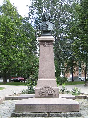
Anders Chydenius (1729-1803) was a famous politician in Sweden. He strongly believed in economic freedom. In 1765, thanks to his efforts, Kokkola gained special trading rights. This allowed the city to trade freely with other countries. Kokkola also became a big center for shipbuilding. Because of the tar trade and shipbuilding, Kokkola was once one of the richest towns in Finland!
The Skirmish of Halkokari
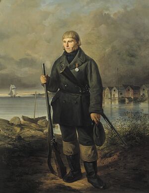
An interesting event happened in Kokkola on June 7, 1854. This was during the Åland War, which was part of the Crimean War. British Royal Marines tried to land in Kokkola. But local defenders, using hunting rifles, fought them off. They were helped by troops and cannons.
One of the smaller British boats was captured by the defenders. This boat is still in Kokkola today! You can see it in Kokkola's English Park. The city council has said no to requests from the United Kingdom to return the boat. The British government still pays a small amount each year to the local church. This money helps take care of the graves of nine Royal Marines who died in the fight.
Recent Changes to the City
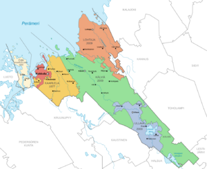
Until 1933, most people in Kokkola spoke Swedish. In 1977, the nearby area of Kaarlela joined Kokkola. Then, in 2009, the towns of Lohtaja, Kälviä, and Ullava also became part of Kokkola.
Kokkola's Location and Environment
Where is Kokkola?
Kokkola is the main city of the Central Ostrobothnia region. It's located on the coast of the Gulf of Bothnia. This gulf is the northernmost part of the Baltic Sea.
Other big cities nearby include Vaasa, which is about 121 kilometers southwest. Oulu is about 198 kilometers northeast. Finland's capital, Helsinki, is about 483 kilometers to the south. Kokkola's neighbors include Kalajoki, Kannus, Toholampi, Halsua, Kaustinen, Kronoby, and Larsmo.
The Landscape Around Kokkola
The area around Kokkola is mostly flat. This is typical for the Ostrobothnia region. Many rivers flow through the land. The largest river is Perhonjoki, which flows into the Gulf of Bothnia north of Kokkola.
Did you know that the land in Kokkola is still rising? It rises about 8.8 millimeters each year! This means that when the town was founded, many parts of what is now land were actually underwater.
Kokkola's Climate
Kokkola has a climate with cold winters and mild summers. Here's a look at the average temperatures:
| Climate data for Kokkola-Pietarsaari airport, normals 1991-2020, extremes 1961 - present | |||||||||||||
|---|---|---|---|---|---|---|---|---|---|---|---|---|---|
| Month | Jan | Feb | Mar | Apr | May | Jun | Jul | Aug | Sep | Oct | Nov | Dec | Year |
| Record high °C (°F) | 9.1 (48.4) |
10.4 (50.7) |
13.9 (57.0) |
21.4 (70.5) |
29.6 (85.3) |
32.6 (90.7) |
34.3 (93.7) |
31.3 (88.3) |
27.6 (81.7) |
20.9 (69.6) |
12.3 (54.1) |
8.4 (47.1) |
34.3 (93.7) |
| Mean daily maximum °C (°F) | −3.2 (26.2) |
−3.2 (26.2) |
0.9 (33.6) |
7.4 (45.3) |
14.1 (57.4) |
18.5 (65.3) |
21.7 (71.1) |
19.6 (67.3) |
14.2 (57.6) |
6.8 (44.2) |
1.8 (35.2) |
−1.0 (30.2) |
8.1 (46.6) |
| Daily mean °C (°F) | −6.2 (20.8) |
−6.9 (19.6) |
−3.3 (26.1) |
2.4 (36.3) |
8.3 (46.9) |
13.5 (56.3) |
16.4 (61.5) |
14.6 (58.3) |
9.6 (49.3) |
3.8 (38.8) |
−0.5 (31.1) |
−3.9 (25.0) |
4.0 (39.2) |
| Mean daily minimum °C (°F) | −10.1 (13.8) |
−10.6 (12.9) |
−7.4 (18.7) |
−2.2 (28.0) |
2.4 (36.3) |
7.6 (45.7) |
11.1 (52.0) |
9.5 (49.1) |
5.2 (41.4) |
0.5 (32.9) |
−3.1 (26.4) |
−6.7 (19.9) |
−0.3 (31.4) |
| Record low °C (°F) | −40.5 (−40.9) |
−41.5 (−42.7) |
−33.4 (−28.1) |
−22.2 (−8.0) |
−10.1 (13.8) |
−3.6 (25.5) |
−0.5 (31.1) |
−3.2 (26.2) |
−8.6 (16.5) |
−22.2 (−8.0) |
−32.2 (−26.0) |
−37.9 (−36.2) |
−41.5 (−42.7) |
| Source: FMI climatological normals for Finland 1991–2020 | |||||||||||||
| Climate data for Kokkola Tankar (1991–2020 normals, extremes 1996- present) | |||||||||||||
|---|---|---|---|---|---|---|---|---|---|---|---|---|---|
| Month | Jan | Feb | Mar | Apr | May | Jun | Jul | Aug | Sep | Oct | Nov | Dec | Year |
| Record high °C (°F) | 6.0 (42.8) |
6.3 (43.3) |
11.1 (52.0) |
18.5 (65.3) |
23.3 (73.9) |
28.6 (83.5) |
30.2 (86.4) |
30.3 (86.5) |
22.9 (73.2) |
18.4 (65.1) |
11.0 (51.8) |
7.7 (45.9) |
30.3 (86.5) |
| Mean daily maximum °C (°F) | −2.1 (28.2) |
−3.1 (26.4) |
0.1 (32.2) |
4.3 (39.7) |
9.8 (49.6) |
14.9 (58.8) |
18.7 (65.7) |
17.9 (64.2) |
13.3 (55.9) |
7.3 (45.1) |
2.8 (37.0) |
0.1 (32.2) |
7.0 (44.6) |
| Daily mean °C (°F) | −4.5 (23.9) |
−5.8 (21.6) |
−3.1 (26.4) |
1.1 (34.0) |
6.1 (43.0) |
11.5 (52.7) |
15.7 (60.3) |
15.3 (59.5) |
11.1 (52.0) |
5.7 (42.3) |
1.2 (34.2) |
−1.8 (28.8) |
4.4 (39.9) |
| Mean daily minimum °C (°F) | −7.0 (19.4) |
−8.5 (16.7) |
−5.5 (22.1) |
−1.2 (29.8) |
3.9 (39.0) |
9.5 (49.1) |
13.6 (56.5) |
13.2 (55.8) |
9.1 (48.4) |
3.9 (39.0) |
−0.6 (30.9) |
−3.9 (25.0) |
2.2 (36.0) |
| Record low °C (°F) | −30.2 (−22.4) |
−28.3 (−18.9) |
−23.7 (−10.7) |
−16.2 (2.8) |
−4.8 (23.4) |
1.8 (35.2) |
7.3 (45.1) |
6.5 (43.7) |
2.0 (35.6) |
−5.8 (21.6) |
−17.7 (0.1) |
−25.4 (−13.7) |
−30.2 (−22.4) |
| Average relative humidity (%) | 88 | 88 | 85 | 83 | 80 | 80 | 82 | 82 | 83 | 85 | 89 | 89 | 85 |
| Source 1: FMI normals 1991-2020 | |||||||||||||
| Source 2: Record highs and lows | |||||||||||||
People of Kokkola
Population Size
Kokkola has 48,295 residents. This makes it the 22nd most populated city in Finland. The wider Kokkola region, including Kannus, has 53,541 people. About 5.1% of Kokkola's population has a foreign background. This is a bit lower than the average for all of Finland.
| Year | Population |
|---|---|
| 1990 |
43,267
|
| 1995 |
44,441
|
| 2000 |
44,182
|
| 2005 |
44,627
|
| 2010 |
46,260
|
| 2015 |
47,570
|
| 2020 |
47,772
|
Languages Spoken
Population by mother tongue (2023) Finnish (83.0%) Swedish (12.0%) Russian (0.6%) Arabic (0.4%) English (0.4%) Ukrainian (0.3%) Chinese (0.3%) Other (3.3%)
Kokkola is a bilingual city. Both Finnish and Swedish are official languages. Most people, about 83.0%, speak Finnish as their first language. About 12.0% of the population speaks Swedish.
About 5% of residents speak a language other than Finnish or Swedish. Many people in Kokkola can speak more than one language. This is because English and Swedish (or Finnish for Swedish speakers) are required subjects in school.
Kokkola is the northernmost place on Finland's west coast where many Swedish-speakers live. The city center is bilingual. However, many villages around Kokkola mostly speak Swedish. The areas that joined Kokkola in 2009 are mainly Finnish-speaking.
At least 30 different languages are spoken in Kokkola. The most common foreign languages are Russian, Arabic, English, and Chinese.
People from Other Countries
| Population by country of birth (2022) | ||
| Nationality | Population | % |
|---|---|---|
| 45,626 | 95.0 | |
| 435 | 0.9 | |
| 197 | 0.4 | |
| 135 | 0.3 | |
| 115 | 0.2 | |
| 91 | 0.2 | |
| 89 | 0.2 | |
| 71 | 0.1 | |
| 65 | 0.1 | |
| 64 | 0.1 | |
| 53 | 0.1 | |
| Other | 1,065 | 2.2 |
As of As of 2023[update], about 2,485 people in Kokkola had a background from another country. This is about 5.1% of the population. Most foreign-born residents came from Sweden, the former Soviet Union, Thailand, and China. The number of new residents from other countries is growing. This will increase the number of foreign residents in Kokkola in the future.
Religions in Kokkola
In 2023, the Evangelical Lutheran Church was the largest religious group in Kokkola. About 72.5% of the population belonged to this church. Other religious groups made up 2.1% of the population. About 25.4% of the people in Kokkola did not have a religious affiliation.
Kokkola's Economy
Kokkola is the biggest city and capital of the Central Ostrobothnia region. The chemical industry is a very important employer here. There's a large industrial area and the city's port in Ykspihlaja.
Companies like OMG have a cobalt plant. The Freeport/Umicore refinery is the only big cobalt refinery outside China. Boliden has a zinc plant. Kemira, a chemical company, built an industrial park that is now used by several businesses. Other industries in Kokkola include metalworking, casting, textiles, plastics, food, and carpentry.
The biggest employers in Kokkola (as of 2011) are:
- The city of Kokkola (around 2,350 employees)
- Central Ostrobothnian Joint Municipal Authority for Social and Health Services (Soite) (2,500 employees)
- Boliden Kokkola Oy (zinc) (500 employees)
- Umicore (cobalt) (420 employees)
- KPO group (retail) (400 employees)
- Halpa-Halli (retail) (300 employees)
- CABB Oy (fine chemicals) (200 employees)
The Port of Kokkola
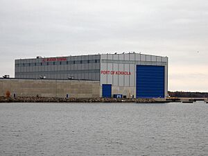
The Port of Kokkola is located in Ykspihlaja, about 5 kilometers from the city center. It's one of the busiest ports in Finland! Things like oil, ore, and limestone are brought in. Refined products and timber are sent out. Iron ore is also moved through the port.
Shopping in Kokkola
The Chydenia Shopping Center opened in 2006. It's right in the center of Kokkola. About 2 million people visit this shopping center every year!
Getting Around Kokkola
Kokkola is on the coast of the Gulf of Bothnia. The main road, European route E8 (Finnish highway 8), goes through the city. This road connects Oulu and Turku through Vaasa. Finnish highway 28 starts in Kokkola and goes to Kajaani. Finnish highway 13 also starts here and goes all the way to the Russian border.
The beautiful '7 Bridges Archipelago Road' (road 749) runs along the coast between Kokkola and Jakobstad.
Air and Rail Travel
The Kokkola-Pietarsaari Airport is about 22 kilometers from Kokkola, in Kronoby.
The Kokkola railway station is a stop on the main railway line. You can take a train from here to Helsinki, going through Tampere and Seinäjoki. Fast Pendolino trains also run on this route.
Currently, there are no passenger ferries from Kokkola.
Culture and Fun in Kokkola
Kokkola is home to the famous Ostrobothnian Chamber Orchestra. This orchestra was started in 1972 by conductor Juha Kangas.
Interesting Buildings and Places
- Neristan: This is an old part of downtown Kokkola with many wooden houses. These houses have been there for hundreds of years! Today, you can find restaurants, cafes, small shops, and even places to stay for tourists. It's a charming area to explore.
- Tankar Island: This lighthouse island is in the outer archipelago, about 18 kilometers northwest of Kokkola. The lighthouse is still used today. On the island, you can also find a museum about seal-hunting, a tower for bird-watching, and many nature trails. You can even stay overnight! It's easy to get there by ferry from Kokkola.
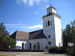
- Kaarlela Church: The stone Evangelical-Lutheran Church of Kaarlela has been a landmark since 1550. It's a popular place for weddings and concerts. Next to the church, there's a local history museum. It has an old farmhouse, a smithy, a tannery, and other historic buildings.
- K.H. Renlund Museum: This museum is dedicated to Karl Herman Renlund. He gave his large art collection to the town of Kokkola. The museum has temporary exhibits and a gift shop. Next to it is the Pedagogio, Finland's oldest wooden school building, built in 1696. The Lassander House nearby shows what a merchant's home looked like in the 1700s.
Sports in Kokkola
In winter, Kokkola has 20 skiing tracks, totaling 150 kilometers!
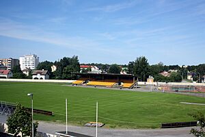
Kokkola is home to the ice hockey club Hermes. They play in Finland's second-highest league. There are also two soccer clubs: Kokkolan Palloveikot (KPV), which plays in the second-highest league, and Gamlakarleby Bollklubb (GBK), which plays in the third-highest league.
Kokkola's volleyball team, Kokkolan Tiikerit, plays in Finland's top volleyball league and has won national championships for men. Sailing clubs include Gamlakarleby Segelförening, Kokkolan Purjehtijat, and Kokkolan venekerho. There's even an American football team called Karleby Goats. They play in Finland's third-highest American football league.
Learning in Kokkola
Kokkola has many preschools. Some offer children a bilingual education from a young age, often Finnish-English or Finnish-Swedish. There are 25 Finnish-speaking schools and 8 Swedish-speaking schools.
There are also three secondary schools for Finnish-speaking students and one for Swedish-speaking students. Some schools offer vocational education and training.
The Chydenius-Institution of Kokkola is a group of universities working together. They offer teaching and research, especially for adult education. They have open university studies and further training for professionals in fields like education, social services, and health services.
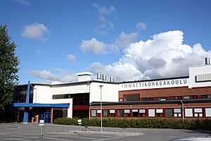
Centria University of Applied Sciences (Centria ammattikorkeakoulu in Finnish) is also in Kokkola. It's an international school that offers three different bachelor's degree programs in English, as well as programs in Finnish.
Famous People from Kokkola
- Anders Chydenius (1729–1803), a Lutheran priest and politician.
- Otto Donner (1835–1909), a linguist, professor, and politician.
- Juho Kuosmanen (born 1979), a film director and screenwriter.
- Joonas Sammalmaa (born 1991), a professional ice hockey player.
Kokkola's Sister Cities
Kokkola is twinned with 15 cities around the world:
 Härnösand, Sweden
 Mörbylånga, Sweden
 Ullånger, Sweden
 Averøy, Norway
 Kristiansund, Norway
 Fredericia, Denmark
 Ambla, Estonia
 Järva-Jaani, Estonia
 Marijampolė, Lithuania
 Boldog, Hungary
 Hatvan, Hungary
 Ratingen, Germany
 Fitchburg, United States
 Greater Sudbury, Canada
 Fushun, China
See also
 In Spanish: Kokkola para niños
 | Sharif Bey |
 | Hale Woodruff |
 | Richmond Barthé |
 | Purvis Young |


