
Lambeth facts for kids
Quick facts for kids Lambeth |
|
|---|---|
 The waterfront of Lambeth including the International Maritime Organization and the former HQ of the London Fire Brigade |
|

Lambeth
|
|
| Population | 9,675 (Bishop's ward 2011 census) |
| OS grid reference | TQ305785 |
| • Charing Cross | 1 mi (1.6 km) N |
| London borough | |
| Ceremonial county | Greater London |
| Region | |
| Country | England |
| Sovereign state | United Kingdom |
| Post town | LONDON |
| Postcode district | SE1 |
| Dialling code | 020 |
| Police | Metropolitan |
| Fire | London |
| Ambulance | London |
| EU Parliament | London |
| UK Parliament |
|
| London Assembly |
|
Lambeth is a neighbourhood in South London, England. It is part of the London Borough of Lambeth. Lambeth is about 1 mile (1.6 km) south of Charing Cross. It sits across the River Thames from the Palace of Westminster.
Lambeth was once an old parish in the county of Surrey. In the past, it grew slowly around Lambeth Palace. By the time of the Victorian era, London was expanding quickly. Lambeth became a busy area with many factories, shops, and homes close together. After World War II, much of Lambeth changed. In recent years, more tall buildings have been built here.
Today, Lambeth is home to the International Maritime Organization. It also has one of the largest communities of Portuguese-speaking people in the UK. Portuguese is the second most common language spoken in Lambeth after English.
Contents
History of Lambeth
What's in a Name?
The name Lambeth comes from old records. In 1062, it was called Lambehitha. This means 'landing place for lambs'. Later, in 1255, it was called Lambeth. The name likely refers to a harbour where lambs were brought by boat.
Lambeth in Medieval Times
The land of Lambeth has belonged to the Archbishop of Canterbury since at least 1190. The Archbishops helped develop the area. Archbishop Hubert Walter built Lambeth Palace in 1197. This palace was important for two international agreements in the 1200s. These were the Treaty of Lambeth 1217 and the Treaty of Lambeth 1212.
Edward, the Black Prince, a famous prince, lived in Lambeth in the 1300s. He owned land that was not part of the Archbishop's estate. This included the area of Kennington. Even today, much of the land in Lambeth is owned by the Royal family. It is part of the Duchy of Cornwall estate.
Crossing the River
Lambeth Palace is right across the River Thames from the Palace of Westminster. In the past, people crossed the river between them using a horse ferry. Until 1750, you could only cross the river from Lambeth by ferry or by walking through shallow water (fords).
The northern part of Lambeth used to be marshland. This area was known as Lambeth Marshe. It was drained in the 1700s. The street name Lower Marsh reminds us of this history. After Westminster Bridge opened in 1750, more bridges like Blackfriars Bridge, Vauxhall Bridge, and Lambeth Bridge were built. This led to new main roads through Lambeth.
Before the 1700s, Lambeth was mostly countryside. It was outside central London. But it started to grow with places like taverns and theatres. The growth of transport and new industries changed the area a lot.
Growth and Change
Lambeth's population grew quickly in the 1700s and 1800s. Many people were poor. So, Lambeth opened a parish workhouse in 1726. This was a place where poor people could live and work.
The Royal Doulton Pottery company had its main factory in Lambeth for many centuries. They made famous pottery here. The factory closed in 1956. However, the old Doulton offices on Black Prince Road are still there. They are a listed building with beautiful original tiles.
Between 1801 and 1831, Lambeth's population tripled. It grew from about 87,000 to over 105,000 in just ten years (1831-1841). The railway arrived in Lambeth in the 1840s. The London and South Western Railway was extended to the new Waterloo station. This station opened in 1848. The area around the station and Lower Marsh became known as Waterloo. It became a separate area from Lambeth itself.
The Lambeth Ragged School was built in 1851. It helped educate children from poor families. Part of this school building still exists today. It is now the Beaconsfield Gallery. The Beaufoy Institute was also built in 1907. It offered technical education for local people.
Local Government
Lambeth was once a large parish called Lambeth St Mary. It stretched from the River Thames in the north to areas like Brixton and West Norwood in the south. In 1889, Lambeth became part of the County of London. The parish was reformed in 1900 to become the Metropolitan Borough of Lambeth.
In 1965, local government changed again. The areas of Streatham and Clapham joined Lambeth. This formed the modern London Borough of Lambeth. The current mayor of the borough is Annie Gallop (as of May 2021).
Modern Lambeth
Lambeth Walk and Lambeth High Street used to be busy shopping streets. Today, they are mostly residential. Lambeth Walk had a market for many years. By 1938, it had 159 shops.
Much of Lambeth was badly damaged during the Second World War. For example, the Victorian Swimming Baths were completely destroyed in 1945. A V-2 rocket hit the street, killing 37 people.
In 1948, the first group of immigrants from the Caribbean arrived from Jamaica on the Windrush ship. Many of them settled in areas like Brixton and Clapham.
Today, Lambeth is a very diverse area. It has a strong Afro-Caribbean community. Other large groups include Africans, South Asians, and Chinese. These groups make up one-third of Lambeth's population. It is a very busy area with many young people.
Governance
Lambeth is part of the Vauxhall area for national elections. At the 2019 General Election, Florence Eshalomi became the Member of Parliament (MP) for Vauxhall. She is from the Labour Party.
Important Buildings and Churches
.jpg)
The church of St Mary-at-Lambeth is the oldest building still standing in Lambeth. The oldest part of any structure is the crypt of Lambeth Palace. St Mary-at-Lambeth has been around since before the Normans arrived. It was rebuilt between 1374 and 1377. Only the tower is original today. The rest of the church was rebuilt by 1852. The church stopped being used for services in 1972. Since 1977, it has been home to the Garden Museum.
Lambeth Palace is the official home of the Archbishop of Canterbury. Archbishops have lived here since the early 1200s. The oldest parts of the palace are from the 1200s. These include Langton's Chapel and its crypt. They were damaged in the Second World War but have been repaired. Morton's Tower, the main entrance, was built in 1490. The Great Hall holds the huge collection of books from the Lambeth Palace Library.
The Albert Embankment was finished in 1869. It was built by engineer Sir Joseph Bazalgette. This embankment forms the edge of Lambeth along the river. It was built to protect low-lying areas from floods. It also created a new road to avoid busy local streets.
On the Albert Embankment is the special building for the International Maritime Organization (IMO). The IMO is part of the United Nations. It helps make rules for shipping around the world. Queen Elizabeth II officially opened the building in 1983. The front of the building has a huge bronze sculpture. It looks like the front of a ship with a sailor looking out.
From 1937 to 2007, the main office of the London Fire Brigade was in Lambeth. This building is also on Albert Embankment. It was built in an Art Deco style. It is still an active fire station today.
The Lambeth Mission is a church that combines Methodist and Anglican traditions. It is on Lambeth Road. The original church was founded in 1739. But it was destroyed by a bomb in the Second World War. A new church was built in 1950 and is still used today.
The Beaconsfield gallery is a public art gallery in Lambeth. It opened in 1995. It shows temporary art exhibitions and offers art classes. Morley College is a college for adult education. It was founded in the 1880s. It has buildings in both Lambeth and Southwark.
Lambeth in Books
From 1790 to 1800, the famous poet William Blake lived in North Lambeth. In his long poem Milton: A Poem in Two Books, the poet John Milton travels to Lambeth. He enters Blake's foot, inspiring Blake to create art.
Liza of Lambeth was the first novel by W. Somerset Maugham. It tells the story of a young factory worker's life and loves in Lambeth.
Thyrza, a novel by George Gissing from 1887, is set in Lambeth during the late Victorian era. It focuses on streets like Newport Street and Lambeth Walk. Gissing wanted the novel to show the "spirit of London working-class life." The story is about Walter Egremont, who gives literature lectures to workers.
Geography
Parks and Green Spaces
Lambeth has several public parks and gardens. Old Paradise Gardens is a park on Lambeth High Street. It used to be a burial ground. A memorial stone marks where a watch-house once stood.
Lambeth Walk Open Space is a small park to the east of Lambeth. It has open areas and play spaces. Pedlars' Park is another small public park in Lambeth. It was created in 1968 on the site of an old school. Archbishop's Park is open to the public. It borders Lambeth Palace and the nearby St Thomas' Hospital.
Transport
The closest London Underground stations are Waterloo, Southwark, and Lambeth North. London Waterloo is also a major National Rail station. Waterloo East is another nearby rail station. Vauxhall station and Oval station are also close by. The South West Main Line railway runs through Lambeth on a raised structure called the Nine Elms to Waterloo Viaduct.
The main road through the area is Lambeth Road (the A3203). Lambeth Walk is connected to Lambeth Road. The current Lambeth Bridge opened on July 19, 1932. It replaced an older suspension bridge. That bridge was built between 1862 and 1928 but was closed and taken down after the 1928 Thames flood.
Notable people
Images for kids
-
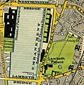
Map of 1897, showing Lambeth Palace and Lambeth Bridge

See also
 In Spanish: Lambeth para niños
