
List of Shetland islands facts for kids

30Jan1973.jpg)
The Shetland Islands are a group of islands in Scotland. They are about 100 kilometers (62 miles) north of mainland Scotland. The capital city, Lerwick, is almost the same distance from Bergen in Norway as it is from Aberdeen in Scotland. There are about 300 islands and small rocky islets called "skerries" in Shetland. Only 16 of these islands have people living on them. The biggest island is called Shetland Mainland. Other large islands are Unst, Yell, and Fetlar.
An island, for this list, is land surrounded by seawater every day. This means even if a bridge connects it, it's still an island if the sea goes all around it. Four islands are connected to the Shetland Mainland by bridges: East Burra, West Burra, Trondra, and Muckle Roe. There is also a bridge from Housay to Bruray. No place in Shetland is more than 5 kilometers (3 miles) from the sea! There's a very narrow strip of land called Mavis Grind. It's only about 100 meters (328 feet) wide. It separates the Atlantic Ocean in the west from the North Sea in the east.
The rocks and land of Shetland are very interesting and complex. These islands are the northern part of an ancient mountain-building event called the Caledonian orogeny. You can find very old rocks here, similar to those on the Scottish mainland. There are also deposits of old red sandstone and granite. A special feature is the "ophiolite" rock on Unst and Fetlar. This rock is a piece of the ancient Iapetus Ocean floor! A lot of Shetland's money comes from the oil found in the seas around the islands. Long ago, around 6200 BC, a huge tsunami (a giant wave) up to 20 meters (66 feet) high hit the islands. This was caused by a massive underwater landslide off the coast of Norway called the Storegga Slides.
The Shetland Islands Council manages all the islands. People have lived here since the Neolithic (New Stone Age) times. For many centuries, the islands were ruled by the Norsemen (Vikings). The first written stories about Shetland come from Norse sagas. Digs at Jarlshof on the Mainland show that people lived in Shetland since the Bronze Age. The yearly Up Helly Aa fire festivals are a fun way to remember Shetland's Viking past. The islands face strong winds and tides. Many lighthouses help ships navigate safely. A small wind farm in Shetland once set a world record for how much power it produced in a year! The small, strong Shetland ponies are famous for being tough and hardy.
Contents
Main Islands of Shetland


The Scalloway Islands are a small group of islands in the southwest. The North Isles include Yell, Unst, and Fetlar. There are also many islands in Yell Sound and St. Magnus Bay. It's hard to group all the Shetland islands because they are so spread out!
We don't know exactly when people stopped living on some of the smaller islands. But most islands on this list probably had people living on them at some point. This could have been during the Stone Age, the time of the Picts, the Viking Age, or more recently.
You'll often see "Ward" in the name of the highest point on an island. This name comes from old times when these high spots were used to light warning fires.
In 2001, about 21,988 people lived in Shetland. By 2011, this number had grown to 23,167.
| Island | Location | Area (ha) | Population | Last inhabited | Highest point | Height (m) |
|---|---|---|---|---|---|---|
| Balta | North Isles | 80 | 0 | Norse times or later | Muckle Head | 44 |
| Bigga | Yell Sound | 78 | 0 | 1930s | 34 | |
| Bressay | East of Lerwick | 2805 | 368 | Ward of Bressay | 226 | |
| Brother Isle | Yell Sound | 40 | 0 | 1820s? | 25 | |
| Bruray | Out Skerries | 55 | 24 | Bruray Ward | 53 | |
| East Burra | Scalloway Islands | 515 | 76 | Easter Heog | 81 | |
| Fair Isle | Outlier | 768 | 68 | Ward Hill | 217 | |
| Fetlar | North Isles | 4078 | 61 | Ward Hill | 158 | |
| Foula | Outlier | 1265 | 38 | The Sneug | 418 | |
| Hascosay | Colgrave Sound, Yell | 275 | 0 | 1850s | 30 | |
| Hildasay | Scalloway Islands | 108 | 0 | 1890s | 32 | |
| Housay | Out Skerries | 163 | 50 | North Hill | 53 | |
| Lamba | Yell Sound | 43 | 0 | unknown | 35 | |
| Linga near Muckle Roe | Swarbacks Minn | 70 | 0 | unknown | 69 | |
| Linga | Bluemull Sound, Yell | 45 | 0 | unknown | 26 | |
| Mainland | Mainland | 96879 | 18765 | Ronas Hill | 450 | |
| Mousa | East of Mainland | 180 | 0 | 1841–60 | Mid Field | 55 |
| Muckle Roe | Swarbacks Minn | 1773 | 130 | Mid Ward | 172 | |
| Isle of Noss | Bressay | 343 | 0 | 1930s | Noup of Noss | 181 |
| Oxna | Scalloway Islands | 68 | 0 | 1901–1930 | Muckle Ward | 38 |
| Papa | Scalloway Islands | 59 | 0 | 1891–1930 | 32 | |
| Papa Little | Swarbacks Minn | 226 | 0 | 1840s | North Ward | 82 |
| Papa Stour | St Magnus Bay | 828 | 15 | Virda Field | 87 | |
| Samphrey | Yell Sound | 66 | 0 | 1841–1880 | 29 | |
| South Havra | Scalloway Islands | 59 | 0 | 1923 | 42 | |
| Trondra | Scalloway Islands | 275 | 135 | 60 | ||
| Unst | North Isles | 12068 | 632 | Saxa Vord | 284 | |
| Uyea, Northmavine | North Mainland | 45 | 0 | unknown | 70 | |
| Uyea, Unst | North Isles | 205 | 0 | 1931–60 | The Ward | 50 |
| Vaila | Gruting Voe | 327 | 2 | East Ward | 95 | |
| Vementry | Swarbacks Minn | 370 | 0 | 1840s | Muckle Ward | 90 |
| West Burra | Scalloway Islands | 743 | 776 | Hill of Sandwick | 65 | |
| West Linga | Whalsay | 125 | 0 | late 18th century | 52 | |
| Whalsay | Whalsay | 1970 | 1061 | Ward of Clett | 119 | |
| Yell | North Isles | 21211 | 966 | Hill of Arisdale | 210 |
Smaller Islets and Skerries


Besides the main islands, Shetland has many smaller islets and skerries. Islets are small islands. Skerries are rocky areas that are only visible when the tide is low. Many of these small places have names like "Holm," which comes from an old Norse word for a "small, round islet." "Swarta Skerry" means "black skerry." "Linga" means "heather island," and "Taing" means "tongue" (like a tongue of land). "Flaesh" means "flat skerry." You might also hear "Hog" and "Calf" for small islands, especially if they are next to a bigger one.
Tidal Islands

St Ninian's Isle is connected to Mainland Shetland by a special sand and shingle bar called a tombolo. This is the biggest active tombolo in the United Kingdom. Even though St Ninian's Isle is quite large, it's not always surrounded by water. It only becomes a true island during very high tides or storms.
Gluss Isle is another example. It's a peninsula connected to the mainland by a tombolo. So, it's not really an island all the time.
Huney also has a tombolo. This can connect it to Unst when the tide is very low.
Images for kids
-
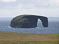
Dore Holm
-
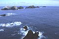
Baa Skerries, Unst
-
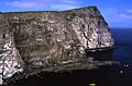
Noup of Noss
-
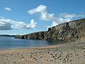
Muckle Ayre, Muckle Roe, looking across Swarbacks Minn
-
Moo Stack, Eshaness, Northmaven
-
Muckle Flaes and Vaila from the east
-
Out Stack, off Unst, the most northerly point in Scotland
-

The skerries north of Unst including Vesta Skerry, Rumblings, Tipta Skerry, Muckle Flugga and Out Stack
-
Galti Stacks off Papa Stour with Fogla Skerry in the background.


See also
 In Spanish: Anexo:Islas del archipiélago de las Shetlands para niños
- Geography of Shetland
- Geology of Scotland
- List of islands called Linga
- List of islands of Scotland
- List of Orkney islands
- List of Outer Hebrides
- North Sea islands
- Shetland population
