
Lycia facts for kids
Quick facts for kids LyciaLukka Likya 𐊗𐊕𐊐𐊎𐊆𐊖 (Trm̃mis) Λυκία (Lykia) |
|
|---|---|
| Ancient Region of Anatolia | |
.jpg)
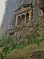
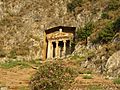
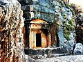
Lycian rock cut tombs of Dalyan
|
|
| Location | Teke Peninsula, Western Taurus Range, Southern Anatolia, Turkey |
| Languages | Lycian, Greek |
| Successive capitals | Xanthos (Kınık) Patara (Gelemiş) |
| Achaemenid satrapy | Cilicia & Lydia |
| Roman protectorate | Lycian League |
| Roman province | Lycia, then Lycia with other states |
| Byzantine eparchy | Lykia |

Location of Lycia. Anatolia/Asia Minor in the Greco-Roman period. The classical regions, including Lycia, and their main settlements
|
|

Lycia was an ancient region in Anatolia, which is now part of Turkey. It existed from around the 15th to 14th centuries BC. This area was known as Lukka in old records. Lycia was located along the Mediterranean Sea, mostly in what are now the Antalya and Muğla areas of Turkey.
People in Lycia spoke the Lycian language, which was written on stone after the region became part of the Achaemenid Empire (Persian Empire) around 546 BC. The cities of Lycia were very rich. You can still see this in their amazing buildings, which date from the 5th century BC all the way to the Roman times.
Lycia fought alongside the Persians in the Persian Wars. But after the Greeks defeated the Persian Empire, Lycia became independent for a while. It joined the Athenian Empire briefly, then became independent again. Later, it was conquered by Mausolus of Caria and then by Alexander the Great.
Under Alexander's rule, Lycia quickly became more like Greece. The Lycian language slowly disappeared from writings and coins. The Roman Republic later gave Lycia to Rhodes for 20 years, but took it back in 168 BC. After that, Lycia enjoyed freedom as a Roman protectorate. The Romans even allowed the Lycian League to govern itself. This local government was an early type of federation, like a group of states working together. Its ideas even influenced the people who wrote the United States Constitution.
However, Lycia was not a fully independent country. In 43 AD, the Roman emperor Claudius made Lycia a Roman province. It later became part of the Eastern Roman, or Byzantine Empire. Even after Turkish speakers arrived, people in Lycia continued to speak Greek. After the Byzantine Empire fell in the 15th century, Lycia became part of the Ottoman Empire. Today, it is part of the Turkish Republic.
Contents
Geography of Lycia

The borders of Lycia changed over time. But its main area was the Teke peninsula in southwestern Turkey. This peninsula sticks out into the Mediterranean Sea. To its west is the Gulf of Fethiye, and to its east is the Gulf of Antalya. Lycia included parts of what are now the Antalya, Muğla, and Burdur provinces. In ancient times, its neighbors were Caria, Pisidia, and Pamphylia. Each of these regions also had its own ancient language.
The Teke Peninsula is named after a Turkish tribe that settled there long ago.
Mountains and Rivers
Lycia has four main mountain ridges that run from northeast to southwest. These are part of the western Taurus Mountains. The westernmost range is the Boncuk Mountains, which are about 2,340 meters (7,677 feet) high. To the west of these mountains, the deep Dalaman Çayi (ancient Indus River) formed the border between Caria and Lycia. This river is 229 kilometers (142 miles) long and flows into the Mediterranean Sea.

East of the Boncuk Mountains are the Akdağlari, or 'White Mountains'. They are about 150 kilometers (93 miles) long and reach 3,024 meters (9,921 feet) at Uyluktepe. The Xanthos River (Eşen Çayi) flows along the western side of these mountains. It runs south and reaches the beach at Patara. The Xanthos Valley was known as Tŗmmis in ancient Lycia.
Further east are the Beydağlari, or 'Bey Mountains'. Their highest point is Kizlarsevrisi, at 3,086 meters (10,125 feet). This is the highest peak on the Teke Peninsula. Between the Beydağlari and Akdağlari is a high plateau called Elmali. The town of Elmali, meaning 'Apple Town', is 1,100 meters (3,609 feet) high.
The Akçay, or 'White River', used to bring water to the plain, forming two lakes. Today, these lakes are dry because the water is used for irrigation. Efforts are being made to regrow some of the cedar forests that were cut down long ago.
The easternmost mountain range is the Tahtali Dağlari. Its highest point is Tahtali Dağ, at 2,366 meters (7,762 feet). The Greeks called this "Mount Olympus." This area has a rugged coastline. Part of it is now a national park called Olimpos Beydağlari Parki. Inside the park, on Mount Olympus, is a place called Yanartaş. Here, natural methane gas escapes from the rocks and feeds eternal flames. This is the site of ancient Mount Chimaera.
The Alakir Çay (Alakir River), known as Limyra in ancient times, flows south through a valley. This valley was home to the ancient Solymi people.
Ancient Settlements
There are at least 381 ancient settlements in the Lycia-Pamphylia region, most of them in Lycia. These towns were often built in protected coves along the coast or on mountain slopes. They were hard to reach, which helped protect them in ancient times. The rugged coastline also had well-defended ports, which Lycian pirate fleets sometimes used.
The most important cities of ancient Lycia were Xanthos, Patara, Myra, Pinara, Tlos, and Olympos. Each of these cities had three votes in the Lycian League. Other important cities included Phaselis and Telmessos.
Features and Sights of Interest


Many ancient Lycian structures can still be seen today. These include unique rock-cut tombs carved into the sides of cliffs. The British Museum in London has a large collection of Lycian artifacts. Letoon, an important ancient Greek worship center for the goddess Leto and her children, Apollo and Artemis, is a UNESCO World Heritage Site. Nearby Xanthos, the ancient capital of Lycia, is also part of this site.
Turkey's first long-distance walking path, the Lycian Way, follows part of the region's coast. This path helps support tourism in small mountain villages. The Turkish Culture and Tourism Ministry promotes the Lycian coast as part of the Turkish Riviera, also known as the Turquoise Coast. This coast has rocky or sandy beaches at the base of cliffs and towns in protected coves that are popular for yachting.
-
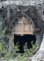
Telmessos rock tomb. The sign on site says the tombs date from about 400 BC
-
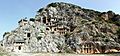
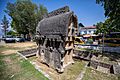
Rock-cut tombs in Myra
-
Ogival rock-cut tomb at Pinara, 4th century BC
-
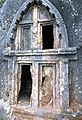
Ancient Lycian tomb in Kaş
-
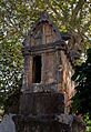
The Tomb of Amyntas in Fethiye
-
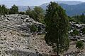
Ancient Greek theater at Oinoanda
-
Lycian tomb in Kaş
-
Lycian tomb in Fethiye
-
Lycian tomb in Kastellorizo


Ancient Language of Lycia


The people of Lycia spoke Lycian, a language related to Luwian and part of the larger Indo-European family. We have records of Lycian from about 500 BC to 300 BC. It was written using a special alphabet based on the Greek alphabet. The Luwian languages first appeared in Anatolia around 2000 BC. At that time, Lycia was known as Lukka and was sometimes ruled by the Hittite Empire.
Around 535 BC, the Achaemenid Empire (Persian Empire) took over Lycia. Even though the people of Xanthos fought hard, Lycia became part of the Persian Empire. The first coins with Lycian writing appeared before 500 BC. Lycia thrived under a monarchy set up by the Persians. Lycians carved many inscriptions on stone for memorials and historical records. We are still learning to understand all of them.

After the Persians were defeated by the Greeks, more Greeks settled in Lycia. Over time, fewer inscriptions were made in Lycian, and more were made in Greek. The Lycian language completely disappeared around the 4th century BC, after Alexander the Great took control. No Lycian inscriptions have been found from after 300 BC.
Later, the Roman Republic ruled Lycia, but allowed the Lycians to govern themselves using Greek as their language. Lycia remained a vassal state under the Roman Empire until it became part of the Byzantine Empire in the 4th century AD. After the Byzantines fell in the 15th century, Lycia came under the Ottoman Empire. Turkish people began to settle there alongside the Greek-speaking communities.
In 1923, after World War I, the Turkish Republic was formed. Greek-speaking communities in Anatolia, including Lycia, were moved to Greece. This was part of a population exchange between Greece and Turkey. Many abandoned Greek villages still stand in Lycia today, like the ghost town of Kayaköy.
History of Lycia
Bronze Age Lukka Lands
During the Late Bronze Age, Lycia was part of the Lukka lands. We know about these lands from ancient records of the Hittite Empire and ancient Egypt. The names Lukka and Lycia are thought to be related.
The Lukka lands were not a single kingdom. Instead, they were made up of many smaller, independent groups. There isn't much archaeological evidence left from the Lukka people. Hittite and Egyptian records describe them as raiders, rebels, and pirates. The Lukka people fought against the Hittites in some wars and later fought for them in the Battle of Kadesh. They are also listed among the groups known as the Sea People.
Persian Rule and Lycian Kings


Around 540 BC, Cyrus the Great, the founder of the Achaemenid Empire (Persian Empire), wanted to conquer all of Anatolia. He sent his general, Harpagus, to do this. Harpagus conquered many states peacefully, but the people of Xanthos in Lycia fought bravely. They were greatly outnumbered. When they were forced back into their city, they gathered their families and belongings, burned them, and then fought to the last man against the Persians.

Archaeological evidence shows a big fire on the Xanthos acropolis in the mid-6th century BC. After this, the Persians allowed Lycia to be ruled by local kings, called "dynasts." These kings were mostly Lycian, but some were Persian. They ruled from a palace in Xanthos. The Persians used these kings to carry out their policies.
The first known Lycian king from coin records was Kuprlli, who ruled from about 480–440 BC. Later kings included Kheriga and Kherei. The last known Lycian king was Perikles, who ruled eastern Lycia from Limyra around 380–360 BC. He rebelled against the Persians but was defeated.
After Perikles, Persian rule became stronger in Lycia. Control was taken by Mausolus, the satrap (governor) of nearby Caria. Lycia remained under Persian control until Alexander the Great conquered it in 334–333 BC.
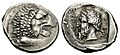
- Portraits on Coins
In ancient times, many coins showed images of gods. But the first coins to show actual rulers' portraits appeared in Lycia in the late 5th century BC. Before this, Persian coins showed a general image of their king, but not a real portrait. After Alexander the Great, it became common for rulers to put their own portraits on coins.
-
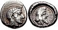
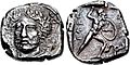
Coin of the Lycian ruler Kherei, showing Athena on one side and himself wearing a Persian cap on the other. 410–390 BC.
-
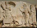
Ruler Arbinas, in Persian clothing, meeting visitors. From the Nereid Monument, around 380 BC.
-
Portrait of Lycian ruler Mithrapata (ruled 390–370 BC).
-
Coin of Perikles, the last king of Lycia. Around 380–360 BC.
-
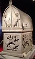
"Lycian sarcophagus of Sidon", from Sidon, late 5th century BC.


.jpg)


Hellenistic Period (333–168 BC)


After Alexander the Great died in 323 BC, his generals fought over his empire. Lycia first came under the control of General Antigonus by 304 BC. Then, it became part of the kingdom of Lysimachus.
Later, Lycia was controlled by the Ptolemaic Kingdom, based in Egypt. Ptolemy II Philadelphos (ruled 285–246 BC) helped the people of Limyra in Lycia when they were threatened by the Galatians (a Celtic tribe). In thanks, the citizens of Limyra built a monument to Ptolemy, called the Ptolemaion, around 270 BC. By 240 BC, Lycia was firmly part of the Ptolemaic Kingdom.
Around 190 BC, Lycia came under Seleucid control. But after the Seleucids were defeated in the Battle of Magnesia, Lycia was given to Rhodes in 188 BC.
The Lycian League
| City | Votes |
|---|---|
| Xanthos | 3 |
| Patara | 3 |
| Myra | 3 |
| Pinara | 3 |
| Tlos | 3 |
| Olympos | 3 |
| Sympolity of Aperlae, Simena, Isinda, Apollonia |
1 |
| Amelas | ? |
| Antiphellus | ? |
| Arycanda | ? |
| Balbura | ? |
| Bubon | ? |
| Cyaneae | ? |
| Dias | ? |
| Gagae | ? |
| Idebessos | ? |
| Limyra | ? |
| Oenoanda | ? |
| Phaselis | ? |
| Phellus | ? |
| Podalia | ? |
| Rhodiapolis | ? |
| Sidyma | ? |
| Telmessus | ? |
| Trebenna | ? |
The Lycian League was a group of independent city-states. It was one of the first democratic unions in history. The League stayed strong despite its mountainous land, invasions, and attempts by rulers to take power.
The Lycian League is first mentioned in records from the early 2nd century BC. It might have been formed to convince Rome to free Lycia from Rhodian control. In 190 BC, Rome had put Lycia under the control of Rhodes. But the Lycians complained to Rome that the Rhodians were treating them badly. They said they were like slaves.
The Roman Senate agreed with the Lycians. In 169 BC, Rome decided that the Lycians should be free. The Lycian League then had the right to govern itself.
The League had 23 cities. The largest cities, like Xanthos and Patara, had three votes in the general assembly. Medium-sized cities had two votes, and smaller ones had one. The League could choose its own leader, called a Lyciarch, and hold courts. However, they could not decide on war and peace without Rome's permission. Because they had such a good government, they remained free under Roman rule for a long time.
Roman Period
Lycia became a protectorate of Rome in 168 BC, meaning Rome protected it but allowed it to govern itself. This lasted until 43 AD, when Emperor Claudius made Lycia a Roman province.
When Rome became involved in the eastern Mediterranean, the Lycians became allies with Rome. An ancient inscription shows that they had a peace and alliance treaty. This treaty said that both sides would help each other if attacked. It also said that Romans accused of serious crimes in Lycia would be judged in Rome, and Lycians accused of serious crimes would be judged in Lycia.


In 43 AD, Emperor Claudius officially took over Lycia. Some historians say this was because the Lycians had revolted and killed some Romans. Others say it was because of serious internal conflicts among the Lycians. An inscription from Perge says that the Lycians thanked Claudius for bringing back peace and order. Rome brought stability to Lycia and allowed the Lycian League to keep its self-governance for local matters.
In 74 AD, Emperor Vespasian combined the Roman provinces of Lycia and Pamphylia into one larger province called Lycia et Pamphylia.

Byzantine and Turkish Eras
During the Byzantine period, Lycia was part of a naval district called the Karabisianoi. Later, it became part of the Theme of the Cibyrrhaeots, another administrative region.
Lycia was eventually taken over by the Ottoman Empire and became part of modern-day Turkey. After World War I, Lycia was briefly given to Italy, but in 1923, it officially became part of Turkey.
For centuries, both Turkish and Greek communities lived in Lycia. However, after the Greco-Turkish War (1919–1922), the large Christian Greek community was forced to move to Greece in a population exchange. Many abandoned Greek villages, like the ghost town of Kayaköy, are still visible today. A small number of Turkish farmers moved into the region after the Greeks left. Today, Lycia is a very popular place for both local and international tourism in Turkey.
In Greek Mythology

According to the ancient historian Herodotus, the earliest name for the area was Milyas. Its first people were the Milyae, also known as the Solymi.
In Greek mythology, Solymus was the hero who gave his name to the Solymi people. He was said to be a son of Zeus or Ares. Later, Sarpedon and his people, the Termilae, settled in Milyas after being driven out of Crete. Then, Lycus of Athens also settled there. The region was later named Lycia in honor of Lycus.
Lycia also appears in the story of Bellerophon, a hero who eventually became king of Lycia. The famous poet Homer often mentioned Lycia in his epic poem, the Iliad. In the Iliad, the Lycian army was led by two brave warriors: Sarpedon (son of Zeus) and Glaucus.
See also
- Ancient regions of Anatolia
- Lycian peasants
- Lycian script
- Saint Gerasimus of the Jordan, 5th-century Christian saint born in Lycia
- Saint Nicholas, Christian saint said to have been born in Patara, Lycia
- Saint Christopher, Christian saint said to have been of the region of Lycia
