Middlesex County, Virginia facts for kids
Quick facts for kids
Middlesex County
|
||
|---|---|---|

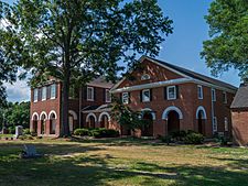
Middlesex County Courthouse in Saluda
|
||
|
||

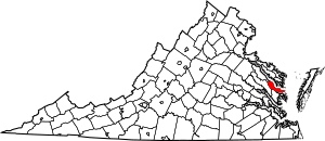
Location within the U.S. state of Virginia
|
||
 Virginia's location within the U.S. |
||
| Country | ||
| State | ||
| Founded | 1668 | |
| Named for | Middlesex, England | |
| Seat | Saluda | |
| Largest town | Urbanna | |
| Area | ||
| • Total | 211 sq mi (550 km2) | |
| • Land | 130 sq mi (300 km2) | |
| • Water | 80 sq mi (200 km2) 38.2% | |
| Population
(2020)
|
||
| • Total | 10,625 | |
| • Density | 50.36/sq mi (19.44/km2) | |
| Time zone | UTC−5 (Eastern) | |
| • Summer (DST) | UTC−4 (EDT) | |
| Congressional district | 1st | |
Middlesex County is a county located in the state of Virginia, USA. It's found on a piece of land called the Middle Peninsula. In 2020, about 10,625 people lived here. The main town where the county government is located is Saluda.
Contents
History of Middlesex County
Long ago, this area was home to Native American tribes. They spoke the Algonquian language and were part of a group called the Powhatan Confederacy. One tribe, the Nimcock, had a village where the town of Urbanna is today.
English settlers started arriving around 1640. Middlesex County was officially created in 1668. It was formed from a part of Lancaster County. The arrival of English settlers caused the Nimcock people to move further up the river.
The only official town in the county, Urbanna, was started in 1680. It was one of 20 port towns chosen by the colonial government for trade. Urbanna became an important port on the Rappahannock River. Farmers used it to ship their crops, especially tobacco. Tobacco was a very important crop back then. As the county grew, Urbanna became its main business and government center.
Rosegill Estate and Plantations
The Rosegill Estate was a large farm, called a plantation. It was started in 1649 by Ralph Wormeley. Many buildings were built there during the 1600s. Rosegill even served as the temporary capital of the Virginia colony for a short time. Two royal governors stayed there.
Like other plantations in the county, Rosegill grew a lot of tobacco. Growing tobacco needed many workers. Enslaved African Americans were forced to do this hard work through the 1700s.
In the 1800s, some plantation owners in Virginia started growing different crops. These crops needed fewer workers. So, many enslaved people were sold to plantations in the southern states. Other plantation owners moved south themselves, taking enslaved people with them. For example, Thomas Wingfield moved to Georgia in 1783 with 23 enslaved people.
After the American Civil War, enslaved people became free. Many freedmen stayed in Middlesex County. They worked on farms for pay or a share of the crops. Others moved to towns to find different jobs.
Today, the Rosegill mansion is still a private home. In recent years, a company bought most of the land. They plan to build many new homes there. During surveys of the land, archaeologists found interesting things. They found what seems to be parts of the old Nimcock village. They also found signs of the community where enslaved African Americans lived at Rosegill.
The American Civil War and Urbanna
During the American Civil War, Urbanna was almost a key landing spot for Union General George B. McClellan. He planned to land his troops there in 1862. His goal was to march to Richmond, the capital of the Confederacy. However, McClellan changed his plan. He decided to start from Fort Monroe instead. This made his journey to Richmond much longer. The delay gave the Confederate army more time to build strong defenses. This was one reason why the Union army failed in this campaign.
Middlesex County Courthouses
The historic Middlesex County Courthouse was built between 1850 and 1874. It is a very important building and is listed on the National Register of Historic Places.
A new county courthouse was built in 2003-2004. However, it wasn't used until 2007 because of a legal disagreement. The old historic courthouse has been updated. It is now used for county meetings and the Registrar's Office.
Urbanna became an official town on April 2, 1902. It is still the county's largest business center and its only official town. The county government's main office moved to the village of Saluda. Saluda is located on U.S. Route 17.
To the east, near Stingray Point, is the village of Deltaville. It is on State Route 33. Deltaville was once famous for building wooden boats. Now, it is known for its businesses and fun activities. Its waterfront has many marinas, especially around Broad Creek.
Geography of Middlesex County
Middlesex County is located at the eastern end of Virginia's Middle Peninsula region. The county covers a total area of about 211 square miles (546 square kilometers). About 130 square miles (337 square kilometers) is land, and 80 square miles (207 square kilometers) is water. This means a large part of the county is water, about 38.2%.
The Rappahannock River forms the northern border of the county. The Chesapeake Bay is to the east. The Piankatank River and Dragon Run Swamp are to the southwest. Essex County is to the northwest. The county has about 135 miles (217 kilometers) of shoreline.
Adjacent counties
- Lancaster County – North
- Mathews County – South
- Gloucester County – Southwest
- King and Queen County – West
- Essex County – Northwest
Population of Middlesex County
| Historical population | |||
|---|---|---|---|
| Census | Pop. | %± | |
| 1790 | 4,140 | — | |
| 1800 | 4,203 | 1.5% | |
| 1810 | 4,414 | 5.0% | |
| 1820 | 4,057 | −8.1% | |
| 1830 | 4,122 | 1.6% | |
| 1840 | 4,392 | 6.6% | |
| 1850 | 4,394 | 0.0% | |
| 1860 | 4,364 | −0.7% | |
| 1870 | 4,981 | 14.1% | |
| 1880 | 6,252 | 25.5% | |
| 1890 | 7,458 | 19.3% | |
| 1900 | 8,220 | 10.2% | |
| 1910 | 8,852 | 7.7% | |
| 1920 | 8,157 | −7.9% | |
| 1930 | 7,273 | −10.8% | |
| 1940 | 6,673 | −8.2% | |
| 1950 | 6,715 | 0.6% | |
| 1960 | 6,319 | −5.9% | |
| 1970 | 6,295 | −0.4% | |
| 1980 | 7,719 | 22.6% | |
| 1990 | 8,653 | 12.1% | |
| 2000 | 9,932 | 14.8% | |
| 2010 | 10,959 | 10.3% | |
| 2020 | 10,625 | −3.0% | |
| U.S. Decennial Census 1790–1960 1900–1990 1990–2000 2010 2020 |
|||
Population in 2020
The table below shows the different groups of people living in Middlesex County. It shows how the population changed between 2010 and 2020. The US Census counts people by race and also by whether they are Hispanic or Latino. People who are Hispanic or Latino can be of any race.
| Race / Ethnicity (NH = Non-Hispanic) | Pop 2010 | Pop 2020 | % 2010 | % 2020 |
|---|---|---|---|---|
| White alone (NH) | 8,604 | 8,339 | 78.51% | 78.48% |
| Black or African American alone (NH) | 1,956 | 1,519 | 17.85% | 14.30% |
| Native American or Alaska Native alone (NH) | 35 | 24 | 0.32% | 0.23% |
| Asian alone (NH) | 37 | 26 | 0.34% | 0.24% |
| Pacific Islander alone (NH) | 1 | 3 | 0.01% | 0.03% |
| Some Other Race alone (NH) | 5 | 40 | 0.05% | 0.38% |
| Mixed Race or Multi-Racial (NH) | 155 | 415 | 1.41% | 3.91% |
| Hispanic or Latino (any race) | 166 | 259 | 1.51% | 2.44% |
| Total | 10,959 | 10,625 | 100.00% | 100.00% |
Ethnic Backgrounds
In 2016, the largest groups of people in Middlesex County, based on their family's background, were:
- English - 29.9%
- Irish - 14.1%
- German - 11.5%
- American - 10.8%
- French - 3.7%
Education in Middlesex County
Middlesex County Public Schools (MCPS) is the public school system for the county. Here are the schools in the system:
- Middlesex Elementary (Grades Pre-Kindergarten - 5th)
- St. Clare Walker Middle (Grades 6th - 8th)
- Middlesex High School (Grades 9th - 12th)
Another school in Middlesex County is:
- Christchurch School (Grades 9th - 12th, a private school for both boys and girls)
Communities in Middlesex County
Town
Census-designated places
These are areas that are like towns but are not officially incorporated.
Other unincorporated communities
These are smaller communities that are not officially towns or census-designated places.
- Butylo
- Christchurch
- Church View
- Hardyville
- Hartfield
- Jamaica
- Locust Hill
- Nohead Bottom
- Remlik
- Stingray Point
- Syringa
- Topping
- Wake
- Water View
See also
 In Spanish: Condado de Middlesex (Virginia) para niños
 | Misty Copeland |
 | Raven Wilkinson |
 | Debra Austin |
 | Aesha Ash |


