Milan, New York facts for kids
Quick facts for kids
Milan, New York
|
|
|---|---|
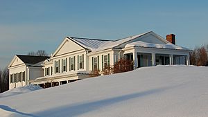
Wilcox Memorial Town Hall, Route 199, Milan
|
|
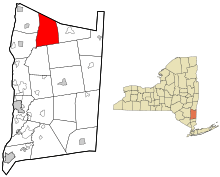
Left: Map of Dutchess County, New York with Milan highlighted.
Right: Map of New York State with Dutchess County highlighted. |
|
| Country | United States |
| State | New York |
| County | Dutchess |
| Government | |
| • Type | Town Council |
| Area | |
| • Total | 36.58 sq mi (94.73 km2) |
| • Land | 36.11 sq mi (93.52 km2) |
| • Water | 0.47 sq mi (1.21 km2) |
| Elevation | 551 ft (168 m) |
| Population
(2020)
|
|
| • Total | 2,245 |
| Time zone | UTC-5 (Eastern (EST)) |
| • Summer (DST) | UTC-4 (EDT) |
| ZIP codes |
Four post offices:
|
| Area code(s) | 845 |
| FIPS code | 36-027-47207 |
| GNIS feature ID | 0979218 |
Milan (pronounced MY-lin) is a small town in Dutchess County, New York. It is located in the northern part of the county and is mostly rural, meaning it has lots of open land and farms.
In 2020, about 2,245 people lived in Milan. This was a small decrease from 2,370 people in 2010. Milan is about 90 miles (145 km) north of New York City and 60 miles (97 km) south of Albany. It is also about 150 miles (241 km) west of Boston.
The town is surrounded by other towns. To the west are Rhinebeck and Red Hook. To the east is Pine Plains. Stanford is to the southeast, and Clinton is to the south. To the north, Milan borders Gallatin in Columbia County. The main road that goes through Milan is NY 199. The historic Taconic State Parkway also runs through the town.
Contents
Milan's History: From Farms to Today
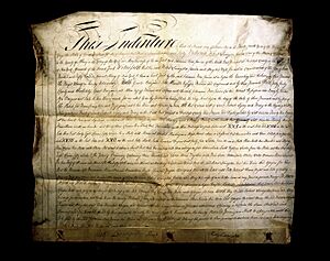
The area where Milan is today was once the western part of a large land grant called the Little Nine Partners Patent from 1706. For a long time, Milan was mainly a town for farming and mills. It still has a very rural feel today.
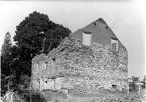
The first person to settle here was Johannes Rowe. His father was an immigrant from a region in Germany called Palatine. In 1760, Johannes Rowe bought 911 acres (3.69 km2) of land from Robert Livingston. In 1766, he built a stone house on what is now Rowe Road, close to the Milan Town Hall. Pictures of the house's remains were taken in 1940 for a historical survey.
How Milan Became a Town
On March 6, 1818, the New York State Legislature decided to create the town of Milan. It was formed from the western part of the town of North East. This change officially happened at the end of March 1818. The first town meeting was held in April at the home of Stephen Thorn, who became the first town supervisor. John F. Bartlett was elected as the first town clerk.
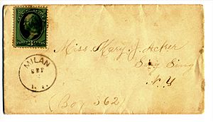
Historians from the 1800s don't know why the name "Milan" was chosen. However, it was common at that time to name new towns after European cities. For example, what is now Syracuse was briefly called "Milan" between 1809 and 1812. Another settlement south of Syracuse was also called "Milan" before it became the town of Locke in 1802. The post office there changed its name to "Locke" in 1817. This made it possible for Milan, New York, to open its own post office on August 14, 1818, at a place now called Case's Corners.
Milan's Role as a "Town In-Between"
The main roads in Milan used to connect the Hudson River to Salisbury, Connecticut. Travelers called this road the "turnpike." It later became known as the Salisbury Turnpike. Parts of this old road still exist today and keep that name.
Besides farming and local mills, areas around Milan also had mines for lead and iron. These materials were taken to furnaces in Ancram. Milan was located "in-between" these mining towns and the river. This meant a lot of important trade traffic passed through Milan, moving goods from east to west.
Population Changes Over Time
Milan's population first reached its highest point in 1840 with 1,745 residents. After that, the population started to go down until 1930, when only 622 people lived there. This decline happened because of the opening of the Erie Canal in 1825 and the growth of railroads. People also started moving to cities along the river or heading west. Also, Milan's land was hilly and rocky, which made farming difficult.
After the 1930s and the Great Depression, the population started to grow again. This was partly because the Taconic Parkway was built, which ended in Milan at the time. The population also grew after World War II.
The population level of 1840 was finally reached again in 1980, 140 years later. From the 1980s to the early 2000s, Milan was one of the fastest-growing towns in Dutchess County. However, it is still the town with the fewest people in the county.
Historic Markers in Milan
You can find several historic markers in Milan that tell about its past:
- Jackson Corners—Colonial Inn: This building was built around 1773. It was a stagecoach stop, a doctor's office, a hotel, a store, and a post office.
- Jackson Corners—Nobletown Road: This road was used before 1798. It ran from Livingston, through Gallatin and Ancram, to Nobletown in New Hampshire.
- Turkey Hill Road—Fulton Homestead: John Fulton was the first owner of this home. Records show he bought it on October 12, 1795. The house stayed in the Fulton family until 1933.
- Turkey Hill Road—Burial Ground: This is where Chief Crow and other Mohican people of the Moravian faith were buried. The last burial here was around 1850.
Geography and Roads in Milan
Milan covers a total area of about 36.58 square miles (94.7 square kilometers). Most of this area, about 36.11 square miles (93.5 square kilometers), is land. The rest, about 0.47 square miles (1.2 square kilometers), is water.
The northern border of Milan is also the border of Columbia County.
The Taconic State Parkway runs from north to south through the eastern part of the town. This entire highway and its structures are listed on the National Register of Historic Places because of their historical importance.
New York State Route 199 goes from east to west through Milan. To the west, it leads to Red Hook and crosses the Kingston–Rhinecliff Bridge. To the east, it is a direct route to Pine Plains and Millerton.
Parks and Outdoor Fun
The New York State Department of Environmental Conservation manages two large outdoor areas in Milan. Both are east of the Taconic State Parkway.
- The Lafayetteville Multiple Use Area is 769 acres (3.11 km2). You can find its entrance on Route 199, between the Taconic State Parkway and New York State Route 82.
- The Roeliff Jansen Kill Multiple Use Area is 125 acres (0.51 km2). You can get to it from a small parking area on the east side of the Taconic State Parkway, near the Roeliff Jansen Kill.
Dutchess County also owns and takes care of the 615-acre (2.49 km2) Wilcox Memorial Park. This park is on Route 199, about 3.4 miles (5.5 km) east of the Taconic State Parkway.
The town of Milan has its own park called the Milan Rec Park, located on South Road. It has a softball field and a play area for children. There's also a trail that the Milaners Youth Group helps maintain. This park is also where the town's recycling and transfer station is located.
Dutchess County Tourism suggests a scenic driving tour that includes Milan, so visitors can enjoy the beautiful views of the town.
Future Plans and Land Use
In 2002, a company called the Durst Organization bought 2,300 acres (9.3 km2) of land that stretches across Milan and Pine Plains. This company is known for building tall buildings in Manhattan. They planned to create a community with second homes and places for recreation. Their first idea included almost 1,000 homes and golf courses. In 2010, they changed their plans to allow for 624 homes, with 52 of them in Milan.
Also in 2002, another company, Red Wing Sand and Gravel, bought two large pieces of land in northern Milan. They wanted to open two big mines there. However, on March 30, 2010, the New York Supreme Court sided with the Town of Milan. The court upheld the town's ban on mining across the entire town. The New York Attorney General's office successfully defended the town, stopping the mining company from building mines in those areas.
Milan's Population Over the Years
| Historical population | |||
|---|---|---|---|
| Census | Pop. | %± | |
| 1820 | 1,797 | — | |
| 1830 | 1,886 | 5.0% | |
| 1840 | 1,725 | −8.5% | |
| 1850 | 1,764 | 2.3% | |
| 1860 | 1,522 | −13.7% | |
| 1870 | 1,474 | −3.2% | |
| 1880 | 1,275 | −13.5% | |
| 1890 | 1,026 | −19.5% | |
| 1900 | 950 | −7.4% | |
| 1910 | 893 | −6.0% | |
| 1920 | 704 | −21.2% | |
| 1930 | 622 | −11.6% | |
| 1940 | 695 | 11.7% | |
| 1950 | 806 | 16.0% | |
| 1960 | 944 | 17.1% | |
| 1970 | 1,322 | 40.0% | |
| 1980 | 1,668 | 26.2% | |
| 1990 | 1,895 | 13.6% | |
| 2000 | 2,356 | 24.3% | |
| 2010 | 2,370 | 0.6% | |
| 2020 | 2,245 | −5.3% | |
| U.S. Decennial Census | |||
In 2010, there were 2,370 people living in Milan. These people lived in 964 households, and 650 of those were families. The population density was about 65.7 people per square mile. There were 1,279 housing units in total.
Most of the people in Milan were white (95.3%). There were also smaller percentages of African American (1.9%), Native American (0.5%), and Asian (0.5%) residents. About 4.4% of the population identified as Hispanic or Latino.
In 2010, about 30.6% of households had children under 18 living with them. Most households (55.0%) were married couples living together. About 24.5% of all households were made up of people living alone. The average household had 2.45 people, and the average family had 2.94 people.
The population's age range was spread out. About 22.0% were under 18, and 14.6% were 65 or older. The average age in Milan was 45.6 years.
From 2009 to 2013, the average yearly income for a household in Milan was estimated to be $65,529. For families, the average income was $77,396. About 3.0% of the population lived below the poverty line.
Places in Milan
Milan has several smaller communities within its borders:
- Jackson Corners – This area is in the northeastern part of town, near the Roeliff Jansen Kill. It had a post office for many years. In 1840, it had one church and 25 houses.
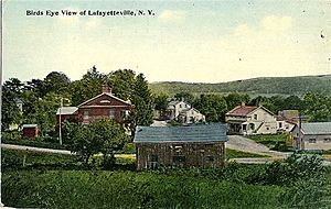
- Lafayetteville – This small village is east of Milan village. It used to be called Lafayetter Corners. It was named after the Marquis de Lafayette, a French hero who visited the area in 1824. It also had a post office for many years.
- Milanville – This was the original location of the Milan post office from 1818 to 1908. It's at the meeting point of Salisbury Turnpike and Milan Hollow Road. Today, it's known as "Case's Corner."
- Rock City – This village is west of Milan village. In 1840, it had a mill for grinding grain and sawing wood, plus 20 houses. It used to be called Travers Mill. A post office operated here from 1835 to 1904.
- Shookville – This was a community in the northwestern part of town, started by Jacob Shook. It had a post office from 1827 to 1835.
Famous People from Milan
- Jane Marsh Parker (1836-1913), an author, historian, and clubwoman.
See also
 In Spanish: Milan (Nueva York) para niños
 | Charles R. Drew |
 | Benjamin Banneker |
 | Jane C. Wright |
 | Roger Arliner Young |


