Mount Fee facts for kids
Quick facts for kids Mount Fee |
|
|---|---|

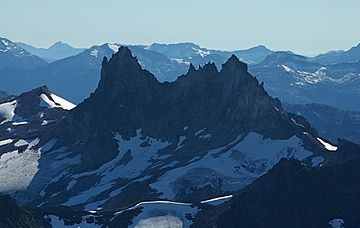
Mount Fee as seen from the northeast
|
|
| Highest point | |
| Elevation | 2,162 m (7,093 ft) |
| Prominence | 312 m (1,024 ft) |
| Geography | |
| Parent range | Pacific Ranges |
| Topo map | NTS 92J/03 |
| Geology | |
| Age of rock | Unknown |
| Mountain type | Eroded volcano |
| Volcanic arc/belt | Canadian Cascade Arc Garibaldi Volcanic Belt |
| Last eruption | Unknown; Pleistocene age |
Mount Fee is a cool volcanic mountain in the Pacific Ranges. These ranges are part of the Coast Mountains in southwestern British Columbia, Canada. It's located about 13 km (8.1 mi) south of Callaghan Lake. It's also about 21 km (13 mi) west of the popular resort town of Whistler.
Mount Fee stands tall at 2,162 m (7,093 ft) high. It rises above the rugged land around it. This mountain is part of a long, narrow ridge. This ridge is a volcanic field that runs north to south.
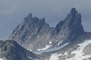
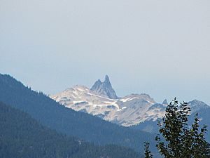
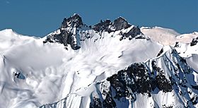
The mountain itself is a narrow ridge. It's made of fine volcanic rock. It's about 1.5 km (0.93 mi) long and 0.5 km (0.31 mi) wide. Its sides are very steep. Mount Fee has two main peaks. The one to the south is the highest. A U-shaped gap separates the two peaks. This gap makes them look very striking.
Contents
How Mount Fee Was Formed
Mount Fee is one of the volcanoes in the Mount Cayley volcanic field. This area is part of the larger Garibaldi Volcanic Belt. This belt stretches from the Silverthrone Caldera in the north. It goes all the way south to the Watts Point volcano.
This volcanic belt formed because of something called subduction. This is when one of Earth's huge plates, the Juan de Fuca Plate, slides under another, the North American Plate. This happens at the Cascadia subduction zone. This zone is a long crack in the Earth. It runs along the British Columbia Coast. The plates move slowly, about 10 mm (0.39 in) each year.
An Ancient Volcano's Remains
Mount Fee is what's left of a volcano that has been greatly worn down. This happened because of glacial ice. It was likely a much bigger volcano once. It was probably a stratovolcano, also called a composite volcano. Stratovolcanoes are cone-shaped. They are made of layers of lava, volcanic ash, and rocks. They can be very tall, sometimes over 2,500 m (8,000 ft).
During the glacial periods, huge sheets of ice moved across the land. These glaciers scraped away much of the volcano's outer layers. This exposed the hard dacite lava inside. This lava now forms the narrow ridge of Mount Fee. The Black Tusk, another famous peak nearby, is also an old, eroded volcano.
Mount Fee's Eruptions
Mount Fee is one of the oldest volcanoes in its area. Scientists don't know its exact age. But the way it's eroded shows it formed over 75,000 years ago. This was before the last major ice age. Because of this, we don't know exactly when its eruptions happened.
Mount Fee has had at least three periods of eruptions. The first eruptions were likely explosive eruptions. Only a small bit of rock from this time is left. The second period created layers of rock on the eastern side of the mountain. This material probably flowed down the volcano's sides as lava and broken rock.
After a lot of erosion, new lava flowed on the northern side. This lava was thick and sticky. It formed the U-shaped gap between the two main peaks. This lava came from a pipe-like opening inside the volcano. This opening went through older rocks. More erosion followed this last eruption. This erosion, likely from more ice ages, shaped Mount Fee into the rugged ridge we see today.
Human History at Mount Fee
People have lived near Mount Fee for thousands of years. They used the glassy volcanic rocks from the mountain. These rocks, like rhyodacite, were great for making tools. People used them for knives, chisels, and other sharp tools. This was before Europeans arrived in the 1700s.
These tools were found at ancient sites. Some were goat hunting sites. Others were at the Elaho rockshelter. These sites date back from about 100 to 8,000 years ago.
Naming and Study
In 1928, a British mountaineer named Tom Fyles named Mount Fee. He named it after Charles Fee. Charles Fee was a member of the British Columbia Mountaineering Club. This club was in Vancouver.
Later, in 1980, a volcanologist named Jack Souther studied Mount Fee. He included it in his illustrations of the Mount Cayley volcanic field. He also made a geologic map in 1981. This map showed where the volcanoes were located.
Watching the Volcano
The Geological Survey of Canada doesn't watch Mount Fee very closely. This is true for other volcanoes in the Garibaldi Belt too. One reason is that Canada hasn't had a major eruption in over a hundred years. Also, Mount Fee is in a remote area.
Because of this, monitoring volcanoes is less urgent. Other natural events like tsunamis, earthquakes, and landslides get more attention. No recent earthquakes have happened at Mount Fee.
If Mount Fee were to erupt, there would likely be warnings. These could be weeks, months, or even years of small earthquakes. These quakes would happen deep underground. They are usually too small for people to feel. There are seismographs (devices that detect quakes) in the area. But they are too far away to give a clear picture of what's happening under the mountain.
A big eruption at Mount Fee would have a huge impact. This is especially true because the Garibaldi Belt is near a highly populated area. Scientists from Canadian universities are working to learn more about these volcanoes. This helps them understand the risks better.
Weather Around Mount Fee
Mount Fee is in a marine west coast climate zone. This means it gets a lot of moisture from the Pacific Ocean. Weather systems move east towards the Cascade Range. The mountains force the air upward. This causes the moisture to fall as rain or snow.
The Cascade Mountains get a lot of rain and snow. This is especially true in winter. Temperatures can drop very low, sometimes below −20 °C. With wind, it can feel even colder. The best time to climb Mount Fee is usually from July to September. The weather is most favorable then.
 | George Robert Carruthers |
 | Patricia Bath |
 | Jan Ernst Matzeliger |
 | Alexander Miles |


