Nanjemoy, Maryland facts for kids
Quick facts for kids
Nanjemoy, Maryland
|
|
|---|---|
| Country | |
| State | |
| County | |
| Time zone | UTC-5 (Eastern (EST)) |
| • Summer (DST) | UTC-4 (EDT) |
| ZIP codes |
20662
|
Nanjemoy is a small community in Charles County, Maryland, in the United States. It's located in the southwestern part of the county, near Maryland Route 6. The area is surrounded by Nanjemoy Creek to the east and north, and the Potomac River to the south and west.
Contents
Exploring Nanjemoy's Location
Nanjemoy is part of the larger Washington, D.C. area. It's about 25 miles (40 km) south of the Capital Beltway, which includes major highways like Interstate 95 and Interstate 495.
Roads and Travel in Nanjemoy
The Nanjemoy area is served by Maryland Route 6 and other two-lane state roads. The closest main roads are Maryland Route 210 to the north and U.S. Route 301 to the east. More and more people who work in the Washington area are choosing to live here. This is especially true for those working in nearby Indian Head, Fort Washington, or Alexandria, Virginia.
Nearby Towns and Features
The shopping areas of Waldorf, Maryland and La Plata, Maryland are close by to the east, along U.S. 301. There are no train lines in the Nanjemoy area. Other small communities nearby include Grayton, Maryland Point, and Riverside. To the north, you'll find Chicamuxen, Doncaster, and Ironsides.
Nanjemoy's Unique Geology
The Nanjemoy area gives its name to the Nanjemoy Formation. This is a special type of rock layer that can be seen along the nearby shores of the Potomac River. Other rock formations with fossils, like the Aquia and Calvert Formations, are also found here.
Life and Work in Nanjemoy
The center of Nanjemoy has a Post Office and a community center run by the county. These serve the people living in the area. There are also two children's camps and a training center for sheriff's deputies. Much of Nanjemoy is covered by forests or farmlands. In the past, tobacco was a common crop grown here, but it's rarely grown now.
A Look Back at Nanjemoy's History
Nanjemoy and its creek get their names from a Native American tribe that once lived here. During the early part of the American Civil War, a large group of Union soldiers camped near Chicamuxen. This area is a few miles north of Nanjemoy. About 12,000 soldiers were stationed there.
The Shipwrecks of Mallows Bay
Towards the end of World War I, German submarines were causing problems for Allied ships. The U.S. military started building many wooden ships. These ships were anchored in Widewater, Virginia, but the war ended before they could be used. Most of these ships were moved across the Potomac River to a quiet bay called Mallows Bay. This bay became a kind of junkyard for ships. Some ships were taken apart, but most of them sank.
By 1970, these sunken ships had become an important part of the local environment. In the 1990s, even older boats from the American Revolutionary War were found here, along with more modern ships. In 2002, Mallows Bay was protected by the state of Maryland. In 2015, it was suggested to become a National Marine Sanctuary.
The sunken hulls of dozens of these old wooden boats can still be seen at low tide in Mallows Bay. This spot in the Nanjemoy area is known as the "largest shipwreck fleet in the Western Hemisphere."
Famous People from Nanjemoy
- Raphael Semmes: He was a captain for the Confederate Navy. He commanded the famous ship CSS Alabama.
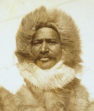
- Matthew Henson: He was an Arctic explorer. He explored the Arctic with Robert Peary in 1909. They may have been the first to reach the North Pole.
Nanjemoy's Natural Wonders
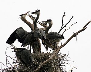
The Nanjemoy area is located on the Atlantic Coastal Plain. It is home to the largest group of great blue herons (Ardea herodias) nesting in the Eastern United States north of Florida. This area is now a special preserve managed by The Nature Conservancy.
Parks and Preserves
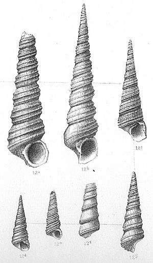
The area also includes Purse State Park. This park is famous for its fossil shark teeth and Turritella snails. These fossils are from the Paleocene geological age. Other protected wild areas are found along the Potomac River's freshwater tidal shore. Nearby parks include Smallwood State Park, the Chicamuxen Wildlife Management Area, the Doncaster Demonstration Forest, and Chapel Point State Park.
Learning at Nanjemoy Creek
The Nanjemoy Creek Environmental Education Center is run by the Charles County Public School system. It's located along Nanjemoy Creek. This center has hiking trails, a boardwalk through a freshwater tidal marsh, and a pier. There's also a laboratory building and cabins for school groups. An observatory there, run by the Southern Maryland Astronomical Society, has a special dome. This dome was once used at a nearby U.S. Naval Research Laboratory facility.
Fun Things to Do in Nanjemoy
Hunting and fishing have always been popular in the Nanjemoy area. It's a mostly undeveloped place with many miles of quiet hiking trails. More recently, the area's beautiful, less-traveled roads have become popular with cyclists.
Boating and Water Activities
Public boat ramps are available on the Potomac at Mallows Bay. Another ramp is on the estuarine part of Nanjemoy Creek at Friendship Landing, which is also popular for fishing. People who enjoy boating, especially from the Woodbridge and Quantico areas across the Potomac, often visit the large undeveloped river shore in the Purse State Park area. Kayaking is also becoming more popular here. You can kayak on the Potomac or on the calm tidewaters of Nanjemoy Creek.
 | Laphonza Butler |
 | Daisy Bates |
 | Elizabeth Piper Ensley |


