
Panama City facts for kids
Quick facts for kids
Panama City
Ciudad de Panamá
|
|||||
|---|---|---|---|---|---|
| Nuestra Señora de la Asunción de Panamá | |||||
|
|
|||||
|
|||||

Panama City
Location in Panama

Panama City
Location in South America

Panama City
Location in North America

Panama City
Location in North Atlantic

Panama City
Location in America

Panama City
Location in Caribbean
|
|||||
| Country | Panama | ||||
| Province | Panamá Province | ||||
| District | Panamá District | ||||
| Foundation | 15 August 1519 | ||||
| Founded by | Pedro Arias de Ávila | ||||
| Area | |||||
| • Capital city | 2,082 km2 (804 sq mi) | ||||
| • Metro | 2,560.8 km2 (988.7 sq mi) | ||||
| Elevation | 2 m (7 ft) | ||||
| Population
(2023)
|
|||||
| • Capital city | 1,086,990 | ||||
| • Density | 522.09/km2 (1,352.2/sq mi) | ||||
| • Urban | 2,100,189 | ||||
| GDP (PPP, constant 2015 values) | |||||
| • Year | 2023 | ||||
| • Total | $65.8 billion | ||||
| • Per capita | $33,300 | ||||
| Area code(s) | (+507) 2, 3 | ||||
| HDI (2017) | 0.820 – very high | ||||
| Website | MuPa.gob.pa | ||||


.jpg)


Panama City, also called Panama (or Panamá in Spanish), is the capital and largest city of Panama. About 1,086,990 people live there, with over 2,100,000 in its wider urban area. The city is located at the Pacific entrance of the famous Panama Canal. It is the main center for government, banking, and business in the country.
The city of Panama was started on August 15, 1519, by a Spanish explorer named Pedro Arias Dávila. It was a key starting point for trips that led to the conquest of the Inca Empire in Peru. It was also an important stop on a major trade route across the American continent. Most of the gold and silver that Spain took from the Americas passed through here.
On January 28, 1671, the first city was burned down by a privateer (a type of pirate) named Henry Morgan. The city was officially rebuilt two years later, on January 21, 1673. This new city was about 8 kilometers (5 miles) from the old one. The ruins of the first city, known as Panamá Viejo, are now a World Heritage Site and a popular place for tourists and school trips to visit.
Contents
History of Panama City


The city was founded on August 15, 1519, by Pedro Arias de Ávila. Soon after, it became a base for exploring and conquering Peru. It was also a place where gold and silver were transported back to Spain. In the 1520s, merchants from Genoa (Italy) controlled the port's trade, especially the slave trade.
In 1671, the pirate Henry Morgan and his 1,400 men attacked and robbed the city. It was then destroyed by fire. The ruins of this old city are still a popular tourist spot called Panamá Viejo (Old Panama). The city was rebuilt in 1673 in a new spot, about 5 kilometers (3 miles) southwest of the original. This new area is now known as the Casco Viejo (Old Quarter). Panama City is one of the oldest capital cities in the Americas.
Before the California Gold Rush started, the Panama Railroad Company was formed. The railroad fully opened in 1855. Between 1848 and 1869, many people crossed the isthmus by train. This travel made the city very rich during that time.
Panama became independent from Colombia on November 3, 1903. A French engineer, Philippe Bunau-Varilla, helped make a treaty with the United States. This treaty gave the U.S. a 10-mile-wide strip of land for the canal. It also gave Panama $10 million and $250,000 each year. The U.S. also promised to protect Panama's independence. The Panama Canal was finished in 1914.
Building the Panama Canal greatly helped the city's growth and economy. Health and sanitation improved a lot because of the Americans working on the Canal. William Gorgas, a health officer, believed that mosquitoes spread diseases. He ordered homes to be fumigated and water to be cleaned. This helped get rid of yellow fever by 1905, and malaria also dropped a lot. However, many workers came from the Caribbean, which caused new social tensions in the city.
During World War II, many U.S. military and civilian people came to the city. This brought a lot of money and growth. But Panamanians had limited access to some areas near the Canal Zone. This caused some disagreements, leading to events on January 9, 1964, known as Martyrs' Day.
From the late 1970s to the 1980s, Panama City became a big international banking center. In 1989, the U.S. invaded Panama to remove General Manuel Noriega, who was the country's leader. Because of this, part of the El Chorrillo neighborhood was destroyed by fire. In 1999, the United States officially gave full control of the Panama Canal to Panama.
Today, Panama City is still a banking center. Shipping is handled through ports in the area of Balboa. Balboa used to be part of the Panama Canal Zone.

Geography and Nature
Panama City is located between the Pacific Ocean and a tropical rainforest in the northern part of Panama. The Parque Natural Metropolitano (Metropolitan Nature Park) stretches from Panama City along the Panama Canal. It is home to unique birds and animals like tapirs, pumas, and caimans. At the Pacific entrance of the canal, you can find the Centro de Exhibiciones Marinas (Marine Exhibitions Center). This center studies tropical marine life and is run by the Smithsonian Tropical Research Institute.
The tropical forests around Panama are very important for the Panama Canal. They provide the water needed for the canal to work. Because the canal is so important to Panama's economy, these forests have been kept almost untouched. This makes the canal a rare example of a huge engineering project that helped save a forest. On the west side of the canal is the Parque Nacional Soberanía (Sovereignty National Park). This park has botanical gardens and a zoo. A popular trail for birdwatchers in this park is Pipeline Road.
Panama has nearly 500 rivers. Most are not easy to travel on by boat. The Río Chepo and the Río Chagres, both near the city, are used to create hydroelectricity (power from water).
The Río Chagres is one of the longest and most important rivers flowing into the Caribbean Sea. Part of this river was dammed to create Gatun Lake, which is a big part of the Panama Canal's route. Both Gatun Lake and Madden Lake (also fed by the Río Chagres) provide electricity to the area. The Río Chepo is another major source of hydroelectric power, flowing into the Pacific Ocean.
Climate
Panama City has a tropical savanna climate. This means it has a wet season and a dry season. About 1900 millimeters (75 inches) of rain falls each year. The wet season is from May to December, and the dry season is from January to April. Temperatures stay warm all year, usually around 27 degrees Celsius (81 degrees Fahrenheit). It can be cloudy in Panama because it is in the Intertropical Convergence Zone, where clouds form often, even in the dry season.
| Climate data for Panama City (1971–2000) | |||||||||||||
|---|---|---|---|---|---|---|---|---|---|---|---|---|---|
| Month | Jan | Feb | Mar | Apr | May | Jun | Jul | Aug | Sep | Oct | Nov | Dec | Year |
| Mean daily maximum °C (°F) | 31.7 (89.1) |
31.7 (89.1) |
32.2 (90.0) |
32.2 (90.0) |
31.1 (88.0) |
30.6 (87.1) |
30.6 (87.1) |
30.6 (87.1) |
30.0 (86.0) |
29.4 (84.9) |
30.0 (86.0) |
30.6 (87.1) |
31.0 (87.8) |
| Daily mean °C (°F) | 28.1 (82.6) |
28.1 (82.6) |
28.6 (83.5) |
28.9 (84.0) |
28.3 (82.9) |
27.8 (82.0) |
27.8 (82.0) |
27.8 (82.0) |
27.2 (81.0) |
27.0 (80.6) |
27.2 (81.0) |
27.5 (81.5) |
28.1 (82.6) |
| Mean daily minimum °C (°F) | 24.4 (75.9) |
24.4 (75.9) |
25.0 (77.0) |
25.6 (78.1) |
25.6 (78.1) |
25.0 (77.0) |
25.0 (77.0) |
25.0 (77.0) |
24.4 (75.9) |
24.4 (75.9) |
24.4 (75.9) |
24.4 (75.9) |
24.8 (76.6) |
| Average rainfall mm (inches) | 29.3 (1.15) |
10.1 (0.40) |
13.1 (0.52) |
64.7 (2.55) |
225.1 (8.86) |
235.0 (9.25) |
168.5 (6.63) |
219.9 (8.66) |
253.9 (10.00) |
330.7 (13.02) |
252.3 (9.93) |
104.6 (4.12) |
1,907.2 (75.09) |
| Average rainy days (≥ 0.1 mm) | 2.9 | 1.3 | 1.4 | 4.9 | 15.0 | 16.0 | 14.0 | 15.0 | 17.0 | 20.0 | 16.0 | 7.5 | 131.0 |
| Mean monthly sunshine hours | 228.9 | 245.2 | 183.9 | 173.1 | 108.5 | 116.3 | 106.1 | 118.1 | 99.2 | 103.9 | 139.8 | 120.5 | 1,743.5 |
| Source 1: World Meteorological Organization | |||||||||||||
| Source 2: ETESA (sunshine data recorded at Albrook Field) | |||||||||||||
Cityscape and Buildings

Architecture

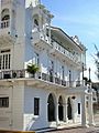
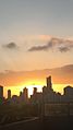
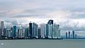
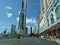
Panama's old quarter, or Casco Viejo, has many different building styles. You can see Spanish colonial buildings, and French and Antillean houses. These were built when the Panama Canal was being constructed. The newer parts of the city have many tall buildings, creating a very dense skyline. There are over 110 tall buildings being built, and 127 are already finished. Panama City ranks 45th in the world for its number of high-rise buildings.
The Centennial Bridge, which crosses the Panama Canal, won an award for its excellent design.
Neighborhoods
The city is in the Panama District. Its wider area also includes some towns on the other side of the Panama Canal. Like the rest of Panama, the city is divided into corregimientos, which are like smaller towns or areas. The old quarter, Casco Viejo, is in the corregimiento of San Felipe. San Felipe and twelve other corregimientos make up the city's main area. These include Santa Ana, El Chorrillo, Calidonia, Curundú, Ancón, Bella Vista, Bethania, San Francisco, Juan Diaz, Pueblo Nuevo, Parque Lefevre, and Río Abajo.

Economy


.jpg)

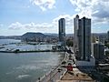
Panama City is the economic and financial heart of the country. Its economy mainly relies on services like banking, business, and tourism. The city's economy is strongly linked to trade and shipping because of the Panama Canal and the port facilities in Balboa. Because the canal brings money from all over the world, the city has become a major place for international banking. This means many accountants and lawyers work here to help global companies. The city has grown a lot recently, thanks to the Panama Canal expansion, more real estate investments, and a stable banking system. There are about eighty banks in the city, with at least fifteen being local.
Panama City produces about 55% of Panama's total economic output. This is because most businesses and offices in Panama are located in the city and its surrounding area. It is a stop for people traveling to other parts of the country, and it is also a popular tourist spot itself.
Tourism is a very important part of the city's economy. This area has grown a lot since the Panama Canal Zone was given back to Panama at the end of the 20th century. The number of hotel rooms increased from 1,400 in 1997 to over 15,000 in 2013. The number of visitors each year also grew from 457,000 in 1999 to 1.4 million in 2011. Many international hotel chains have opened or plan to open new hotels in the city.
New land has been created by filling in parts of the sea. This new land is used for highways, homes, and parks, like the Cinta Costera.
People and Culture

The city has about 1,086,990 people living in its 26 areas. People from Panama City are often called capitalinos. The population is very diverse, with many different backgrounds. There is a lot of cultural variety in the city, and many languages are spoken, such as German, Portuguese, French, Arabic, Chinese, Hebrew, and English, in addition to Spanish.
World Heritage Sites
Panamá Viejo
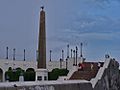
Panamá Viejo ("Old Panama") is the name for the old buildings and ruins of the first Spanish city built on the Pacific coast of the Americas. It was founded by Pedro Arias de Ávila on August 15, 1519. This city was the starting point for trips that conquered the Inca Empire in Peru in 1532. It was also a key stop on one of the most important trade routes in American history. Most of the gold and silver that Spain took from the Americas passed through here.
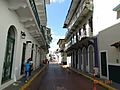
Casco Viejo or Casco Antiguo

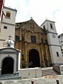
The historic district of Panama City, known as Casco Viejo or Casco Antiguo, was built in 1671. This happened after the destruction of Panama Viejo by the privateer Henry Morgan. It was designed as a walled city to protect people from future pirate attacks. UNESCO named it a World Heritage Site in 2003.
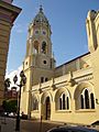
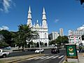
Casco Antiguo shows a mix of building styles, reflecting Panama's diverse culture. You can see Caribbean, Republican, art deco, French, and colonial buildings among its 800 structures. Many of Panama City's main landmarks are in Casco Antiguo. These include the Salón Bolivar, the National Theater (built in 1908), Las Bóvedas, and Plaza de Francia. There are also many Catholic churches, like the Metropolitan Cathedral and the La Merced Church. The special golden altar at St. Joseph Church was one of the few things saved from Panama Viejo during the 1671 pirate attack. It was hidden in mud and then secretly moved to its current spot.
The old quarter is being rebuilt and improved. It has become one of the city's main tourist spots, second only to the Panama Canal. Both the government and private companies are working to restore it. An extension to the Cinta Costera highway, called "Cinta Costera 3," was built around Casco Antiguo in 2014.
There were some protests before the Cinta Costera 3 project was built. People worried that Casco Viejo might lose its World Heritage status. However, on June 28, 2012, UNESCO decided that Casco Viejo would not be put on the list of World Heritage Sites in Danger.
Literature and Art

The first story about Panama was written by Gonzalo Fernández de Oviedo y Valdés in 1535. Many poets and writers have been born in Panama City.
Some important Panamanian artists include Alfredo Sinclair, known for his abstract art, and his daughter, Olga Sinclair. Another famous artist is Guillermo Trujillo, known for his abstract surrealism. Brooke Alfaro is also a well-known Panamanian artist, famous for his oil paintings. Mario Calvit is another great painter from the mid-20th century.
Tourism
_-_Pamama.jpg)

Tourism in Panama City offers many historic sites and places related to the Panama Canal. Some of these places are:
- Las Bóvedas ("The Vaults"), a walkway along the water.
- The National Institute of Culture Building.
- The Cathedral at Plaza de la Catedral.
- Teatro Nacional (National Theatre of Panama), a theater with great sound.
- Museo del Canal Interoceánico (Interoceanic Canal Museum).
- Palacio de las Garzas (Heron's Palace), the official home of Panama's President, named for the many herons there.
- Miraflores Visitors Center at the Miraflores Locks, with a museum and a ship simulator.
- Calzada de Amador (Amador Causeway), a road built with rocks from the Panama Canal digging.
Panama City has many hotels, including luxury ones and smaller, cozy boutique hotels. Nightlife is popular in the Calle Uruguay and Casco Viejo areas, with many bars and nightclubs for visitors.
A newer tourist area is the Amador Causeway, east of the canal's Pacific entrance. This area is becoming a center for tourism and evening fun. The Smithsonian Tropical Research Institute has a small museum open to the public here. A new museum, the Biomuseo, opened on the causeway in 2014. It was designed by the famous American architect Frank Gehry. Just outside the city is the Parque Municipal Summit. A new convention center is also being built in Amador.
Like any big city, it's good to be aware of your surroundings in Panama City.
Sports


Panama City has been great in sports like boxing, baseball, basketball, and soccer. Famous athletes like Roberto Durán (boxing) and Mariano Rivera (baseball) come from here. Today, these sports have clubs and groups that help them grow in the city. Panama Metro is the city's baseball team. There are also many football (soccer) clubs, such as:
- Alianza
- Chorrillo
- Plaza Amador
- Tauro
- Chepo
- San Francisco F.C.
The city has two main stadiums: the National Baseball Stadium (Rod Carew Stadium) and the Rommel Fernández Stadium. They can hold 27,000 and 32,000 people, respectively. The Roberto Durán Arena can hold 18,000 people.
Education
Panama City has both public and private schools. Most private schools teach in both English and Spanish. For higher education, there are two main public universities: the University of Panama and the Technological University of Panama. There are also many private universities. Some U.S. universities, like Florida State University, have branches in Panama City.
Healthcare

Panama City has at least 14 hospitals and many public and private clinics. About 45% of Panama's doctors work in Panama City.
Notable people
Transportation


Panama's main international airport, Tocumen International Airport, is located just outside the city. Two other airports serve Panama City: Panamá Pacífico and Marcos A. Gelabert.
The Panama Metro is a train system in Panama City. It connects the northern and eastern parts of the city to the center. The Metro currently has two lines working, and a third line is being built.
Traffic jams can happen often in Panama City because many people own cars. To help with traffic, the Panama Metro started operating in 2014.
The main bus terminal in Ancon offers buses that travel in and out of the city. Bus service is a very popular way to get around Panama. The terminal serves thousands of passengers every day, including those from other Central American countries.
Panama City also has yellow taxis. Taxis do not use meters; instead, they have set prices based on different zones in the city. Sometimes, taxi drivers might charge more than the usual fare. Ride-sharing apps like InDriver and Cabify are also used. There have been discussions about how new ride-sharing apps fit in with traditional taxis.
International Connections
Panama City is connected with other cities around the world as sister cities. These connections help build friendships and cultural exchange.
 Charleston, United States
 Davao City, Philippines
- Fort Lauderdale, United States
 Guadalajara, Mexico
 Imabari, Japan
 Incheon, South Korea
 Kaohsiung, Taiwan
 Liverpool, England, United Kingdom
 Madrid, Spain
 Medellín, Colombia
- Montería, Colombia
- San Diego, United States
- Taipei, Taiwan
Panama City is also part of the Union of Ibero-American Capital Cities.
Images for kids
-
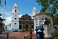
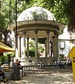
Plaza de la Independencia
-
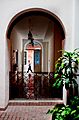
Archway and classic wall in a traditional house
-
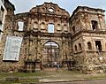
Compañía de Jesús, the ruins of an old convent
-
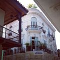
Architecture in Casco Viejo (Old Quarter)
-
The belltower of the San Francisco de Asis Church.
-
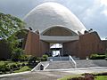
The Bahá'í House of Worship
-
Plaza Bolivar in Casco Viejo
-
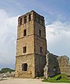
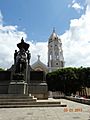
Ruins of the Old Panama Cathedral
-
Santa Ana Park
-
Causeway connecting Naos, Perico, and Flamenco Islands to the mainland
-
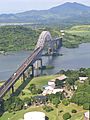
The Bridge of the Americas, at the Pacific entrance to the Panama Canal
-
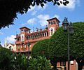
The Palace of the Herons, the official residence and office of the President of Panama
-
Plaza de Francia, a square honoring the French workers and engineers of the Panama Canal.
-
Obario neighborhood seen from San Francisco neighborhood
-
Skyline seen from Casco Viejo
-
The former Balboa Avenue
-
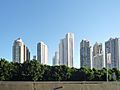
Panama skyscrapers
-
Panama Bay
-
View of part of the metropolitan area of Panama
-
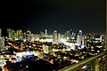
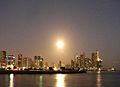
Panama City at night
-
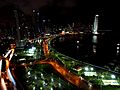
Panama City at night
-
Iglesia Nuestra Sra. del Carmen
-
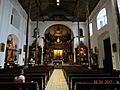
Interior view in Iglesia de la Merced
-
Plaza de Bolivar
-
Iglesia de la Merced
-
Street view
-
Street in old city
-
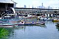
Fishing boats outside Mercado De Marisco Cinta Costera


See also
 In Spanish: Ciudad de Panamá para niños
