Raynolds Expedition facts for kids
Quick facts for kids Raynolds Expedition |
|||||
|---|---|---|---|---|---|
| Part of the Exploration of North America | |||||
 William F. Raynolds |
|||||
|
|||||
| Belligerents | |||||
| Commanders and leaders | |||||
| Strength | |||||
|
33 Soldiers.
|
|||||
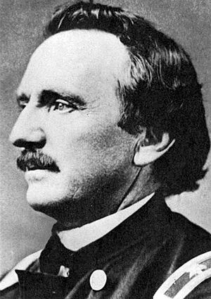
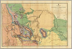
The Raynolds Expedition was a journey by the United States Army to explore and map new lands. It aimed to map the area between Fort Pierre, in what was then Dakota Territory, and where the Yellowstone River begins. Captain William F. Raynolds, a special engineer who mapped land, led this important trip.
Contents
Exploring the American West
In early 1859, Captain Raynolds was given a big job. He had to lead a team into the Yellowstone area of Montana and Wyoming. Their goal was to learn everything they could about the land. This included finding out about the Native American tribes living there. They also looked for farming and mineral resources. The team checked if rivers could be used for boats. They mapped the land's features. This helped them see if it was easy or hard to build roads or railroads.
Who Was on the Team?
The expedition had a small but skilled group of people.
- F.V. Hayden was a geologist and naturalist. He studied rocks, minerals, and nature. He later led more trips to Yellowstone.
- James D. Hutton was a photographer and mapmaker.
- Anton Schönborn was an artist and mapmaker.
- Lieutenant Henry E. Maynadier was Raynolds' second-in-command.
- About 30 soldiers helped protect the group.
- The U.S. Government paid $60,000 for the trip.
- Jim Bridger, a very experienced mountain man, was hired as their guide. He knew the wilderness well.
The Journey Begins: 1859
The expedition started in St. Louis, Missouri in May 1859. The team traveled by two steamboats up the Missouri River. They reached New Fort Pierre, South Dakota. By late June, they left Fort Pierre and went overland. They met the Crow Indians. They explored the Tongue River. Then they headed towards the Yellowstone River in southern Montana.
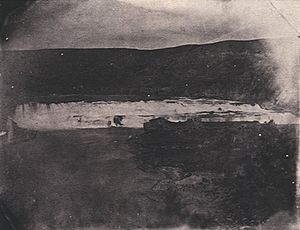
Raynolds split his team into two groups. Maynadier led a smaller group to explore the Tongue River more closely. James D. Hutton and Zephyr Recontre, who spoke the Sioux language, took a side trip. They went to find a unique rock formation. This rock had been seen from far away on an earlier trip in 1857. Hutton was the first person of European descent to reach this rock. It is now known as Devils Tower. Raynolds did not write much about this discovery.
By September 2, 1859, Raynolds' group had followed the Yellowstone River. They reached where it meets the Bighorn River in south-central Montana. The two groups, led by Raynolds and Maynadier, met again on October 12, 1859. They spent the winter at Deer Creek Station. This was on the Platte River in central Wyoming.
Continuing the Exploration: 1860
In May 1860, the expedition started exploring again. Raynolds led his group north and west. They went up the Wind River, which is the upper part of the Bighorn River. Raynolds hoped to cross the Absaroka Range at Togwotee Pass. Their guide, Jim Bridger, knew about this mountain pass.
Meanwhile, Maynadier led his group back north. They explored the Bighorn River and its smaller streams. The plan was for both groups to meet on June 30, 1860. They wanted to be at Three Forks, Montana. This was so they could watch a total solar eclipse on July 18, 1860.
Raynolds' group faced tall cliffs and deep snow. They tried for over a week to get to the top of Togwotee Pass. But they had to go south to meet the June 30 deadline. Bridger then led the group over another pass. Raynolds named it Union Pass. To the west of this pass were Jackson Hole and the Teton Range. From there, the expedition went southwest. They crossed the southern Teton Range at Teton Pass. They entered Pierre's Hole in present-day Idaho.
Raynolds and his group reached Three Forks on time. But Maynadier's group was several days late. This meant they missed the chance to send a team to see the solar eclipse. The reunited expedition then headed home. They traveled by steamboat from Fort Benton, Montana to Fort Union. This fort was near the Montana-North Dakota border. Then they traveled overland to Omaha, Nebraska. The expedition members finished their journey in October 1860.
What the Expedition Achieved
The Raynolds Expedition did not fully explore the area that later became Yellowstone National Park. However, they were the first U.S. Government group to enter Jackson Hole. They were also the first to see the Teton Range. The expedition traveled over 2,500 miles. They explored an area of nearly 250,000 square miles.
In a first report in 1859, Raynolds shared a worrying observation. He said that bison, once very common, were being killed too quickly for their hides. He warned they might soon disappear.
The start of the American Civil War in 1861 and Raynolds' illness delayed his final report. He did not present it until 1868. The expedition's importance was largely forgotten due to the Civil War. The nation's focus shifted away from exploring the West. Because of this, the important geological, mapping, and historical findings of the expedition almost disappeared.
Some plant collections, fossils, and other specimens were meant for the Smithsonian Institution. Their study was delayed. Much of the artwork by Hutton and Schönborn was lost. However, some of Schönborn's chromolithographs appeared in F.V. Hayden's report in 1883. This report came out after later expeditions.
Expedition Leaders
- Captain William F. Raynolds: Commander of the expedition.
- First Lieutenant Henry Eveleth Maynadier: Second in command.
Team Members
- Soldiers:
- A group of 30 men from the 2nd United States Infantry Regiment, led by Second Lieutenant Caleb Smith.
- Later, in 1860, a group of 30 men from the 2nd United States Dragoons replaced the infantry. They were led by Second Lieutenant John Mullins.
- Scientists:
- Doctor Ferdinand Vandeveer Hayden
- Mr. J. Hudson Snowden
- Technicians:
- Anton Schönborn (artist and mapmaker)
- James D. Hutton (photographer)
- James Stevenson
- Thomas Moran
- William Henry Jackson
- Laborers: 7 men
- Guide: James Felix (Jim) Bridger
- Interpreter: Zephyr Recontre (Sioux interpreter)
See also
 In Spanish: Expedición Raynolds para niños
 | James Van Der Zee |
 | Alma Thomas |
 | Ellis Wilson |
 | Margaret Taylor-Burroughs |


