Red Clay State Historic Park facts for kids
Quick facts for kids Red Clay State Historic Park |
|
|---|---|
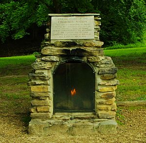
Eternal Flame of the Cherokee Nation
|
|
| Type | Tennessee State Park |
| Location | Bradley County, Tennessee, United States |
| Area | 263 acres (1.06 km2) |
| Established | 1979 |
|
Red Clay Council Ground
|
|
| Lua error in Module:Location_map at line 420: attempt to index field 'wikibase' (a nil value). | |
| Nearest city | Cleveland, Tennessee |
| Area | 150 acres (61 ha) |
| Website | Red Clay Historic State Park |
| NRHP reference No. | 72001229 |
| Added to NRHP | September 14, 1972 |
| Open | Year round |
Red Clay State Historic Park is a special place in southern Bradley County, Tennessee, USA. It protects the Red Clay Council Grounds, which was the last capital of the Cherokee Nation in the eastern United States. This was from 1832 to 1838. During this time, the U.S. government forced most Cherokee people to move far away to what is now Oklahoma. This sad journey is called the Trail of Tears.
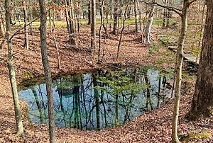
At Red Clay, the Cherokee leaders tried many times to convince the U.S. government to let them stay on their land. The site is very important to the Cherokee people. It includes the Blue Hole Spring, a large natural spring they considered sacred. Red Clay is also a stop along the Trail of Tears National Historic Trail.
After the Cherokee people were forced to leave, the land became private farms. Later, in the 1900s, local historians worked hard to save this important place. They wanted to turn it into a state park. The site was added to the National Register of Historic Places in 1972. Red Clay State Park opened to the public in 1979. It covers about 263 acres (1.06 km2) near the Tennessee–Georgia state line. The park has a museum, copies of old Cherokee buildings, and hiking trails.
Contents
History of Red Clay State Park
The Cherokee People's Story
Long before European settlers arrived, the Cherokee people lived in this area. They spoke an Iroquoian language and are thought to have moved south from the Great Lakes region. Their lands covered parts of what are now North Carolina, South Carolina, East Tennessee, Georgia, and Alabama. The Cherokee in Tennessee were called the Overhill Cherokee. This was because they lived west of the Blue Ridge Mountains.
In the late 1700s and early 1800s, the Cherokee Nation created its own government. It was similar to the U.S. Constitution. European Americans saw them as one of the "Five Civilized Tribes." In 1819, the Cherokee gave up some land to the U.S. government. The main office for U.S. dealings with the Cherokee moved to Charleston in 1821. This town is about 23 miles (37 km) northeast of Red Clay. White settlers then began moving into the area quickly. They expected the Cherokee to be forced to leave.
Between 1827 and 1831, Georgia passed laws against the Cherokee. These laws stopped them from holding meetings and ignored their own laws. In 1830, the U.S. government passed the Indian Removal Act. This law allowed President Andrew Jackson to make treaties to move Native American tribes. Because of these actions, the Cherokee began to leave their capital, New Echota.
In 1832, the Cherokee Nation moved its government to Red Clay permanently. They chose Red Clay because it was easy to reach and had the sacred Blue Hole Spring. By 1836, the site had 91 log buildings.
Cherokee Councils and the Trail of Tears
From 1832 to 1838, eleven big meetings were held at Red Clay. Principal Chief John Ross led these meetings. About 4,000 to 5,000 Cherokee people attended each time. During these meetings, Cherokee leaders went to Washington, D.C. They tried to convince Congress and the President to let them stay. They kept saying no to offers to give up their lands east of the Mississippi River.
While these meetings were happening, a group called the Treaty Party formed within the Cherokee Nation. Leaders like Major Ridge and Elias Boudinot believed they had to move. They thought it was best for the Cherokee people. On December 29, 1835, this group secretly signed the Treaty of New Echota. They did this without permission from the main Cherokee council at Red Clay.
Many Cherokee people saw the Treaty of New Echota as a betrayal. The council at Red Clay rejected it on February 2, 1836. Later that month, two councils gathered and made lists of about 13,000 Cherokees who opposed the treaty. These lists were sent to Washington, D.C., by John Ross. But on May 23, 1836, the U.S. Senate approved a slightly changed version of the treaty. President Andrew Jackson signed it into law.
The treaty gave the Cherokee until May 1838 to move voluntarily. To prevent any trouble, soldiers were sent near Red Clay in mid-1836. The last council at Red Clay was in August 1837. Here, the Cherokee made one final effort to keep their lands, but it was unsuccessful. The Cherokee removal officially began on May 26, 1838. This forced journey became known as the Trail of Tears.
Red Clay State Park Today
In the late 1950s, local historians began working to save the Red Clay Council Grounds. They wanted to turn the private land into a state park. James F. Corn bought 150 acres of the land in 1964. The Cherokee-Red Clay Association was then formed. In 1970, Corn agreed to sell the land to Bradley County for a tourist attraction.
Bill Jenkins, a state official, worked with Governor Winfield Dunn to get money for the park. The Red Clay Council Grounds were added to the National Register of Historic Places on September 14, 1972. The state of Tennessee bought most of the land for the park in 1974. Red Clay State Historic Park opened to the public on September 28, 1979.
Important Events at the Park
The Eternal Flame of the Cherokee Nation was placed at the park on April 6, 1984. This flame is a memorial to the Cherokee people who suffered during the removal. It was the first time the Eastern Band of Cherokee Indians and the Cherokee Nation of Oklahoma reunited since the removal. In 2015, all three federally recognized Cherokee tribes met at Red Clay for the first time since the removal.
The park has also hosted many events. From 1982 to 2001, the Cherokee Days of Celebration (later called the Cherokee Cultural Celebration) was held here. This festival shows off Cherokee culture and history. A nonprofit group, Friends of Red Clay, also hosted an annual pow-wow until 2019. Part of a PBS documentary series, We Shall Remain, was filmed at the park in 2008. A new sign for the Trail of Tears National Historic Trail was put up in 2018. The park's museum was updated in 2021, and a blacksmith shop was added in June 2023.
What You Can See at Red Clay
Red Clay State Historic Park covers about 263 acres (1.06 km2) in a rural part of Bradley County, Tennessee. It sits near the Tennessee–Georgia state line. The park is in the Ridge and Valley Appalachians area of the Appalachian Mountains. The land goes from about 800 feet (244 m) where the council grounds were, to over 1,050 feet (320 m) on a ridge. Most of the park is covered in forests.
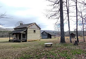
At the council grounds, you can see copies of Cherokee buildings. These include a farmstead, sleeping huts, a blacksmith shop, and the council house. These buildings show what the original structures might have looked like. The park also has the famous Blue Hole Spring, which the Cherokee called the Council Spring. This spring is known for its deep blue color. It provides a lot of water each day, which flows into Coahulla Creek. The Eternal Flame of the Cherokee Nation is also here. It is always lit to remember the Cherokee people.
The James F. Corn Interpretive Center is the park's museum. It has exhibits about Cherokee culture, government, and history from the 1700s and 1800s. You can see stained glass windows that show the forced removal of the Cherokee. There is also a short film about the park's history.
The park has three trails for hiking:
- The Connector Trail (0.15 miles or 0.24 km)
- The Blue Hole Trail (0.2 miles or 0.32 km)
- The Council of Trees Trail (1.7 miles or 2.7 km)
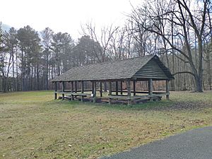
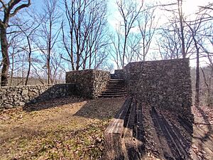
The Council of Trees Trail goes up a ridge and has a stone overlook tower. The park also has picnic areas, a pavilion, and an amphitheater for about 500 people.
See also
 | Bessie Coleman |
 | Spann Watson |
 | Jill E. Brown |
 | Sherman W. White |


