
Salt River (Arizona) facts for kids
Quick facts for kids Salt River |
|
|---|---|

Map of the Salt River watershed
|
|
| Country | United States |
| State | Arizona |
| Counties | Gila & Maricopa |
| Physical characteristics | |
| Main source | Confluence of White and Black Rivers White Mountains, Arizona 11,400 ft (3,500 m) 33°44′20″N 110°13′32″W / 33.73889°N 110.22556°W |
| River mouth | Gila River Phoenix 928 ft (283 m) 33°22′52″N 112°18′47″W / 33.38111°N 112.31306°W |
| Length | 200 mi (320 km) |
| Basin features | |
| Basin size | 13,700 sq mi (35,000 km2) |
The Salt River is a river in Arizona, United States. It flows through Gila and Maricopa counties. It is the biggest river that flows into the Gila River.
The Salt River is about 200 miles (320 km) long. Its drainage basin, which is the area of land where water drains into the river, is about 13,700 square miles (35,000 km2). The longest river that flows into the Salt River is the Verde River, which is 195 miles (314 km) long. The Salt River gets its name because it flows over large salt deposits after its two main starting rivers, the White River and Black River, join together.
Contents
What the Salt River is Called
The Salt River has had a few different names over time. Some of these names include:
- Assumption
- Black River
- Blue River
- Rio Asuncion
- Rio de la Asuncion
- Rio Salado
- Salinas
Where the Salt River Flows

The Salt River starts where the White River and the Black River meet. This meeting point is in the White Mountains in eastern Gila County. These two rivers, along with other smaller streams, collect water from the mountains and plateaus nearby.
The White and Black rivers flow through the Fort Apache Indian Reservation. The Salt River itself forms a border between the Fort Apache Indian Reservation to the north and the San Carlos Apache Indian Reservation to the south. Many small streams that flow all year round, called perennial streams, feed into the Salt River. These streams start from springs in the mountains. The Salt River flows all year from its start until it reaches the Granite Reef Diversion Dam near Mesa.
From where the Black and White rivers meet, the Salt River generally flows west and southwest. It is joined by Carrizo Creek, a 25-mile (40 km) stream. Then it flows through the Salt River Canyon Wilderness. Another stream, Cibecue Creek, which is 36 miles (58 km) long, joins the river in the canyon.

Further downstream, Canyon Creek, which is 46 miles (74 km) long, and Cherry Creek also join the Salt River. A special area called the Salt River Canyon Wilderness is located along the river. The Salt River forms the edge of this wilderness for several miles.
After leaving the Salt River Canyon Wilderness, the river flows through the Tonto National Forest. It then leaves the mountains near Mesa. The Salt River then enters Theodore Roosevelt Lake. This is the first of four large lakes, called reservoirs, on the river. Tonto Creek also flows into Theodore Roosevelt Lake.
Below Theodore Roosevelt Dam, the Salt River flows through a canyon between the Mazatzal Mountains and the Superstition Mountains. Here, it is held back by three more dams: Horse Mesa Dam (forming Apache Lake), Mormon Flat Dam (forming Canyon Lake), and Stewart Mountain Dam (forming Saguaro Lake).
These four reservoirs are part of the Salt River Project. This project helps provide water for drinking, industry, and farming to the Phoenix metropolitan area. The reservoirs can hold a lot of water: Roosevelt Lake holds 2,910,200 acre-feet, Apache Lake holds 245,100 acre-feet, Canyon Lake holds 57,900 acre-feet, and Saguaro Lake holds 69,800 acre-feet.

As the Salt River flows through these lakes, it passes near the Four Peaks Wilderness. A few miles below the last dam, Stewart Mountain Dam, the Verde River joins the Salt River from the north. The Salt River Pima–Maricopa Indian Community is located near where the Verde and Salt rivers meet.
The Tonto National Forest ends a few miles below the Verde River, and the Salt River enters the eastern part of the Phoenix area. Very close to the forest boundary, the Granite Reef Diversion Dam takes almost all the remaining water from the Salt River. This water goes into the Arizona Canal and Southern Canal. These canals deliver drinking and irrigation water to much of the Phoenix area. The dam and canals are also part of the Salt River Project.
Below this dam, the Salt River bed is usually dry. It only has water after heavy rains or when water is released from the dams upstream. For example, in 2009, the river was dry for most of the year in Phoenix. The dam can divert a huge amount of water: 3,600 cubic feet per second (100 m3/s).
The Salt River then flows past the cities of Mesa, Tempe, and Scottsdale. It then goes south of downtown Phoenix. Except for Tempe Town Lake, the riverbed through these cities is usually dry. Water only flows when heavy rains upstream force the dams to release more water than can be diverted. The Salt River finally joins the Gila River on the southwestern edge of Phoenix.
How the River Has Changed
The Salt River used to flow all year long. But it would often flood. To control flooding, several dams were built, starting with the Theodore Roosevelt Dam. Because of these dams, parts of the river now only flow sometimes, not all year.
Even though the riverbed is often dry, dangerous flash floods can still happen. This is especially true during monsoon storms in late July and early August. These floods can wash out roads and damage bridges. The river was once used for farming by ancient people called the Hohokam and later by other Native Americans. Today, it is a main source of water for Phoenix and nearby communities through the Salt River Project. The river's water is sent through over 1,000 miles (1,600 km) of canals. This water is used to grow crops like cotton, alfalfa, fruits, and vegetables.
Animals in the Salt River Area
North American beavers used to live in large numbers along the Salt River. A fur trapper named George C. Yount wrote in 1863 that he found many beavers along the river.
Water Quality
Sometimes, the water in the Salt River's watershed (the area that drains into the river) can be cloudy. This can be caused by things like ranching, recreation, mining, and sand and gravel operations. High levels of certain bacteria and ammonia have also been found in some streams like Carrizo Creek and the White River.
History of the Salt River
The Spanish people who explored this area long ago called the river Río Salado. In ancient times, a group of people known as the Salado culture lived along the river.
Fun Activities on the Salt River

There are places to enjoy the Salt River, especially for boating and fishing.
Boating and Camping Areas
- Cherry Creek to Roosevelt Lake: You can reach this area by paved roads, gravel roads, and trails. You can use live bait fish (but check for rules). No motors are allowed on boats here. There are simple parking areas and you can camp. Much of this area is hard to reach.
- Below Saguaro Lake: This area has paved and dirt access. You can use live bait fish, and swimming is allowed. No motors are allowed. There are parking areas, tables, restrooms, and camping spots. Several camp and picnic areas are here, but they are often drained in winter.
These areas are managed by the Tonto National Forest.
- Tempe Town Lake: At Tempe Town Lake, you can rent small boats like kayaks, pedal boats, electric pontoon boats, and fishing boats. This is run by a private company, not the City of Tempe.
Fish You Might Find
- Cherry Creek to Roosevelt Lake (15 miles where you can fish): You might catch largemouth bass, smallmouth bass, sunfish, channel catfish, flathead catfish, and carp.
- Below Saguaro Lake (11 miles where you can fish): Here you might find rainbow trout, largemouth bass, smallmouth bass, yellow bass, crappie, sunfish, channel catfish, flathead catfish, blue catfish, yellow perch, walleye, tilapia, black crappie, carp, bullfrogs, and desert sucker.
Images for kids
-

Rio Salado south of Stewart Mountain Dam
-
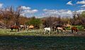
Wild horses grazing on the banks of the Rio Salado
-
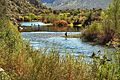
Recreation on the Rio Salado


See also
 In Spanish: Río Salado (Arizona) para niños
