
San Pedro River (Arizona) facts for kids
Quick facts for kids San Pedro River |
|
|---|---|
.jpg)
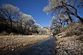
San Pedro Riparian National Conservation Area
January 2010 |
|

Map of the Gila River watershed including the San Pedro River
|
|
| Other name(s) | Rio San Pedro, Beaver River |
| Country | Mexico, United States |
| State | Sonora, Arizona |
| Physical characteristics | |
| Main source | The Sierra Manzanal Mountains in northern Sonora North of Cananea, Mexico, Mexico 4,460 ft (1,360 m) 31°12′04″N 110°12′28″W / 31.20111°N 110.20778°W |
| River mouth | Confluence with the Gila River Winkelman, Arizona, Pinal County, United States 1,919 ft (585 m) 32°59′04″N 110°47′01″W / 32.98444°N 110.78361°W |
| Basin features | |
| Tributaries |
|
The San Pedro River is a stream that flows north. It starts about 10 miles (16 km) south of the border between the United States and Mexico. Its source is in Sonora, Mexico, near Cananea Municipality. The river begins where two other streams, Las Nutrias and El Sauz, meet.
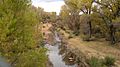
In Arizona, the San Pedro River flows for 140 miles (230 km) north. It passes through Cochise, Pima, Graham, and Pinal counties. It eventually joins the Gila River at Winkelman, Arizona. This river is special because it is the last major desert river in the American Southwest that has not been dammed. It is very important for nature. Two-thirds of all bird types in the United States can be found here. This includes 100 kinds of birds that nest here and almost 300 kinds of birds that migrate through.
Contents
San Pedro River: A Journey Through Time


The San Pedro Valley has a long and interesting history. The first people to live here were the Clovis people. They hunted large animals like mammoths about 10,000 years ago. This valley has more Clovis sites than any other place in North America. Important Clovis sites include the Lehner Mammoth-Kill Site and the Naco Mammoth-Kill Site.
Ancient Cultures and Early Explorers
After the Clovis people, the Cochise Culture lived here from about 5000 to 200 BC. They were hunter-gatherers. Later, more advanced groups like the Mogollon, Hohokam, and Salado built permanent homes. They also farmed the land. By the time the first Europeans arrived, these cultures had disappeared. The Sobaipuri people then lived along the San Pedro River.
Some of the first Europeans to visit the San Pedro River might have been Cabeza de Vaca or Coronado. While there is no proof yet, it is believed that the upper San Pedro was a well-known path called the "Cibola Trail." In 1692, a priest named Eusebio Kino visited the villages along the San Pedro and Babocomari Rivers. He brought the first livestock to this area.
Later Settlers and Changes to the River
Many people thought that the Apache drove the Sobaipuri and Spanish out of the valley by 1762. However, new studies show this is not true. Documents say that some Sobaipuri stayed. Archaeology has also found more Sobaipuri settlements from the 1800s.
Early American explorers came to the San Pedro River looking for beaver pelts. In 1826, James Ohio Pattie and his group traveled down the river. They found so many beavers that Pattie called it the Beaver River.
The Mormon Battalion marched through the valley in 1846. They had a small fight with wild cattle near the river. Later, in 1877, Mormon settlers came back. They started a town called St. David. They also cut down trees from the Huachuca Mountains to build Fort Huachuca and Tombstone.
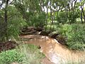
In the 1800s, the river was full of beaver ponds and wet areas. But the climate became warmer and drier. Also, beavers were removed, and many cattle were brought in. The river then became wider and cut deeper into the land. By the mid-1900s, the river often dried up. Beavers and wet areas became rare.
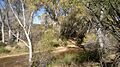
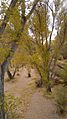
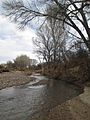
San Pedro River: A Home for Wildlife
.jpg)
The San Pedro River is a very important natural area. It is part of the Madrean Archipelago, which are like "Sky Islands." These are high mountains with special ecosystems. They are different from the desert around them.
Amazing Animals of the River
More than 300 types of birds either nest by the river or use it as a path. They migrate between South, Central, and North America. One example is the yellow-billed cuckoo. The area is also home to over 80 types of mammals. These include the jaguar, coatimundi, and beaver. There are also 20 types of bats and many kinds of rodents.
Over 65 types of reptiles and amphibians live here. Some are the Sonoran tiger salamander and the western barking frog. Important native fish include the endangered Gila chub, longfin and speckled dace, and the roundtail chub.
Plants of the Riverbanks
The plants along the river include Fremont cottonwood trees and Goodding willow trees. You can also find velvet mesquite trees. The Huachuca water umbel is a federally endangered plant found here.
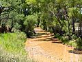
Protecting the River's Future
In recent years, more people have moved to southern Arizona. This has caused worries about the river. Many groups are now working to protect it. The San Pedro Riparian National Conservation Area (SPRNCA) was created in 1988. It protects about forty miles of the upper San Pedro valley.
The Nature Conservancy also owns several protected areas in the region. One of these is Rancho Los Fresnos. It is the largest ciénega (a desert spring or marsh) left in the San Pedro River area. Protecting it is very important. This is because 99% of these special desert wetlands have been lost.
.jpg)
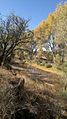
Many parts of the river are dry for much of the year. A wildlife biologist named Mark Fredlake suggested bringing beavers back. He believed that beaver dams would help keep water in the river longer. This would also help the plants along the river grow back. These riverbank areas are very important. They cover only 1% of the Southwest but support 50% of all breeding bird species.
From 1999 to 2002, 19 beavers were released into the SPRNCA. This is a 40-mile (64 km) stretch of the river. By 2006, there were over 30 beaver dams. The beavers spread out quickly. Some even traveled over 100 miles! The program worked well. There were more types of birds, and the river had deeper pools and flowed longer. Even after a flood destroyed the dams in 2008, the beavers returned. By 2009, there were more than 30 dams again.
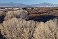
The San Pedro River Watershed


The San Pedro River collects water from an area of about 4,720 square miles (12,200 km2). This area includes Cochise, Graham, Pima, and Pinal Counties. The river flows through deep valleys. Mountains like the Huachuca and Dragoon are on its sides.
Many smaller streams flow into the San Pedro River. These streams usually drain short, steep areas. For most of its path, the San Pedro flows over soft ground. However, it is surrounded by rock in a few places. Two important streams that feed the San Pedro are the Babocomari River and Aravaipa Creek.
Images for kids
-
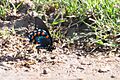
Pipevine Swallowtail Butterfly
-
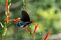
Pipevine Swallowtail Butterfly
-
-
-
-
-
-
-
-
-
-
.jpg)
.jpg)


.jpg)
.jpg)

.jpg)


.jpg)
.jpg)
See also
 In Spanish: Río San Pedro (Arizona) para niños
