Shankill Road facts for kids
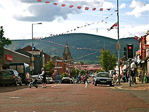
Divis Mountain from the Shankill
|
|
| Other name(s) |
|
|---|---|
| Part of | B39 |
| Namesake | from Irish: Seanchill, meaning "old church" |
| Maintained by | Transport NI |
| Length | 2.4 km (1.5 mi) |
| Location | Belfast |
| Postal code | BT13 |
| Coordinates | 54°36′15″N 5°57′11″W / 54.6043°N 5.9530°W |
| West end | Woodvale Road |
| East end | Peter's Hill |
| Other | |
| Known for | Ulster Loyalism, Murals |
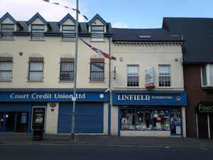
The Shankill Road (from the Irish Seanchill, meaning "old church") is a major road in West Belfast, Northern Ireland. It runs through an area mostly made up of working-class people who are mainly loyalist. Loyalists are people who want Northern Ireland to remain part of the United Kingdom.
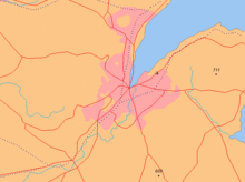
The road stretches west for about 2.4 kilometers (1.5 miles) from central Belfast. It has many shops along its length. People live in the many smaller streets that branch off the main road. The area around Shankill Road is part of the Court district electoral area.
In the Ulster-Scots language, it is called Auld Kirk Gate ("Old Church Way") or Auld Kirk Raa ("Old Church Road"). In the Irish language, it is known as "Bóthar na Seanchille" ("the road of the old church").
Contents
History of Shankill Road
The first people to live in the Shankill area were ancient settlers. They built a ring fort where the Ballygomartin and Forth rivers meet. This was at the bottom of what is now called Glencairn.
The name Shankill comes from the Irish words Seanchill, meaning "old church". This church is believed to have been built around 455 AD. It was known as the "Church of St Patrick of the White Ford". It was an important place for religious journeys. By the 17th century, the church was in ruins, and by the 19th century, it had completely disappeared. Only its graveyard remained. An old stone from the church, called a bullaun stone, is now at St Matthew's on Woodvale Road. People say it can heal warts.
The Shankill Road became a paved road around the 16th century. At that time, it was part of the main road to Antrim. Today, the A6 fills that role. The lower parts of Shankill Road used to be the edge of Belfast. Streets like Boundary Street and Townsend Street got their names because they marked the end of the city when they were built.
The area grew a lot in the mid-to-late 1800s. This was because of the growing linen industry. Many streets in the Shankill area, like Leopold Street, Cambrai Street, and Brussels Street, were named after places in Belgium or Flanders. This is where the flax used for linen was grown. In the mid-20th century, the linen industry and other local businesses declined. This led to many people losing their jobs. The Harland and Wolff shipyard, which also employed many people from the area, has also seen fewer workers in recent years.
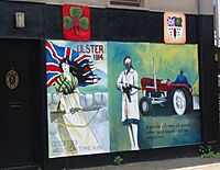
The Shankill area also saw conflicts in the 1800s. These often involved groups with different political or religious beliefs. The West Belfast Division of the original Ulster Volunteer Force (UVF) trained in Glencairn. Some of its members fought in the First World War with the 36th (Ulster) Division. A garden of remembrance and a mural on Conway Street remember those who fought. Many people also joined up during the Second World War. During the Belfast Blitz, a German bomb hit a shelter on Percy Street, causing many deaths. The Duke and Duchess of Gloucester visited the damaged site.
The Troubles and the Shankill
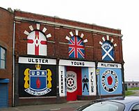
During the Troubles, a period of conflict in Northern Ireland, the Shankill was a center for loyalist groups. The modern Ulster Volunteer Force (UVF) started in the Shankill area. They were involved in various attacks, and sadly, people were killed.
The Ulster Defence Association (UDA) also began in the Shankill in 1971. Local defense groups joined together to form this larger organization. The Shankill Road became the main base for the UDA.
The Greater Shankill area and its residents also experienced bombings and shootings by Irish republican groups. In 1971, two pubs on the Shankill were bombed, injuring and killing people. Another bomb at the Balmoral Furnishing Company killed four people, including two babies. The Mountainview Tavern was attacked again in 1975, leading to more deaths and injuries. On 13 August 1975, the IRA attacked the Bayardo Bar, killing five people.
The Shankill Road bombing happened on 23 October 1993. A bomb exploded in Frizzell's Fish Shop. Nine people were killed, along with one of the bombers. The loyalist paramilitaries who were the target were not hurt because they had changed their meeting time.
Eight months after the fish shop bombing, members of the Irish National Liberation Army (INLA) shot and killed three UVF members and injured a civilian outside the Progressive Unionist Party headquarters.
Areas of the Shankill Road
Lower Shankill
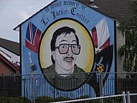
The Shankill Road starts at Peter's Hill, which connects to North Street in Belfast city centre. The area of housing on the lower Shankill around Agnes Street was sometimes called "The Hammer." This name is remembered in the Hammer Sports Complex, home to the football team Shankill United F.C.. The Lower Shankill has been rebuilt in recent years. The Shankill Women's Centre, which helps women with education, is also located here.
Some streets connect the Shankill Road to the nearby Crumlin Road. The area around North Boundary Street was once a stronghold for a UDA group. Murals in the area remember members who have died. The Shankill also connects to the nearby Falls Road at a few points. However, most of these connections are blocked by peace lines, which are walls or barriers built to separate communities. The entrance at Northumberland Street is sometimes open but has gates that are locked at night.
The Lower Shankill has many loyalist pubs. The "Royal Bar" is linked to the UVF, and the "Diamond Jubilee" was a UDA meeting place.
Middle and Upper Shankill
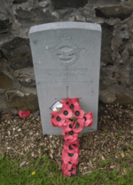
There isn't a clear line between the Lower, Middle, and Upper Shankill, but the lower Shankill is usually said to end at Agnes Street. This area was redeveloped earlier than the lower Shankill. Several Protestant churches are in this area, including the West Kirk Presbyterian Church and the Shankill Methodist church.
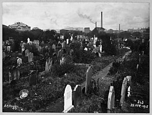
The West Belfast Orange Hall is near the top of the road. This building has been updated by Belfast City Council. The nearby Shankill Cemetery is a small graveyard that has been used for burials for about 1000 years. It has a statue of Queen Victoria and a memorial to members of the 36th Ulster Division who died at the Battle of the Somme. Among those buried here is Rev Isaac Nelson, a Presbyterian minister who was also involved in politics.
The area includes Lanark Way, which is one of the few direct links to nearby nationalist areas. It leads to the Springfield Road, though it has gates that are locked at night.
Several pubs in this area were used by UVF members, such as the "Berlin Arms" and the "Bayardo." The "Brown Bear" pub, which was used by a loyalist group, has since been torn down. The "Rex Bar" on the middle Shankill is one of the oldest pubs on the road and is still open.
Greater Shankill
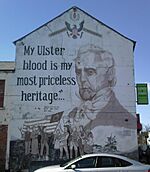
The term "Greater Shankill" refers to the Shankill Road and the surrounding unionist/loyalist areas. These areas include Woodvale, Glencairn, and Highfield. The Greater Shankill as a whole has about 22,000 people.
Woodvale
The Woodvale area starts after Lanark Way, where Shankill Road becomes Woodvale Road. It has many houses and the Woodvale Presbyterian Church, built in 1899. The area is named after Woodvale Park, a public park and sports area opened in 1888.
Also here is St. Matthew's Church of Ireland, rebuilt in 1872. It is named after the original church that was in the Shankill graveyard. The church's design is called trefoil, meaning it is shaped like a shamrock. The oldest stone in the Shankill graveyard was known as the "Bullaun Stone." It was moved to St Matthew's in 1911.
Glencairn
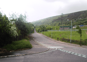
Glencairn is an area around the Ballygomartin Road and Forthriver Road. It is next to the Crumlin Road. Besides a large housing estate, it has Glencairn Park, a big wooded area at the bottom of Divis Mountain. This park was opened to the public in 1962. The park includes Fernhill House, an old family home. This house was used by Edward Carson to train his Ulster Volunteers. It was also where the Combined Loyalist Military Command (CLMC) announced their ceasefire in 1994. It later became a museum but closed around 2010-2011.
Highfield
Highfield is a housing estate located around the West Circular and Springmartin Roads. These roads branch off Ballygomartin Road. Highfield is close to the nationalist Springfield Road, and there is some access between the two areas. Because of its location, parts of Highfield are sometimes called the Springmartin estate. Highfield has seen some sectarian tension. As a result, Springmartin Road has an 18-foot (5.5-meter) high peace line. This wall runs along the road from Springfield Road to Ballygomartin Road. In May 1972, the area was the site of a two-day gun battle between republican and loyalist groups and the British Army. The peace line helped prevent such open conflict later during the Troubles.
Education
Secondary schools that serve the Shankill area include the Belfast Boys' Model School and Belfast Model School for Girls. These schools are located in the Ballysillan area, near the Crumlin Road. Students from the area also attend integrated schools like Hazelwood College or Malone College. Some also go to grammar schools such as Victoria College and the Royal Belfast Academical Institution. A former local school, Mount Gilbert Community College, closed in 2007. Famous students from the area include footballer Norman Whiteside and boxer Wayne McCullough.
Primary schools in the greater Shankill area include Forth River Primary School on Ballygomartin Road. A new building for this school was opened by Prince Andrew, Duke of York in 2005. Other primary schools on the Shankill Road itself are Glenwood Primary School, Edenbrooke Primary School, and Malvern Primary School. Black Mountain Primary School and Springhill Primary School are on Springmartin Road.
Sport
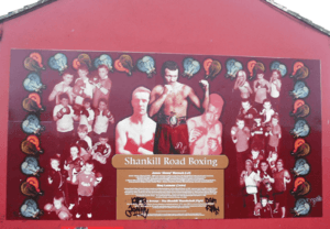
Wayne McCullough, a gold medalist at the Commonwealth Games and a world champion boxer, is from the Shankill. He also won an Olympic silver medal at the 1992 Summer Olympics for Ireland. He is one of several boxers from the area featured on a mural celebrating the area's strong boxing history. The mural is now on Hopewell Crescent. McCullough trained at the Albert Foundry boxing club in the Highfield estate where he grew up. Other local boxers who made an impact include Jimmy Warnock and his brother Billy.
Football is also very popular in the area. Local teams include Shankill United, Albert Foundry, Lower Shankill, and Woodvale. All these clubs are part of the Northern Amateur Football League. The main football club supported in the area is Linfield, even though their home ground is in south Belfast. An Ulster Rangers social club is also on the road, as the Glasgow team is widely supported by Northern Irish Protestants. Norman Whiteside, a former Northern Ireland and Manchester United player, lived on the Shankill. A community sports area, the Norman Whiteside Sports Facility, is named after him. George O'Boyle, who played football in Scotland for many years, is also from Shankill.
The Ballygomartin Road also has a cricket ground. In 2005, it hosted a professional cricket match. The ground is home to Woodvale Cricket Club, which was started in 1887.
Transport
The Shankill Road was once part of the main road to Antrim, but it is no longer a major route connecting Belfast to other towns. Its side roads either end in the mountains or connect to the Springfield Road. Belfast used to have a network of trams in the first half of the 20th century. The Shankill was the last part of the city to lose this service in the 1950s. Today, public transport is provided by Translink's Metro buses. Buses connect Belfast City Centre to the estates at the top of the Shankill and the Ballysillan area of the Crumlin Road.
Employment
- Mackie International was once a very important factory in Belfast. It employed thousands of men and women.
Shankill Graveyard
The Shankill Graveyard is one of the oldest cemeteries in the Greater Belfast Area. It was used for burials for over 1,000 years, but it is no longer an active burial site. George McAuley, who died in 1685, has one of the oldest readable gravestones in the cemetery.
Notable Residents
| Name | Area | Connection to the Greater Shankill |
|---|---|---|
| Norman Whiteside | Footballer | Born |
| Wayne McCullough | Boxing | Born |
| George O'Boyle | Football | Born |
| Davy Larmour | Boxer | Born |
| George McCartney | Footballer | Born |
| Phil Gray | Footballer | Born |
| Kirk Hunter | Footballer | Born |
| Marco McCullough | Boxer | Born |
| Jimmy Warnock | Boxer | Born |
| Tommy Waite | Boxer | Born |
| Terry Bradley | Artist | Born |
| Billy Ferguson | Footballer | Born |
| Billy Hull | Activist | Born |
| May Blood, Baroness Blood | Activist | Born |
| John MacQuade | Politician | Born |
| Jack Higgins | Author | Lived |
| Isaac Nelson | Clergy | Nelson Memorial Church, Shankill Road |
| Amy Carmichael | Missionary | Established a mission on Belfast's Shankill Road |
| Hugh Smyth | Politician | Born |
| Billy Hutchinson | Politician | Born |
| James Mackie & Sons | Business | Business |
| Tommy Henderson | Politician | Born |
| William Conor | Artist | Greater Shankill Area |
| Desmond Boal | Politician | Lived |
| Robert McCartney (Northern Irish politician) | Politician | Born |
| Bernard McQuirt - Victoria Cross | Soldier | Lived |
| Thomas Paul Burgess | Author | Born |
See also
 In Spanish: Shankill Road para niños
 | Sharif Bey |
 | Hale Woodruff |
 | Richmond Barthé |
 | Purvis Young |


