Shavers Fork Mountain Complex facts for kids
Quick facts for kids Shavers Fork Mountain Complex |
|
|---|---|

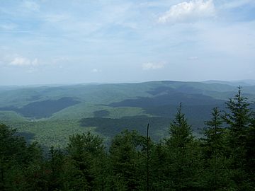
View from Gaudineer Knob on Shavers Mountain
|
|
| Highest point | |
| Peak | Thorny Flat (Pocahontas County, West Virginia) |
| Elevation | 4,848 ft (1,478 m) |
| Prominence | 720 ft (220 m) |
| Geography | |
| Country | United States |
| Settlement | Durbin |
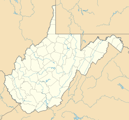
| Range coordinates | 38°36′55″N 79°50′39″W / 38.61528°N 79.84417°W |
The Shavers Fork Mountain Complex is a group of mountains in West Virginia, USA. These mountains are found in Randolph, Pocahontas, and Tucker counties. They are located on both sides of the Shavers Fork river. A large part of this area, about 20,000 acres (81 km2), is protected as a special wilderness area within the Monongahela National Forest.
Contents
Exploring the Mountains of Shavers Fork
The Shavers Fork Mountain Complex includes several important mountain ridges. These ridges help shape the landscape and rivers of West Virginia.
Discover Cheat Mountain
Cheat Mountain runs along the western side of the Shavers Fork river. It stretches from Thorny Flat in Pocahontas County all the way north to Parsons in Tucker County. This long mountain ridge separates the Shavers Fork valley from the Tygart Valley River valley.
Highest Point on Cheat Mountain
The highest point on Cheat Mountain is Thorny Flat. Another important spot is White Top. This is where the Staunton-Parkersburg Turnpike (now U.S. Route 250) crosses the mountain. During the American Civil War, a fort was built here. It was the highest fort used by the Union Army in the war.
Shavers and Back Allegheny Mountains
Shavers Mountain and Back Allegheny Mountain are part of the same mountain ridge. This ridge follows the eastern side of the Shavers Fork river. It also runs from Pocahontas County into Tucker County.
Understanding the Ridge Names
- North of U.S. Route 250, this ridge is called Shavers Mountain.
- South of U.S. Route 250, it is known as Back Allegheny Mountain.
This ridge is important because it separates two major river systems. The water from Shavers Fork eventually flows into the Monongahela River. The water from the other side of the ridge flows into the Greenbrier River, which then joins the Kanawha River.
Notable Spots on the Ridge
One famous high point on Back Allegheny Mountain is Bald Knob. It is one of the highest places in West Virginia. Just north of US 250 on Shavers Mountain is Gaudineer Knob. This spot offers amazing views of the Shavers Fork Mountain Complex. It is also home to the Gaudineer Scenic Area, which protects a special forest of spruce trees.
Other Mountains in the Complex
Several other nearby mountains are also considered part of the Shavers Fork Mountain Complex. These include:
- Bickle Knob
- McGowan Mountain
- Elk Mountain
- Middle Mountain
History of the Shavers Fork Area
In the early 1900s, the Shavers Fork area was heavily logged. This happened after new railways, like the Western Maryland Railway and a branch of the Chesapeake and Ohio Railway to Durbin, made it easy to transport timber. By the 1930s, much of the land had lost almost all its trees. This led to big floods and fires in the remaining forests.
Reforestation Efforts
Starting in the 1930s, a major effort began to replant trees. This work was done by the Civilian Conservation Corps (CCC) as part of the Monongahela National Forest projects. The CCC was a program during the Great Depression that put young men to work on conservation projects.
Weather in the Shavers Fork Mountains
The mountains in this area, especially Cheat and Back Allegheny, are known for their challenging weather. Winters can be very harsh. West Virginia's lowest temperatures and heaviest snowfalls have happened here.
Typical Weather Conditions
- From November to April, strong storms and very cold temperatures are common.
- It has even snowed on the highest peaks as early as mid-September and as late as June 7.
- Freezing temperatures and frost can happen in any month of the year.
- Above 4,000 feet (1,200 m), ice often builds up on trees and objects, called rime ice.
- A common saying about the weather here is: "If you don't like the weather, wait 10 minutes and it will change."
 | Bayard Rustin |
 | Jeannette Carter |
 | Jeremiah A. Brown |


