
Shelby, North Carolina facts for kids
Quick facts for kids
Shelby, North Carolina
|
||
|---|---|---|
|
City
|
||

City hall
|
||
|
||

Location of Shelby, North Carolina
|
||
| Country | United States | |
| State | North Carolina | |
| County | Cleveland | |
| Named for | Isaac Shelby | |
| Area | ||
| • Total | 22.39 sq mi (57.98 km2) | |
| • Land | 22.35 sq mi (57.90 km2) | |
| • Water | 0.03 sq mi (0.09 km2) | |
| Elevation | 873 ft (266 m) | |
| Population
(2020)
|
||
| • Total | 21,918 | |
| • Estimate
(2022)
|
21,855 | |
| • Density | 980.50/sq mi (378.57/km2) | |
| Time zone | UTC−5 (Eastern (EST)) | |
| • Summer (DST) | UTC−4 (EDT) | |
| ZIP codes |
28150-28152
|
|
| Area code | 704, 980 | |
| FIPS code | 37-61200 | |
| GNIS feature ID | 2405454 | |
| Website | cityofshelby.com | |

Shelby is a city in Cleveland County, North Carolina. It is the main city of the county. Shelby is located near the western edge of the larger Charlotte metropolitan area. In 2020, about 21,918 people lived in Shelby.
Contents
History of Shelby
Early Beginnings and Naming
The area where Shelby now stands was first home to the Catawba and Cherokee tribes. Settlers from Europe arrived around 1760. The city of Shelby was officially created in 1843. It was named after Colonel Isaac Shelby. He was a hero of the Battle of Kings Mountain in 1780, which happened during the American Revolution.
Growth and Industry
For many years, Shelby was mainly a farming community. But in the 1870s, railways came to the city. This helped Shelby grow and develop.
In the 1920s, textile factories became very important. Cleveland County became a major cotton producer. It grew from 8,000 bales of cotton a year to 80,000 bales. Cotton production reached its highest point in 1948. Cleveland County produced 83,549 bales, making it North Carolina's top cotton county.

In the 1930s, Shelby was known as a great place to shop. People from nearby counties came to its many local and chain stores. By 1947, Shelby was a busy town. Its mills paid some of the best wages in the South. However, in the 1950s, cotton farming declined. This was due to dry weather, insect problems, and government rules.
Political Leaders and Important Buildings
In the early 1900s, Shelby was home to powerful political leaders. They were known as the "Shelby Dynasty." These leaders had influence in local, state, and national government. Famous members included brothers James L. Webb and Edwin Yates Webb. Also, their brothers-in-law O. Max Gardner and Clyde R. Hoey were part of this group. They served as governors and members of Congress. They helped shape Shelby's reputation across the state.
Shelby has many beautiful and unique buildings. Some are local landmarks, like the Historic Campbell Building. Others are listed on the National Register of Historic Places. These include the Banker's House, Cleveland County Courthouse, and Webbley.
Community Life in Shelby
Uptown Shelby: A Lively Center
Shelby's art, music, and government activities happen in the historic Uptown Shelby district. Uptown Shelby has a large town square. It is surrounded by local shops and many restaurants. In the 1970s, this area was renamed "uptown." This was done to bring people back from the highways and malls. The National Trust for Historic Preservation has recognized this area as a "Main Street."
Events and Activities
The local pavilion hosts a Farmers Market twice a week. It also holds local concerts. During the summer, monthly festivals like Shelby Alive and Seventh Inning Stretch take place. These events bring regional music groups to perform. Uptown Shelby is a great place for active living. There are groups for cycling, running, crossfit, and yoga. Many restaurants and shops attract visitors from all over the region. Live music is a big part of the community. You can enjoy it at the Earl Scruggs Center and the Don Gibson Theatre.
Other fun places include walking trails. These are the thread trail and the Broad River Trail. Shelby also hosts many public events. Some popular ones are the Fall Livermush festival and the Cleveland County Fair. The fair is the largest county agricultural fair in North Carolina. Shelby is also known for how different groups work together. This includes private, non-profit, and public organizations.
Since 2011, Shelby has been the permanent home of the American Legion Baseball World Series. This is a big event for baseball fans.
Geography and Climate
Where is Shelby Located?
Shelby is in the south-central part of Cleveland County. U.S. Route 74 is a major highway that runs through the city. It is a four-lane road south of the city center. This highway goes east about 21 miles to Gastonia. It goes west about 27 miles to Rutherfordton.
The city covers about 22.39 square miles (57.98 square kilometers). Most of this area is land. Only a small part, about 0.03 square miles (0.09 square kilometers), is water.
Shelby's Weather
Shelby has a humid subtropical climate. This means it has hot, humid summers and mild winters. The hottest temperature ever recorded in Shelby was 107°F (42°C) on July 30, 1952. The coldest temperature was -11°F (-24°C) on January 31, 1966.
| Climate data for Shelby, North Carolina, 1991–2020 normals, extremes 1893–present | |||||||||||||
|---|---|---|---|---|---|---|---|---|---|---|---|---|---|
| Month | Jan | Feb | Mar | Apr | May | Jun | Jul | Aug | Sep | Oct | Nov | Dec | Year |
| Record high °F (°C) | 81 (27) |
82 (28) |
91 (33) |
93 (34) |
100 (38) |
105 (41) |
107 (42) |
105 (41) |
104 (40) |
98 (37) |
87 (31) |
80 (27) |
107 (42) |
| Mean maximum °F (°C) | 69.8 (21.0) |
73.1 (22.8) |
80.4 (26.9) |
85.0 (29.4) |
89.4 (31.9) |
93.7 (34.3) |
96.1 (35.6) |
95.1 (35.1) |
92.1 (33.4) |
85.1 (29.5) |
77.1 (25.1) |
70.0 (21.1) |
97.2 (36.2) |
| Mean daily maximum °F (°C) | 52.6 (11.4) |
56.5 (13.6) |
64.1 (17.8) |
73.1 (22.8) |
80.1 (26.7) |
87.1 (30.6) |
90.6 (32.6) |
88.9 (31.6) |
83.3 (28.5) |
73.9 (23.3) |
63.6 (17.6) |
55.1 (12.8) |
72.4 (22.4) |
| Daily mean °F (°C) | 39.8 (4.3) |
43.0 (6.1) |
50.1 (10.1) |
58.8 (14.9) |
67.1 (19.5) |
74.6 (23.7) |
78.3 (25.7) |
76.8 (24.9) |
70.7 (21.5) |
59.5 (15.3) |
49.1 (9.5) |
42.2 (5.7) |
59.2 (15.1) |
| Mean daily minimum °F (°C) | 26.9 (−2.8) |
29.5 (−1.4) |
36.0 (2.2) |
44.5 (6.9) |
54.0 (12.2) |
62.1 (16.7) |
65.9 (18.8) |
64.8 (18.2) |
58.1 (14.5) |
45.1 (7.3) |
34.6 (1.4) |
29.4 (−1.4) |
45.9 (7.7) |
| Mean minimum °F (°C) | 11.7 (−11.3) |
16.4 (−8.7) |
20.4 (−6.4) |
30.1 (−1.1) |
38.9 (3.8) |
51.3 (10.7) |
58.9 (14.9) |
57.1 (13.9) |
46.0 (7.8) |
30.8 (−0.7) |
21.5 (−5.8) |
16.8 (−8.4) |
9.7 (−12.4) |
| Record low °F (°C) | −11 (−24) |
−9 (−23) |
5 (−15) |
20 (−7) |
29 (−2) |
37 (3) |
51 (11) |
48 (9) |
36 (2) |
19 (−7) |
11 (−12) |
−2 (−19) |
−11 (−24) |
| Average precipitation inches (mm) | 4.31 (109) |
3.36 (85) |
4.68 (119) |
4.27 (108) |
4.30 (109) |
4.47 (114) |
4.41 (112) |
4.49 (114) |
3.98 (101) |
3.72 (94) |
3.98 (101) |
4.43 (113) |
50.40 (1,280) |
| Average snowfall inches (cm) | 1.8 (4.6) |
0.6 (1.5) |
0.7 (1.8) |
0.0 (0.0) |
0.0 (0.0) |
0.0 (0.0) |
0.0 (0.0) |
0.0 (0.0) |
0.0 (0.0) |
0.0 (0.0) |
0.1 (0.25) |
0.8 (2.0) |
4.0 (10) |
| Average precipitation days (≥ 0.01 in) | 9.9 | 8.7 | 10.2 | 9.1 | 10.5 | 10.9 | 11.8 | 11.2 | 7.9 | 7.8 | 8.1 | 9.7 | 115.8 |
| Average snowy days (≥ 0.1 in) | 0.7 | 0.5 | 0.4 | 0.0 | 0.0 | 0.0 | 0.0 | 0.0 | 0.0 | 0.0 | 0.0 | 0.4 | 2.0 |
| Source 1: NOAA | |||||||||||||
| Source 2: National Weather Service | |||||||||||||
People of Shelby
Population Changes Over Time
| Historical population | |||
|---|---|---|---|
| Census | Pop. | %± | |
| 1880 | 990 | — | |
| 1890 | 1,394 | 40.8% | |
| 1900 | 1,874 | 34.4% | |
| 1910 | 3,127 | 66.9% | |
| 1920 | 3,609 | 15.4% | |
| 1930 | 10,789 | 198.9% | |
| 1940 | 14,037 | 30.1% | |
| 1950 | 15,508 | 10.5% | |
| 1960 | 17,698 | 14.1% | |
| 1970 | 16,328 | −7.7% | |
| 1980 | 15,310 | −6.2% | |
| 1990 | 14,669 | −4.2% | |
| 2000 | 19,477 | 32.8% | |
| 2010 | 20,323 | 4.3% | |
| 2020 | 21,918 | 7.8% | |
| U.S. Decennial Census | |||
In 2020, the city of Shelby had 21,918 people living there. There were 8,013 households and 4,887 families.
Diversity in Shelby
| Race | Number | Percentage |
|---|---|---|
| White (non-Hispanic) | 11,169 | 50.96% |
| Black or African American (non-Hispanic) | 8,383 | 38.25% |
| Native American | 64 | 0.29% |
| Asian | 228 | 1.04% |
| Pacific Islander | 5 | 0.02% |
| Other/Mixed | 947 | 4.32% |
| Hispanic or Latino | 1,122 | 5.12% |
The table above shows the different groups of people living in Shelby in 2020.
Getting Around Shelby
Highways and Roads
Shelby is served by US Highway 74. This highway has a business route that goes through Uptown Shelby. This route helps travelers get to the city's growing business area. A new highway is being built that will connect Charlotte and Asheville. It will bypass Shelby to the north.
Shelby is also connected by four North Carolina State Highways:
- North Carolina Highway 18
- North Carolina Highway 150
- North Carolina Highway 180
- North Carolina Highway 226
Air Travel
The Shelby-Cleveland County Regional Airport serves the city and county. This airport is mainly used for private planes. It is owned by the city of Shelby. For bigger flights, people can go to commercial airports. These include Charlotte (CLT) and Asheville (AVL). They are both within a two-hour drive.
Education in Shelby
Cleveland County Schools is the school district for all of Cleveland County, including Shelby. Before 2004, Shelby had its own school district called Shelby City Schools.
Schools in Shelby
- High School: Shelby High School
- Middle School: Shelby Middle School
- Elementary Schools:
- Elizabeth Elementary School
- Jefferson Elementary School
- James Love Elementary School
Some other elementary schools, like Springmore, Township Three, and Union, have Shelby addresses. However, they are located outside the city limits. Graham and Marion elementary schools closed in 2022. The former Shelby Intermediate School building became Elizabeth Elementary School again. It had been Elizabeth Elementary before it was changed into an intermediate school.
Famous People from Shelby
- Jo Adell, baseball player for the Los Angeles Angels
- Bobby Bell, Pro Football Hall of Fame linebacker for the Kansas City Chiefs
- Alicia Bridges, disco singer
- Jonathan Bullard, NFL defensive end
- Bill Champion, MLB player
- Morris Davis, colonel in the U.S. Air Force
- Asha Degree, child reported missing in 2000
- Thomas Dixon Jr., minister and author
- Eddie Dodson, bank robber
- Robert Lee Durham, educator and lawyer
- Manny Fernandez, professional wrestler
- David Flair, professional wrestler
- Charlotte Flair, professional wrestler
- Margaret Gardner Hoey, former First Lady of North Carolina
- Oliver Max Gardner, 57th governor of North Carolina
- Alvin Gentry, head coach for the Sacramento Kings (NBA)
- Don Gibson, singer and songwriter, member of the Country Music Hall of Fame
- Kay Hagan, former U.S. senator for North Carolina
- Charlie Harbison, college football coach
- Tre Harbison, NFL running back
- Robert Harrill, the Fort Fisher Hermit
- Keith E. Haynes, Maryland politician and lawyer
- Norris Hopper, MLB player
- Hatcher Hughes, Pulitzer Prize-winning playwright
- Charlie Justice, NFL player
- Doug Limerick, ABC radio newscaster
- Patty Loveless, country music singer
- Manteo Mitchell, 2012 Olympics silver medalist in track
- Scottie Montgomery, NFL wide receiver and coach
- Kevin Nanney, former professional Super Smash Bros. Melee player
- Dawson Odums, college football head coach
- Travis Padgett, 2008 Olympics athlete in track
- Floyd Patterson, heavyweight boxing champion, Boxing Hall of Famer
- Mel Phillips, former NFL safety and coach
- Stephanie Pogue, artist and art educator
- Nina Repeta, actress from Dawson's Creek
- Price D. Rice, U.S. Air Force colonel and Tuskegee Airmen member
- Earl Scruggs, banjo player and composer on Hollywood Walk of Fame
- Isaac Shelby, soldier and Governor of Kentucky, for whom the city is named
- Charlotte Smith, WNBA basketball player
- Brandon Spikes, linebacker for the New England Patriots
- Billy Standridge, NASCAR driver
- David Thompson, ABA and NBA guard, Basketball Hall of Famer
- Cliff Washburn, NFL offensive tackle
- Jim Washburn, NFL defensive line coach
- Edwin Y. Webb, politician and judge
- James L. Webb, politician and judge
- Fay Webb-Gardner, former First Lady of North Carolina
- Tim Wilkison, former professional tennis player
- Robert Williams, former NFL cornerback
- Tom Wright, MLB player
Images for kids
-
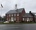
City hall
-

City Seal
-
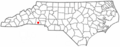
Location of Shelby, North Carolina
-
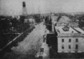
Shelby in 1925
See also
 In Spanish: Shelby (Carolina del Norte) para niños
