
Society Hill facts for kids
|
Society Hill Historic District
|
|
 Head House Square on the 400 block of S. 2nd Street
 Map of Center City Philadelphia with Society Hill outlined in red
|
|

Location in Philadelphia

Location in Pennsylvania

Location in the United States
|
|
| Location | Center City, bounded by 8th, Front, Walnut, and Lombard Streets |
|---|---|
| Area | 163 acres (66 ha) |
| Built | 18th-century and later |
| Architectural style | Georgian, Federal, Greek Revival |
| NRHP reference No. | 71000065 |
Quick facts for kids Significant dates |
|
| Added to NRHP | June 23, 1971 |
Society Hill is a very old and historic neighborhood in Center City, Philadelphia, Pennsylvania. In 2010, about 6,215 people lived there. It was settled in the early 1680s, making it one of Philadelphia's oldest places to live.
For a while, the neighborhood became run-down. But in the 1950s, a big project started to fix it up and save its many historic buildings. Now, Society Hill is one of the most expensive and desirable neighborhoods in Philadelphia. Its old colonial buildings and the efforts to restore them made the American Planning Association call it one of America's "great neighborhoods" in 2008. It's also seen as a good example of how cities can be improved in a lasting way.
Society Hill has one of the largest collections of original buildings from the 1700s and early 1800s in the United States. It's known for its special Franklin street lamps, brick sidewalks, and streets made of cobblestone or Belgian blocks. Most buildings are two- to four-story brick rowhouses built in the Federal and Georgian architecture styles. You can also find public buildings in the Greek Revival architecture style, like the Merchants' Exchange Building and the Old Pine Street Church.
Contents
What's in a Name?
Society Hill gets its name from a group called the Free Society of Traders. This group was formed in the 1600s. They had their offices on Front Street, on the hill above Dock Creek. The Free Society of Traders was made up of important merchants, landowners, and friends of William Penn. They were given special rights to help guide the economy of the new colony.
Society Hill was first known as the Dock Ward. This name made sense until after World War II, when the shipping business moved away. The Dock Ward was first set up in 1705. It was one of the ten original areas the city used to divide land east of 7th Street. In 1854, the Dock Ward was renamed the 5th Ward. The ward boundaries changed again in 1965, so the 5th Ward no longer matches Society Hill's borders.

Where is Society Hill?
Society Hill covers about 0.254 square miles (163 acres). It is located next to the Delaware River, just south of Old City and Independence Hall. The neighborhood is generally thought to be between Walnut, Lombard, Front, and 8th Streets.
The Society Hill Civic Association divides the area even further. They use Spruce Street and 4th Street to create four sections: northeast (NE), southeast (SE), southwest (SW), and northwest (NW). Sometimes, people describe the borders a little differently. For example, some say the eastern border goes all the way to the Delaware River.
A Look Back at Society Hill's History
Society Hill quickly became one of the busiest areas in colonial Philadelphia. This was because it had great access to the Delaware River and important city buildings like Independence Hall. Many market halls, taverns, and churches were built here. Wealthy Philadelphians also built their brick homes in this neighborhood.
After the American Revolutionary War, Dock Creek became very polluted. It was used as a public sewer. So, the city filled in the creek and created Dock Street. A new food market was built there. Philadelphia's streets were usually laid out in a grid pattern. But the new Dock Street curves between Chestnut and Spruce Streets, connecting 2nd and 3rd. This unusual shape is because it follows the path of the old creek.
In the 1800s, the city grew westward. Society Hill became less popular. Its houses started to fall apart. By the 1940s, Society Hill was a very poor neighborhood, one of the worst in the city.
In the 1950s, the city, state, and federal governments started a big project. It was one of the first programs aimed at saving historic buildings. Most commercial buildings from the 1800s were torn down. But important historic houses were either fixed up by their owners or bought by the Philadelphia Redevelopment Authority. These houses were then sold to people who promised to restore their outsides. To make the area feel more colonial, new 18th-century style street lights and brick sidewalks were added. Empty lots and torn-down buildings were replaced with parks, walkways, and modern townhouses.

From 1957 to 1959, several groups worked together to buy 31 acres around Dock Street. They tore down and moved the Dock Street market. Five acres of land were set aside for what would become the Society Hill Towers.
In 1957, Edmund Bacon, a key city planner, chose the Webb and Knapp company to redevelop Society Hill. Architect I. M. Pei and his team designed three tall 31-story Society Hill Towers and some shorter buildings. The Towers and townhouses were finished in 1964. The whole plan was completed in 1977. Architect Louis Sauer also designed many rowhouse projects nearby, like Waverly Court.
Many historic buildings stand in Society Hill today. The Society Hill Synagogue was built in 1829 as a Baptist church. It was designed by Philadelphia architect Thomas Ustick Walter, who also worked on the United States Capitol in Washington, D.C.. The synagogue was added to the National Register of Historic Places in 1971. Another important building is St. Peter's Church. It was built between 1758 and 1761 by Robert Smith. Congregation Kesher Israel uses and has updated a building built by the Universalist Church in 1796 at 412 Lombard Street.
The Society Hill Historic District was officially listed on the National Register of Historic Places in 1971. In 1999, it was also added to the Philadelphia Register of Historic Places.

People in Society Hill
| Historical population | ||
|---|---|---|
| Year | Pop. | ±% |
| 1860 | 24,792 | — |
| 1950 | 7,000 | −71.8% |
| 1970 | 4,841 | −30.8% |
| 1980 | 5,213 | +7.7% |
| 1990 | 5,715 | +9.6% |
| 2000 | 5,808 | +1.6% |
| 2010 | 6,215 | +7.0% |
| 2020 | 7,644 | +23.0% |
| Source: Encyclopedia of Greater Philadelphia for 1860 and 1950 populations. Center City District for populations from 1970-2010. 2020 population for Census tracts 10.01 (2,993) and 10.02 (4,651). | ||
In 2010, 6,215 people lived in Society Hill. This was about 0.4% of Philadelphia's total population. Society Hill is also much more crowded than the rest of Philadelphia. It has about 22,281 people per square mile, which is twice the city's average.
Schools in the Area
Public Schools
The School District of Philadelphia assigns students to public schools. Children living in Society Hill go to the General George A. McCall School for kindergarten through eighth grade. This school is located at 325 S. 7th Street. After McCall, students go to Benjamin Franklin High School.

The McCall School serves both Society Hill and the Chinatown areas. The school building was finished in February 1911. In 2004, McCall already had a good reputation for strong academics and safety. By 2009, it had improved even more. In 2012, it was called one of the "district's stronger neighborhood schools."
Private Schools
St. Peter's School is a private school located on Lombard Street. It teaches students from preschool (age 3) through eighth grade. The school was started in 1834.
St. Mary Interparochial Grade School is the designated Catholic school for Old St. Mary's Church and Old St. Joseph's Church.
Libraries
The Free Library of Philadelphia has its Independence Branch at 18 South 7th Street. The Athenaeum is a private library and museum. It has collections about architecture and interior design history.
Historic Churches and Synagogues

Society Hill has many important historic places of worship. They show how William Penn's idea of religious freedom worked out.
- Old St. Joseph's Church (1733)
- St. Peter's Church (1761)
- Old St. Mary's Church (1763)
- Old Pine Street Church (1768)
- Holy Trinity Church (1784)
- Mother Bethel A.M.E. Church (1794)
- Society Hill Synagogue (since 1967; was First Baptist from 1829–1909)
Getting Around Society Hill
Society Hill is easy to reach using different types of public transport.
Subway and Train
| Transportation network | |
|---|---|
| Lua error in Module:Location_map at line 420: attempt to index field 'wikibase' (a nil value). |
The Market–Frankford Line subway stops at 2nd Street and 5th Street. These stations are two blocks north of Society Hill's Walnut Street border.
The PATCO Speedline is a train system that connects Philadelphia and southern New Jersey. It stops at 8th and Market Street station, two blocks north of Society Hill. It also stops at the 9th and Locust Street station, which is one block west of Society Hill's 8th Street border.
Buses
Several SEPTA buses run through or near Society Hill.
- The 9 and 21 buses go west along Walnut Street.
- The 12 and 42 buses go west along parts of Spruce and Walnut Streets. The 12 also goes east along Pine Street.
- The 47 bus goes north along 7th Street and south along 8th Street.
- The 57 bus goes north along 3rd Street and south along 4th Street.
Biking
Since 2009, special bike lanes have been added. They run east along Pine Street and west along Spruce Street. Society Hill also has Indego bike-share stations. You can find them at 9th and Locust Streets, 4th and Walnut Streets, Dock and Front Streets, 2nd and Lombard Streets, and 6th and Locust Streets.
Greenways
Society Hill has special paths called greenways. These paths connect the neighborhood with historic areas to the north. They are designed for walking to keep people away from car traffic. These greenways were a big idea of Edmund Bacon. They include small parks and walking paths that weave between buildings. St. Joseph's Way, St. Peter's Way, and Lawrence Court Walk are examples of these greenways. They connect places like St. Peter's Church, Old Pine Church, and Three Bears Park. The greenways also feature public art. They help make the neighborhood easy to walk around.
Famous People from Society Hill
Many famous people have lived in Society Hill over the years. Here are a few:
- Lynne Abraham (born 1941)
- Richard Allen (1760-1831)
- Baruch Samuel Blumberg (Nobel Prize winner) (1925-2011)
- Richardson Dilworth (1898-1974)
- Terry Gross (born 1951)
- Alexander Hamilton (1757-1804)
- Thaddeus Kosciuszko (1746-1817)
- James Madison (1751-1836) and Dolley Madison (1768-1849)
- John Penn (1729-1795)
- Philip Syng Physick (1768-1837)
- Samuel Powel (1738-1793)
- Wendell Pritchett
- Thomas Sully (1783-1872)
- Chase Utley (born 1978), a famous baseball player
Places to See
Here are some of the most notable places to visit in Society Hill, also marked on the map:
- The St. James 700 Walnut St.
- Tomb of the Unknown Revolutionary War Soldier – Washington Square
- Athenaeum 219 S. 6th St.
- Contributionship 212 S. 4th St.
- Old St. Joseph's Church 321 Willings Alley
- Powel House 244 S. 3rd St.
- Society Hill Towers 200 Locust St.
- Korean War Memorial 109 Spruce St.
- Sully Residence 530 Spruce St.
- Society Hill Synagogue 418 Spruce St.
- St. Mary's Roman Catholic Church 252 S. Fourth St.
- Physick House 321 S. 4th St.
- Cassey House 243 Delancey St.
- Mother Bethel A.M.E. Church 419 S. 6th St.
- Cong. B'nai Abraham 523 Lombard St.
- Vilna Congregation 509 Pine St.
- Old Pine Street Church 412 Pine St.
- St. Peter's School 319 Lombard St.
- St. Peter's Episcopal Church 3rd and Pine St.
- Kosciuszko House 301 Pine St.
- Head House 400 block of S. 2nd St.
Just north of Society Hill, you can also find the Liberty Bell, Independence Hall, Carpenters' Hall, the First Bank of the United States, the Second Bank of the United States, the Merchants' Exchange Building, and the Museum of the American Revolution.
Society Hill in Movies
- In the movie National Treasure (2004), Nicolas Cage's character runs through the streets of Society Hill. He also runs through the graveyard of Old Pine Street Church and Headhouse Market.
- The movie The Sixth Sense (1999) was also filmed here.
Gallery
-
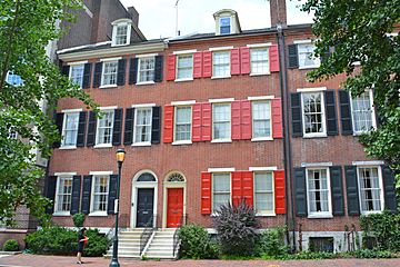
Townhouses near Washington Square
-
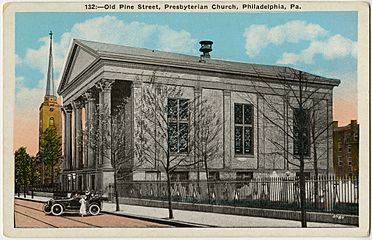
Old Pine Street Church


