
St Catherine's Hill, Dorset facts for kids
Quick facts for kids St Catherine's Hill |
|
|---|---|
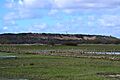
 St Catherine's Hill seen from the Avon Valley |
|

St Catherine's Hill
|
|
| OS grid reference | SZ 14441 95299 |
| District | |
| Shire county | |
| Region | |
| Country | England |
| Sovereign state | United Kingdom |
| Post town | Christchurch |
| Postcode district | BH23 |
| Police | Dorset |
| Fire | Dorset |
| Ambulance | South Western |
| EU Parliament | South West England |
St Catherine's Hill is a 53-metre (174 ft) hill in Christchurch. It stands tall between the Avon and Stour valleys. This hill, along with Ramsdown and Blackwater hills, forms a long ridge.
The hill is a very special place for nature. It is a Site of Special Scientific Interest (SSSI). Some parts are also Special Protection Areas (SPAs) or Special Areas of Conservation (SACs). This means they are protected because of their important plants and animals.
St Catherine's Hill has many different natural areas. You can find wet and dry heathland, forests with pine trees, and forests with leafy trees. It is home to rare animals like the sand lizard and smooth snake. You might also see the silver-studded blue butterfly. Even some meat-eating plants live here!
People have visited this hill for a very long time, since the Bronze Age. There are old monuments here. These include ancient burial mounds called tumuli. There is also a Roman signal station. People think there was an Iron Age animal pen too.
The military has used the hill for training for hundreds of years. Roman soldiers were here. Troops trained here during the Crimean War and both World Wars. During the Cold War, a nuclear bunker was built inside the hill. Today, most people visit the hill for fun. They walk their dogs, cycle, jog, or ride horses.
Contents
Why is it called St Catherine's Hill?
The hill gets its name from a chapel. This chapel was built for St Catherine. It used to stand on top of the hill. The chapel was connected to the Christchurch Priory nearby.
Old papers from the 1100s show the hill was once called Richedon. This name likely meant 'Great Hill'. It might have been compared to Littledown across the River Stour. In 1331, a new chapel for St Catherine was built on "Richesdon hill". People believe the hill got its new name soon after this.
Some old books have mixed up Richedon with another place called Rishton. Rishton was a farm by the little Moors River. It had a chapel for St Leonard. This led to a wrong idea that a St Leonard's chapel was on St Catherine's Hill. But this was a mistake.
Locally, the hill was also called Kattern's Hill. Some thought this name was older than the chapel and linked to Pagan gods. However, it is almost certain this name came from "Catherine". In other places, Kattern's Day was a celebration for St Catherine on November 25.
A Look Back in Time: History of the Hill
Scientists have found animal bones from before the ice age on the hill. The gravel covering the area was left by melting ice. So, some bones might have been washed there. Many Mesolithic and a few Paleolithic tools have been found here. There was even a place where people made flint tools nearby.
People from the Neolithic age used the nearby Stour valley. We don't have direct proof they visited the hill. But there are Bronze Age burial mounds on all three hills, including St Catherine's. Farmers lived in the valley below during the Neolithic and Bronze Ages. There is also an old fenced area on top of the hill. It is too small to be a fort. Experts think it was an Iron Age animal pen.

St Catherine's Hill was likely used as a lookout point. It has amazing views. Christchurch Harbour was a key trading port in the Iron Age and Roman times. The hill overlooks the Avon and Stour rivers. Both rivers could be used by boats until the 1700s.
Roman pottery pieces have been found in a ditch on the hill. This ditch seems to be part of a fort or signal station. It overlooked the main road from Christchurch to Wimborne. It also watched over an important river crossing on the Stour. With a simple wooden tower, soldiers could see the River Avon, the harbour, and Hengistbury Head.
The Chapel on the Hill
Later, a chapel was built inside the old Roman signal station. We don't know exactly when it was built. But a paper from 1331 says a chapel for St Catherine was "newly built". It seems the local Bishop, John de Stratford, didn't know about it. He stopped church services there until he could check it out. The next year, permission was given for weekly services. The chapel probably stopped being used after Christchurch Priory closed down in 1539. People then took away any useful building materials.
In 1921, people dug trenches at the chapel site. They found many pieces of stone and roof tiles. But they found no foundations. They decided a large building had been there. But all the good materials had been taken away. In 1967, more digging happened. They found an ichthys (a fish symbol) drawn on a stone. They also found pottery and colored glass. Finding two types of flooring and many building stones showed the chapel had stood for a long time. Some say the hill was first chosen for Christchurch Priory. But building materials were moved each night to the church's current spot.

Military Use of the Hill
During the Tudor period, the hill was a Coast Hill Beacon. This meant it had two fire baskets. These beacons might have been lit to warn of the approaching Spanish Armada. The hill was still used as a beacon during the Napoleonic Era. This was when people expected a French invasion.
The military has used the hill a lot for training. During the Crimean War, soldiers trained here. They practiced moving cannons on rough ground.
World War Training
In World War I, a full set of trenches was built on the hill. This included firing trenches, communication trenches, and observation posts. Soldiers trained here for trench warfare before going to Flanders. The area was also used in World War II. Tanks practiced driving here. Anti-aircraft guns were placed here to protect the aerodrome at Hurn.
After World War II, a nuclear bunker was built into the hill. It was for the Royal Observer Corps. A three-person team could live inside for up to three weeks. They would watch the effects of a nuclear blast. The bunker closed in 1991. Today, only a disused telegraph pole remains nearby.
Changes to the Hill
Sand and gravel have been dug from different parts of the hill. The whole of Toothill, on the east side, was removed. The hole left behind is now partly filled with water. Gravel digging continued until at least 1933. A local newspaper complained that an ancient burial mound was being sold off.
A water reservoir was first built on the hill in 1895. It was rebuilt in 1930. A second reservoir was added in 1960. These reservoirs provide Christchurch and West Hampshire with a lot of water. In the 1960s and 70s, most of the west side of the hill was used for building houses.
St Catherine's Hill Today
Today, the hill is mostly used for fun and learning. People enjoy walking, jogging, cycling, and horse riding. Dog walking is very popular here. About 70% of visitors come to walk their dogs. Even though it's not allowed, some people ride off-road quadbikes and motorcycles.
A local group called Amphibian and Reptile Conservation (ARC) manages an area of heathland. They also lead guided walks around the hill. On the south side, a local gun club practices target shooting in an old quarry.
Exploring the Geography of the Hill

St Catherine's Hill, Ramsdown, and Blackwater hills form a three-mile long ridge. This ridge runs north to south between the Avon and Stour valleys. It is just northwest of where the rivers meet in Christchurch. The top of this ridge is mostly flat. It is about 45 metres (148 ft) above sea-level at the south end and 49 metres (161 ft) in the north.
St Catherine's Hill is the highest point of these three hills. It is 53 metres (174 ft) high. It also has some very steep slopes. The 400-acre site has both woodland and heath. It is part of a larger Site of Special Scientific Interest (SSSI). The eastern slopes and foot of the hill are mostly open heath. This area is called the Town Common. It is also a Special Protection Area (SPA) and Special Area of Conservation (SAC).
How the Hill Was Formed
St Catherine's Hill was formed during the Eocene and Pleistocene eras. The hilltop is covered with river terrace gravels. These are mostly flints and coarse sands. Below them are finer Branksome Sands, then Parkstone Clay, and the Poole Formation. You can see some of these layers in the old quarries.
Scientists believe some layers were laid down by rivers or estuaries. If true, these are the only known sediments of this age in Southern England formed this way. They show an Eocene shoreline between Christchurch and Hengistbury Head. These layers make the site important for geology, earning it SSSI status.

Plants and Animals of St Catherine's Hill
The soils on the hill are acidic and don't have many nutrients. These soils support many different habitats. You can find wet and dry heathland, as well as forests with different types of trees.
Dry heath is mostly on top of the hill. It drains well and is made up of heather and small shrubs. There are also bare sandy spots where the rare Mossy Stonecrop (Crassula tillaea) grows. All six native types of reptiles live and breed here. This includes the endangered sand lizard (Lacerta agilis) and smooth snake (Coronella austriaca).
The smooth snake also lives in the wet heath areas. These are mostly at the foot of the hill. They are created by water seeping from below the hill. Rare plants here include bog asphodel (Narthecium ossifragum), hare's-tail cotton-grass (Eriophorum vaginatum), and bog moss (Sphagnum). You can also find carnivorous sundews (Drosera intermedia and Drosera rotundifolia) and pale butterwort (Pinguicula lusitanica).

Pine trees like maritime and Scots pine cover the top and western slopes. Leafy trees are mostly on the south and west sides, and lower east side. These include grey willow, downy birch, and sometimes aspen in wet spots. Some of these trees, especially the pines, have spread too much. So, there's a plan to remove some of them.
The mix of forests and heath on the hill provides homes for many important birds. Birds of prey like the hobby (Falco subbuteo), buzzard (Buteo buteo), hen harrier (Circus cyaneus), and merlin (Falco columbarius) live here. Forest birds like the song thrush (Turdus philomelos), crossbill (Loxia curvirostra), green (Picus viridus), and great spotted woodpecker (Dendrocopos major) are also found. Many of these birds are decreasing in numbers. Wetland birds like snipe and the red shank (Tringa totanus) also use the area. Many birds breed here, including the rare Dartford warbler (Sylvia undata), woodcock (Scolopax rusticola), and nightjar (Caprimulgus europaeus).
Some rare insects live on the hill too. The scarce chaser (Libellula fulva), hairy dragonfly (Brachytron pratense), and downy emerald (Cordulia aenea) use the ponds in the wet heath. The heath grasshopper (Chorthippus vagansand) and the silver-studded blue butterfly (Plebejus argus) can be found in the sandy heather areas.
Images for kids
-
St Catherine's Hill seen from the Avon Valley
