
Saint Helena facts for kids
Quick facts for kids
Saint Helena
|
|||
|---|---|---|---|
|
Overseas territory of the UK
|
|||

Jamestown, capital of Saint Helena
|
|||
|
|||
| Motto(s):
"Loyal and Unshakeable"
|
|||
| Anthem: My Saint Helena Island (unofficial) | |||

Location of Saint Helena in the Atlantic Ocean.
|
|||
| Country | |||
| Overseas territory | Saint Helena, Ascension and Tristan da Cunha | ||
| Island | Saint Helena | ||
| Capital | Jamestown | ||
| Discovered | 1502 | ||
| Current constitution | 2009 | ||
| Named for | Helena of Constantinople | ||
| Government | |||
| • Type | Monarchy | ||
| Area | |||
| • Total | 122 km2 (47 sq mi) | ||
| Highest elevation | 818 m (2,684 ft) | ||
| Lowest elevation | 0 m (0 ft) | ||
| Population
(2008)
|
|||
| • Total | 4,255 | ||
| • Density | 34.88/km2 (90.3/sq mi) | ||
| Demonym(s) | Saint Helenian | ||
| Time zone | UTC+0 (GMT) | ||
| Area code(s) | +290 | ||
| Internet TLD | .sh | ||
| Currency | Saint Helena pound (SHP) | ||
| Website | www.sainthelena.gov.sh | ||


Saint Helena is an island in the South Atlantic Ocean. It was formed by volcanoes. The island is named after Saint Helena of Constantinople.
Saint Helena is part of a larger group called the British Overseas Territory of Saint Helena, Ascension and Tristan da Cunha. This group also includes Ascension Island and the islands of Tristan da Cunha.
The island of Saint Helena is about 16 kilometers (10 miles) long and 8 kilometers (5 miles) wide. In 2008, about 4,084 people lived there.
A famous person, Napoleon Bonaparte, was sent to this island by the British. This happened after he returned from Elba island and lost the Battle of Waterloo. Napoleon died on Saint Helena in 1821.
The island is being considered as a UNESCO World Heritage Site. This means it could be recognized for its special global importance.
Contents
Island History: How Saint Helena Was Found
Early Discoveries (1502–1658)
The island was found in 1502 by a Portuguese admiral named João da Nova. He named it "Santa Helena" after Helena of Constantinople. For a long time, people thought it was discovered on May 21. However, new research suggests May 3 is more likely.
Another idea is that the island De Nova found was actually Tristan da Cunha, which is 2,430 kilometers (1,510 miles) south. This theory suggests Saint Helena was discovered by ships led by Estêvão da Gama on July 30, 1503.
When the Portuguese arrived, no one lived on the island. It had many trees and fresh water. They brought livestock, fruit trees, and vegetables. They also built a small chapel and a few houses.
The Portuguese did not create a lasting settlement. But the island became an important stop for ships traveling from Asia to Europe. Sailors could get food and water there. Sick sailors were often left on the island to get better. After 1588, Dutch and English ships also started visiting.
The Dutch Republic officially claimed Saint Helena in 1633. But there is no proof they ever lived there or built defenses. By 1651, the Dutch had mostly left the island. They preferred their colony at the Cape of Good Hope.
East India Company Takes Over (1658–1815)

In 1657, the English East India Company received permission from Oliver Cromwell to govern Saint Helena. The next year, the Company decided to start a colony there with farmers.
The first governor, Captain John Dutton, arrived in 1659. This made Saint Helena one of Britain's oldest colonies outside North America and the Caribbean. A fort was built, along with several houses.
After the English monarchy was restored in 1660, the East India Company got a Royal permit to continue their colony. The fort was named James Fort and the town Jamestown. These names honored the Duke of York, who later became King James II of England.
Bringing slaves to the island became illegal in 1792. Instead, Chinese workers were brought in to work on the farms. Many of them were allowed to stay. Their families became part of the island's population.
Napoleon's Exile and British Rule (1815–1821)

In 1815, the British government decided to use Saint Helena as a prison for Napoleon Bonaparte. To stop him from escaping to nearby islands, they officially took control of Ascension and Tristan da Cunha. Napoleon died on Saint Helena in 1821.
In 1858, the French emperor Napoleon III bought Longwood House and the land around it for the French government. This was the last home of Napoleon I. It is still owned by France today.
Becoming a Crown Colony (1834–1981)
On April 22, 1834, Saint Helena officially became a Crown colony of the British. This meant it was directly controlled by the British government.
A local business making fibre from New Zealand flax started again in 1907. It made a lot of money during the First World War. However, this industry later struggled because of high shipping costs and competition from new man-made fibers. The last flax factory closed in 1965.
In 1922, Ascension Island became a dependency of Saint Helena. Then, Tristan da Cunha Island joined on January 12, 1938.
Saint Helena Today (1981 to Present)

In 1981, the British government changed the status of Saint Helena and other Crown colonies. They were renamed "British Dependent Territories."
In 2009, Saint Helena and its two territories (Ascension and Tristan da Cunha) were given equal status. A new constitution was created. The British Overseas Territory was then renamed Saint Helena, Ascension and Tristan da Cunha.
Geography and Wildlife: Exploring the Island

The island of Saint Helena covers a total area of 122 square kilometers (47 square miles). The middle of the island has forests, some of which were planted by people.
Much of the island is important for protecting birds. This is especially true for the Saint Helena Plover, also known as the Wirebird. This bird lives only on Saint Helena. The island is also important for seabirds that nest on the small islets near the coast.
The highest point on the island is Diana's Peak. It is 818 meters (2,684 feet) tall. In 1996, it became the island's first national park. In 2000, a project began to replant a lost forest called the Great Wood. This new forest is called the Millennium Forest. It is now managed by the Saint Helena National Trust, which started in 2002.
There are several rocks and small islands off the coast. These include Castle Rock, Speery Island, and Bird Island. All of them are within one kilometer (0.6 miles) of the shore.
The national bird of Saint Helena is the Saint Helena Plover, or Wirebird. You can see it on the coat of arms of Saint Helena and on the flag.
Climate: What's the Weather Like?
Saint Helena has a tropical climate. This means it is warm all year round. The weather is mild because of the trade winds that blow almost all the time.
Island Districts: How Saint Helena is Divided
Saint Helena is divided into eight districts. People who work and live in the Jamestown Harbour and on the Royal Mail Ship St. Helena (RMS) are counted in the census where they work.
|

Economy: How People Make a Living
Until 1966, the island's economy relied on just one crop. This was New Zealand flax, used to make rope and string. Today, Saint Helena's economy is not very strong. It mostly depends on help from the British government.
Tourism on the island is very important. Many visitors come because of Napoleon's time there.
Saint Helena also makes coffee. It is said to be the most expensive coffee in the world. The island also produces and sells "Tungi Spirit." This drink is made from the fruit of the prickly pear cactus, called Opuntia ficus-indica. "Tungi" is the local name for this plant.
Ascension Island, Tristan da Cunha, and Saint Helena all print their own postage stamps. Selling these stamps brings in a good amount of money.
Money Matters: Banking and Currency
Saint Helena has its own money, called the Saint Helena pound. It has the same value as the pound sterling (British pound). The government of Saint Helena makes its own coins and banknotes.
The Bank of Saint Helena was started in 2004. It has branches in Jamestown on Saint Helena and in Georgetown on Ascension Island.
Related pages
Images for kids
-

Portuguese Viceroy Francisco de Almeida passed the island in 1505 but could not land. Other Portuguese explorers who landed at an earlier date include João da Nova in 1502 and Estêvão da Gama in 1503.
-
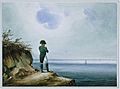
Napoléon à Sainte-Hélène by François-Joseph Sandmann
-
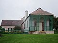
Longwood House in September 2014
-
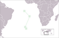
Positions (north to south) of Ascension Island, Saint Helena, and Tristan da Cunha in the South Atlantic Ocean
-
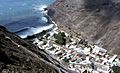
Jamestown, from above
-
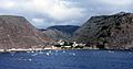
Jamestown, the capital of Saint Helena
-
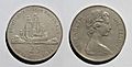
1673–1973 tercentenary 25-pence copper-nickel coin of St. Helena
-
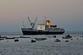
RMS St Helena in James Bay
-
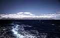
Looking back at the island from the RMS St Helena
-
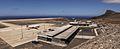
Saint Helena Airport in 2016
-

The football team before a game in Anglesey
_-_Autor_desconhecido_(cropped2).png)

.jpg)


See also
 In Spanish: Isla Santa Elena para niños
