
List of World Heritage Sites in the United Kingdom facts for kids
The United Nations Educational, Scientific and Cultural Organization (UNESCO) helps protect important places around the world. These places are called World Heritage Sites. They can be special because of their history, culture, or amazing natural beauty. UNESCO started this program in 1972 to make sure these sites are looked after for everyone.
The United Kingdom and its British Overseas Territories have 33 UNESCO World Heritage Sites. Some are in England, others in Scotland, Wales, and Northern Ireland. There are also sites in places like Bermuda, Gibraltar, and the Pitcairn Islands.
The first UK sites added to the list in 1986 included the amazing Giant's Causeway in Northern Ireland, Durham Castle and Durham Cathedral, and the ancient Stonehenge, Avebury and Associated Sites. More recently, in 2021, The Slate Landscape of Northwest Wales and the city of Bath (as part of the Great Spas of Europe) were added.
UNESCO was officially formed in 1946 by 26 countries, including the UK. Its main goal is to protect the world's important books, artworks, and historical places. The UK government works with the UK National Commission for UNESCO to help manage these special sites.
World Heritage Sites are chosen based on different reasons. Some are picked for their cultural importance, like ancient buildings or historical towns. Others are chosen for their natural beauty, like unique landscapes or places with rare animals and plants. A few sites are "mixed," meaning they are important for both cultural and natural reasons. For example, St Kilda in Scotland is a mixed site. It's special for its natural habitats and the unique way people used to live there.
Sadly, one site, Liverpool Maritime Mercantile City, was removed from the list in 2021. This happened because new building projects changed the area too much, affecting its special historical value.
Contents
Where are the Sites Located?
The UK's World Heritage Sites are spread out across the country and its overseas territories. One site, the Frontiers of the Roman Empire, is found in both England and Scotland (and also in Germany!). Most sites are in England, but Scotland, Wales, and Northern Ireland also have many. You can also find sites in places like Bermuda, Gibraltar, the Pitcairn Islands, and Tristan da Cunha.
The maps below show where all these amazing places are located.
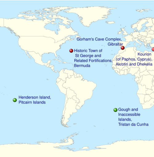
The World Heritage Sites of the UK (Overseas Territories): The natural sites of Gough and Inaccessible Islands and Henderson Island are marked green, the cultural sites of the Historic Town of St George and Related Fortifications, Kourion, and Gorham's Cave are marked red.
|
List of UK World Heritage Sites
Here is a list of the World Heritage Sites in the United Kingdom and its territories. Each entry tells you a bit about the site, where it is, and why it's important.
| Name | Image | Location | Country/territory | Coords | Date | UNESCO data | Description |
|---|---|---|---|---|---|---|---|
| Blaenavon Industrial Landscape |  |
Blaenavon, |
Wales | 51°47′N 3°05′W / 51.78°N 3.08°W | 19th century | 984; 2000; iii, iv |
In the 1800s, Wales was a world leader in making iron and mining coal. Blaenavon shows what the landscape looked like because of these industries. The site includes old quarries, buildings, workers' homes, and a railway. |
| Blenheim Palace |  |
Woodstock, Oxfordshire, |
England | 51°50′28″N 1°21′40″W / 51.841°N 1.361°W | 1705–1722 | 425; 1987; ii, iv |
Blenheim Palace was the home of John Churchill, 1st Duke of Marlborough. It was designed by famous architects and its park was shaped by Capability Brown. The palace celebrates a victory over France and helped create a unique English style of architecture. |
| Canterbury Cathedral, St Augustine's Abbey, and St Martin's Church |  |
Canterbury, Kent, |
England | 51°17′N 1°05′E / 51.28°N 1.08°E | 11th century | 496; 1988; i, ii, vi |
St Martin's Church is the oldest church in England. This church and St Augustine's Abbey were important when Christianity first came to the Anglo-Saxons. Canterbury Cathedral shows beautiful Romanesque and Gothic architecture styles. It is also the main church of the Church of England. |
| Castles and Town Walls of King Edward in Gwynedd |  |
Conwy, Isle of Anglesey and Gwynedd, |
Wales | 53°08′20″N 4°16′34″W / 53.139°N 4.276°W | 13th–14th centuries | 374; 1986; i, iii, iv |
During the time of Edward I of England, many castles were built in Wales. These castles, like Beaumaris, Caernarfon, Conwy, and Harlech, were meant to control the area. They are seen as some of the best examples of military architecture from that time. |
| City of Bath |  |
Bath, Somerset, |
England | 51°22′48″N 2°21′36″W / 51.380°N 2.360°W | 1st–19th centuries | 428; 1987; i, ii, iv |
The Romans founded Bath as a spa town. It was also important for the wool industry in the Middle Ages. Later, in the 1700s, it became a popular spa resort. The city is famous for its Roman ruins and beautiful Palladian architecture. |
| Cornwall and West Devon Mining Landscape |  |
Cornwall and Devon, |
England | 50°08′N 5°23′W / 50.13°N 5.38°W | 18th and 19th centuries | 1215; 2006; ii, iii, iv |
In the 1700s and 1800s, tin and copper mining was huge in Cornwall and Devon. At one point, this area produced two-thirds of the world's copper! The mining methods and technology developed here were used all over the globe. |
| Derwent Valley Mills |  |
Derwent Valley, Derbyshire, |
England | 53°01′12″N 1°29′56″W / 53.020°N 1.499°W | 18th and 19th centuries | 1030; 2001; ii, iv |
The Derwent Valley Mills is where the factory system began. New ideas here, like workers' housing and machines such as the water frame, were very important for the Industrial Revolution. The changes made in Derwent Valley influenced factories across North America and Europe. |
| Dorset and East Devon Coast |  |
Dorset and Devon, |
England | 50°42′N 2°59′W / 50.70°N 2.98°W | 1029; 2001; viii |
The cliffs along the Dorset and Devon coast are a fantastic place to find fossils. They show a continuous record of life on land and in the sea from 185 million years ago! | |
| Durham Castle and Cathedral |  |
Durham, County Durham, |
England | 54°46′26″N 1°34′30″W / 54.774°N 1.575°W | 11th and 12th centuries | 370; 1986; ii, iv, vi |
Durham Cathedral is a stunning example of Norman architecture in England. Its unique vaulting helped lead to the Gothic architecture style. The cathedral holds important relics of St Cuthbert and Bede. The Norman castle was home to the powerful Durham prince-bishops. |
| The English Lake District |  |
Cumbria, |
England | 54°28′26″N 3°4′56″W / 54.47389°N 3.08222°W | 422; 2017; ii, v, vi |
The Lake District is famous for its beautiful mountains, lakes, houses, gardens, and parks. Artists and writers have celebrated its scenic views since the 1700s. | |
| Forth Bridge | .jpg) |
Edinburgh, Inchgarvie and Fife, |
Scotland | 56°00′02″N 3°23′19″W / 56.000421°N 3.388726°W | 1890 | 1485; 2015; i, iv |
The Forth Bridge is a huge cantilever railway bridge over the Firth of Forth in eastern Scotland. It's a well-known symbol of Scotland. English engineers Sir John Fowler and Sir Benjamin Baker designed it, and Sir William Arrol built it. |
| Frontiers of the Roman Empire |  |
Northern |
England, Scotland | 54°59′N 2°36′W / 54.99°N 2.60°W | 2nd century | 430; 1987 (modified in 2005 and 2008); ii, iii, iv |
Hadrian's Wall was built in 122 AD, and the Antonine Wall in 142 AD. These walls were built to protect the Roman Empire from invaders. This World Heritage Site now includes both walls in the UK, as well as Roman barriers and forts in modern Germany. |
| Giant's Causeway and Causeway Coast |  |
County Antrim, Northern Ireland |
Northern Ireland | 55°14′24″N 6°30′40″W / 55.240°N 6.511°W | 60–50 million years ago | 369; 1986; vii, viii |
The Giant's Causeway has 40,000 basalt columns that stick out of the sea. They were formed by volcanoes millions of years ago. This amazing natural wonder has inspired many legends and has been important for studying the Earth for centuries. |
| Gorham's Cave Complex |  |
East face of the Rock of Gibraltar, |
Gibraltar | 36°07′13″N 5°20′31″W / 36.120397°N 5.342075°W | 33-23 thousand years ago | 1500; 2016; iii |
This complex has four natural sea caves. It's known as the last place where Neanderthals lived about 28,000 years ago. There is also evidence that modern humans lived here. |
| Gough and Inaccessible Islands |  |
Saint Helena, Ascension and Tristan da Cunha | 40°19′05″S 9°56′07″W / 40.3181°S 9.9353°W | 740; 1995 (modified in 2004); vii, x |
The Gough and Inaccessible Islands are home to an ecosystem that has been almost untouched by humans. They have many unique kinds of plants and animals found nowhere else. | ||
| Great Spas of Europe |  |
Bath, Somerset, (Transnational property) |
England | 1st–20th centuries | 1613; 2021; ii, iii |
The city of Bath is one of the "Great Spa Towns of Europe." This is a World Heritage Site that includes several towns famous for their natural baths and spa traditions. | |
| Heart of Neolithic Orkney |  |
Orkney, |
Scotland | 58°59′46″N 3°11′17″W / 58.996°N 3.188°W | 3rd millennium BC | 514; 1999; i, ii, iii, iv |
This site is a collection of ancient Neolithic places in Orkney. They include the village of Skara Brae, the tomb of Maes Howe, and the stone circles of Stenness and Brodgar. These sites were used for living and for ceremonies thousands of years ago. |
| Henderson Island |  |
Henderson Island, |
Pitcairn Islands | 24°21′S 128°19′W / 24.35°S 128.31°W | n/a | 487; 1988; vii, x |
This island is an atoll in the South Pacific Ocean. Its environment has been almost untouched by humans. Its isolation helps us understand how evolution works. There are ten plant and four animal species found only on this island. |
| Historic Town of St George and Related Fortifications, Bermuda |  |
St George, |
Bermuda | 32°22′46″N 64°40′40″W / 32.379444°N 64.677778°W | 17th–20th centuries | 983; 2000; iv |
Founded in 1612, St George's is the oldest English town in the "New World." It's a great example of how towns were planned by colonial powers in the 1600s. The fortifications show how defenses changed from the 17th to the 20th centuries. |
| Ironbridge Gorge |  |
Ironbridge, Shropshire, |
England | 52°37′34″N 2°29′10″W / 52.626°N 2.486°W | 18th century | 371; 1986; i, ii, iv, vi |
Ironbridge Gorge has old mines, factories, workers' homes, and transport systems from the Industrial Revolution. The development of coke production here helped kickstart the Industrial Revolution. The Iron Bridge was the world's first bridge made of iron and was very important for engineering. |
| Jodrell Bank Observatory |  |
Cheshire, |
England | 53°14.5′N 2°18.7′W / 53.2417°N 2.3117°W | 1945 | 1594; 2019; i, ii, iv, vi |
Located in a quiet part of northwest England, Jodrell Bank is one of the world's top radio astronomy observatories. It started in 1945 by studying cosmic rays. This observatory, still working today, has several radio telescopes and buildings. Jodrell Bank has made a huge scientific impact, helping us understand meteors, the moon, and even tracking spacecraft. It shows how astronomy changed from using optical telescopes to radio telescopes, which completely changed our view of the universe. |
| Maritime Greenwich |  |
Greenwich, London, Greater London, |
England | 51°28′45″N 0°00′00″E / 51.4791°N 0°E | 17th and 18th centuries | 795; 1997; i, ii, iv, vi |
This area has the first example of Palladian architecture in England, and works by famous architects like Christopher Wren and Inigo Jones. It's also important for the Royal Observatory, where people learned a lot about astronomy and how to navigate ships. |
| New Lanark |  |
New Lanark, South Lanarkshire, |
Scotland | 55°40′N 3°47′W / 55.66°N 3.78°W | 19th century | 429; 2001; ii, iv, vi |
Inspired by the factory system in the Derwent Valley, New Lanark was built as a community for mill workers. A kind leader named Robert Owen bought the site and made it a model community. He provided public facilities, education, and supported better factory conditions. |
| Old and New Towns of Edinburgh |  |
Edinburgh, |
Scotland | 55°56′49″N 3°11′28″W / 55.947°N 3.191°W | 11th–19th centuries | 728; 1995; ii, iv |
Edinburgh's Old Town started in the Middle Ages, while the New Town was built much later, from 1767 to 1890. This shows the difference between medieval and modern city planning. The New Town's design influenced city planning across Europe in the 1700s and 1800s. |
| Palace of Westminster and Westminster Abbey including Saint Margaret's Church |  |
Westminster, Greater London, |
England | 51°29′59″N 0°07′43″W / 51.4997°N 0.1286°W | 10th, 11th, and 19th centuries | 426; 1987 (modified in 2008); i, ii, iv |
This site has been important for governing England (and later the UK) since the 1000s. All English and British kings and queens have been crowned at Westminster Abbey since William the Conqueror. The Palace of Westminster, where the British Parliament meets, is a great example of Gothic Revival architecture. St Margaret's Church is also part of this historic site. |
| Pontcysyllte Aqueduct and Canal |  |
Trevor, Wrexham, |
England | 52°58′12″N 3°05′13″W / 52.970°N 3.087°W | 1795–1805 | 1303; 2009; i, ii, iv |
This amazing aqueduct was built to carry the Ellesmere Canal over the Dee Valley. Designed by Scottish Engineer Thomas Telford during the Industrial Revolution, it used new ways of working with cast and wrought iron. It influenced civil engineering all over the world. |
| Royal Botanic Gardens, Kew |  |
Kew, Greater London, |
England | 51°28′26″N 0°17′42″W / 51.474°N 0.295°W | 18th–20th centuries | 1084; 2003; ii, iii, iv |
Created in 1759, the famous Kew Gardens were designed by important landscape architects. These gardens were used to study plants and ecosystems, helping us understand more about nature. |
| St Kilda |  |
St Kilda, |
Scotland | 57°48′58″N 8°34′59″W / 57.816°N 8.583°W | n/a | 387; 1987 (modified in 2005 and 2008); iii, v, vii, ix, x |
The isolated islands of St Kilda were lived on for over 2,000 years, but no one has lived there permanently since 1930. The islands have unique old buildings and are a breeding ground for many important seabirds, including the world's largest colony of gannets and many puffins. |
| Saltaire |  |
Saltaire, Shipley, West Yorkshire, |
England | 53°50′13″N 1°47′24″W / 53.837°N 1.790°W | 1853 | 1028; 2001; ii, iv |
Saltaire was built by mill-owner Titus Salt as a model village for his workers. The site, which includes the Salts Mill, had public buildings for the residents and was an example of how some factory owners cared for their workers in the 1800s. |
| The Slate Landscape of Northwest Wales |  |
Gwynedd, |
Wales | 18th–20th centuries | 1633; 2021; ii, v |
This site includes six key areas in Gwynedd, Wales, that were important for slate mining. These include places like Penrhyn Slate Quarry, Dinorwig Slate Quarry, and the Ffestiniog Railway. This landscape shows how the slate industry shaped the area from the 1700s to the 1900s. | |
| Stonehenge, Avebury and Associated Sites |  |
Wiltshire, |
England | 51°10′44″N 1°49′31″W / 51.1788°N 1.8252°W | 4th–2nd millennia BC | 373; 1986 (modified in 2008); i, ii, iii |
The ancient Neolithic sites of Avebury and Stonehenge are two of the biggest and most famous stone monuments in the world. They show how early humans interacted with their environment. People still wonder what these stone circles were used for, perhaps ceremonies or studying the stars. Other nearby sites like Silbury Hill are also included. |
| Studley Royal Park including the Ruins of Fountains Abbey |  |
North Yorkshire, |
England | 54°06′58″N 1°34′23″W / 54.116°N 1.573°W | 1132 (abbey), 19th century (park) |
372; 1986; i, iv |
Before the monasteries were closed in the 1500s, Fountains Abbey was one of the largest and richest Cistercian abbeys in Britain. It's one of the few that still stands from the 1100s. The later garden, which includes the abbey, still looks much like its original design and influenced garden design across Europe. |
| Tower of London |  |
Tower Hamlets, Greater London, |
England | 51°30′29″N 0°04′34″W / 51.5080°N 0.0761°W | 11th century | 488; 1988; ii, iv |
Started by William the Conqueror in 1066, the Tower of London is a symbol of power. It's a great example of Norman military architecture that spread throughout England. Later additions in the 1200s made it one of the most important castles of its kind. |
Sites Not Part of the UK List
There is one World Heritage Site in the Sovereign Base Areas of Akrotiri and Dhekelia that is considered part of Cyprus's list. This is because a treaty from 1960 states that Cyprus will manage and maintain its ancient monuments.
| Site | Image | Location | Criteria | Area ha (acre) |
Year | Description | Refs |
|---|---|---|---|---|---|---|---|
| Paphos (Kourion portion) |  |
Episkopi Cantonment, Episkopi, Limassol, |
Cultural: (iii)(vi) |
N/A | 1980 |
Future World Heritage Sites: The Tentative List
The Tentative List is like a waiting list for places that a country thinks might become World Heritage Sites in the future. Countries can add or remove sites from this list at any time. A place must be on this list for five to ten years before it can be officially considered by UNESCO.
The UK's Tentative List was last updated in July 2014. Some sites from that list have since become official World Heritage Sites. Here are some of the places still on the Tentative List in 2022:
| Name | Image | Location | Date | UNESCO data |
|---|---|---|---|---|
| Chatham Dockyard and its Defences |  |
Kent, 51°39′47″N 0°53′40″E / 51.66306°N 0.89444°E |
17th–19th centuries | 5670; 2012; ii, iv |
| Creswell Crags |  |
Derbyshire, 53°16′N 1°12′W / 53.26°N 1.20°W |
60–15 thousand years ago | 5671; 2012; iii |
| Darwin's Landscape Laboratory |  |
Greater London, 51°19′50″N 0°03′04″E / 51.33056°N 0.05111°E |
1842–1882 | 5672; 2012; iii, vi |
| Island of St Helena |  |
16°0′0″N 5°45′0″W / 16.00000°N 5.75000°W |
N/A | 5675; 2012; x |
| Mousa, Old Scatness and Jarlshof: the Zenith of Iron Age Shetland |  |
Shetland, |
4,000 years ago | 5677; 2012; iii, iv |
| Flow Country |  |
Caithness and Sutherland, 58°20′53″N 3°59′0″W / 58.34806°N 3.98333°W |
N/A | 5679; 2012; ix, x |
| The Twin Monastery of Wearmouth Jarrow |  |
Tyne and Wear, |
672/3 (Wearmouth) 681 (Jarrow) |
5681; 2012; ii, iii, iv, vi |
| Turks and Caicos Islands |  |
21°20′N 71°10′W / 21.333°N 71.167°W |
N/A | 5682; 2012; x |
In April 2023, the UK announced an updated Tentative List with 5 new sites. These sites will be further developed before being submitted to UNESCO for review. The 7 sites on the updated list are:
- Birkenhead the People’s Park
- East Atlantic Flyway – England East Coast Wetlands
- The Flow Country
- Gracehill Moravian Church Settlements
- Little Cayman Marine Parks and Protected Area
- York
- The Zenith of Iron Age Shetland
Former UNESCO World Heritage Site
| Name | Image | Location | Date | UNESCO data | Description |
|---|---|---|---|---|---|
| Liverpool – Maritime Mercantile City |
 |
Liverpool, Merseyside, 53°24′N 2°59′W / 53.40°N 2.99°W |
18th and 19th centuries | 1150; 2004; ii, iii, iv |
In the 1700s and 1800s, Liverpool was one of the world's busiest ports. Its global connections helped support the British Empire. It was a major port involved in the slave trade until it was stopped in 1807. It was also a starting point for people moving to North America. The docks here had new ideas in building and managing ports. The site was put on a list of "endangered" sites in 2012 and then removed from the World Heritage List in 2021. This happened because new buildings in the area changed the special historical value of Liverpool's waterfront. |
Images for kids
-
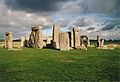
Stonehenge is part of the Stonehenge, Avebury and Associated Sites UNESCO World Heritage Site.
See also
 In Spanish: Anexo:Patrimonio de la Humanidad en el Reino Unido para niños
- List of World Heritage Sites in Europe
- List of World Heritage Sites in Scotland
- Lists of World Heritage Sites
- Tourism in the United Kingdom
