Summit County, Utah facts for kids
Quick facts for kids
Summit County
|
|
|---|---|

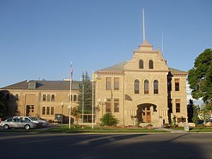
Summit County Courthouse in Coalville
|
|

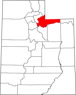
Location within the U.S. state of Utah
|
|
 Utah's location within the U.S. |
|
| Country | |
| State | |
| Founded | 1854 (created) 1861 (organized) |
| Named for | The summits of the mountains |
| Seat | Coalville |
| Largest city | Park City |
| Area | |
| • Total | 1,882 sq mi (4,870 km2) |
| • Land | 1,872 sq mi (4,850 km2) |
| • Water | 10 sq mi (30 km2) 0.5% |
| Population
(2020)
|
|
| • Total | 42,357 |
| • Estimate
(2023)
|
42,759 |
| • Density | 22.506/sq mi (8.6898/km2) |
| Time zone | UTC−7 (Mountain) |
| • Summer (DST) | UTC−6 (MDT) |
| Congressional district | 1st |
Summit County is a county located in the state of Utah, in the western United States. It's known for its rugged and mountainous land. As of 2020, about 42,357 people live there. The main town where the county government is located is Coalville. The biggest city in the county is Park City.
Contents
History of Summit County
Summit County was officially created by the Utah Territory government on January 13, 1854. At first, it wasn't fully set up and was managed by Great Salt Lake County. But by March 4, 1861, Summit County had its own government.
The county's borders changed a few times over the years. In 1868, when Wyoming Territory was formed, parts of Summit County became part of Wyoming. The last change to its borders happened on January 7, 1918. This was when Daggett County was created, taking some land from Summit County's eastern side. Since then, the county's shape has stayed the same.
Summit County got its name because it includes 39 of the highest mountain peaks in Utah! It's also very high up, with an average height of about 8,388 feet (2,557 meters) above sea level. This makes it one of the highest counties outside of Colorado. Because it's close to Salt Lake City, Park City has become a popular place for people to visit and live.
Summit County is part of a larger area called the Heber, UT Micropolitan Statistical Area. This area is also included in the bigger Salt Lake City-Provo-Orem, UT Combined Statistical Area.
Geography and Nature
Summit County is located on the upper east side of Utah. Its northeast border touches the southern and western borders of Wyoming. The central and eastern parts of the county are mostly covered by the Uinta Mountains, which run east to west. The western part of the county reaches the eastern slopes of the Wasatch Mountains, which run north to south.
The highest point in Summit County is Gilbert Peak. It sits on the border with Duchesne County and is about 13,448 feet (4,100 meters) above sea level. The county covers a total area of about 1,882 square miles (4,874 square kilometers). Most of this is land (1,872 square miles or 4,848 square kilometers), with a small amount of water (10 square miles or 26 square kilometers).

Main Roads
Many important roads run through Summit County. These include:
- Interstate 80
- Interstate 84
- U.S. Route 40
- U.S. Route 189
- Utah State Route 32
- Utah State Route 150
- Utah State Route 224
- Utah State Route 248
Neighboring Counties
Summit County shares borders with several other counties:
- Rich County (north)
- Uinta County, Wyoming (northeast)
- Sweetwater County, Wyoming (northeast)
- Daggett County (east)
- Duchesne County (southeast)
- Wasatch County (south)
- Salt Lake County (southwest and west)
- Morgan County (northwest)
Protected Natural Areas
Summit County is home to parts of several protected natural areas, including:
- Ashley National Forest
- Henefer-Echo Wildlife Management Area
- Rockport State Park
- Wasatch National Forest
Lakes and Reservoirs
Summit County has many lakes and reservoirs, which are important for water and recreation. Some of these include:
- Amethyst Lake
- Crystal Lake
- Echo Reservoir
- Gilbert Lake
- Hayden Lake
- Island Lake
- Jean Lake
- Lake Marion
- Ruth Lake
- Smith and Morehouse Reservoir
- Trial Lake
- Washington Lake
- Whitney Reservoir
People and Population
| Historical population | |||
|---|---|---|---|
| Census | Pop. | %± | |
| 1860 | 198 | — | |
| 1870 | 2,512 | 1,168.7% | |
| 1880 | 4,921 | 95.9% | |
| 1890 | 7,733 | 57.1% | |
| 1900 | 9,439 | 22.1% | |
| 1910 | 8,200 | −13.1% | |
| 1920 | 7,862 | −4.1% | |
| 1930 | 9,527 | 21.2% | |
| 1940 | 8,714 | −8.5% | |
| 1950 | 6,745 | −22.6% | |
| 1960 | 5,673 | −15.9% | |
| 1970 | 5,879 | 3.6% | |
| 1980 | 10,198 | 73.5% | |
| 1990 | 15,518 | 52.2% | |
| 2000 | 29,736 | 91.6% | |
| 2010 | 36,324 | 22.2% | |
| 2020 | 42,357 | 16.6% | |
| US Decennial Census 1790–1960 1900–1990 1990–2000 2010 2020 |
|||
According to the 2020 United States census, there were 42,357 people living in Summit County. The population density was about 22.6 people per square mile.
Most people in Summit County are White (about 82.9%). Other groups include Asian (1.7%), African American (0.4%), Native American (0.2%), and Pacific Islander (0.1%). About 11.2% of the population is Hispanic or Latino.
The population is fairly balanced between males (50.94%) and females (49.06%). About 24.4% of the people are under 18 years old, and 13.8% are 65 or older. The average age in the county is 40.8 years.
There are about 15,688 households in Summit County. Most of these (72.8%) are families. The average household size is 2.70 people. Many households (34.6%) have children under 18. Most homes (77.7%) are owned by the people living in them.
The average income for a household in Summit County was $106,973. For families, the average income was $119,592. About 4.5% of the population lives below the poverty line.
When it comes to education, most adults in Summit County have at least a high school diploma. Many have gone to college, with a large number earning a bachelor's degree (35.2%) or a graduate degree (20.9%).
Religion in Summit County
Summit County is more religiously diverse than many other parts of Utah. About 44.2% of the people say they don't belong to any religion. About 36.8% are members of the Church of Jesus Christ of Latter-day Saints (LDS Church). This is lower than the statewide average for Utah. About 10.6% of the population is Catholic.
Communities in Summit County
Summit County has several cities, towns, and other communities.
Cities
Towns
Census-Designated Places (CDPs)
These are areas identified by the U.S. Census Bureau for statistical purposes.
- East Basin
- Echo
- Hoytsville
- Marion
- Peoa
- Samak
- Silver Summit
- Snyderville
- Summit Park
- Wanship
- Woodland
Unincorporated Communities
These are places that are not part of an official city or town.
- Alpine Acres
- Bountiful Peak Summer Home Area
- Castle Rock
- Christmas Meadows Summer Home Area
- Emory
- Grass Creek
- Holiday Park
- Monviso
- Rockport
- Uintalands
- Upton
- Weber Canyon
- West Hills
Former Communities
Some communities that once existed in Summit County are no longer populated. These include:
- Atkinson
- Blacks Fork
- Mill City
- Wahsatch
Education in Summit County
Summit County has three main school districts that serve its students:
- North Summit School District
- Park City School District
- South Summit School District
There is also a local campus of Utah State University located in Park City, offering higher education opportunities.
See also
 In Spanish: Condado de Summit (Utah) para niños
 | Sharif Bey |
 | Hale Woodruff |
 | Richmond Barthé |
 | Purvis Young |

