Union County, Indiana facts for kids
Quick facts for kids
Union County
|
|
|---|---|

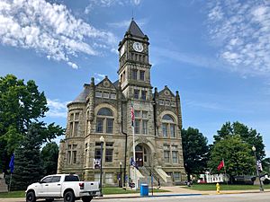
Union County Courthouse in Liberty
|
|

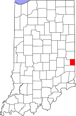
Location within the U.S. state of Indiana
|
|
 Indiana's location within the U.S. |
|
| Country | |
| State | |
| Founded | January 5, 1821 (created) February 1, 1821 (organized) |
| Seat | Liberty |
| Largest town | Liberty |
| Area | |
| • Total | 165.18 sq mi (427.8 km2) |
| • Land | 161.22 sq mi (417.6 km2) |
| • Water | 3.95 sq mi (10.2 km2) 2.39%% |
| Population
(2020)
|
|
| • Total | 7,087 |
| • Density | 43.6/sq mi (16.8/km2) |
| Time zone | UTC−5 (Eastern) |
| • Summer (DST) | UTC−4 (EDT) |
| Congressional district | 6th |
| Indiana county number 81 | |
Union County is a county located in the state of Indiana in the United States. In 2020, about 7,087 people lived there. The main town and county seat is Liberty.
Since 2018, Union County has been part of the larger Cincinnati-Middletown, Ohio-Kentucky-Indiana Metropolitan Statistical Area. It is right on the border between Indiana and Ohio.
Contents
A Look Back: History of Union County
Before settlers from Europe arrived, this area was home to many Native American tribes. These included the Chippewa, Delaware, Eel River, Kaskaskia, Kickapoo, Miami, Ottawa, Piankishaw, Potawatomi, Shawnee, Wea, and Wyandot tribes.
In 1787, the U.S. government passed the Northwest Ordinance. This law helped organize the land that would later become Indiana. In 1790, the area was part of Knox County. Later, parts of this land were given to the U.S. government through treaties. These included the Treaty of Greenville in 1795 and the Treaty of Fort Wayne in 1809.
Over time, new counties were formed as more people moved into the area. In 1810, Wayne County was created. In 1811, Franklin County was formed. Then, in 1818, Fayette County was created from the land between Wayne and Franklin counties.
By the 1820s, the eastern part of Fayette County had enough people to need its own county. So, on January 5, 1821, the state government decided to create Union County. It was formed from parts of Wayne, Fayette, and Franklin counties. The new county officially started its government on February 1, 1821.
The county was named "Union" because it brought together parts of three different counties: Fayette, Franklin, and Wayne. The first non-Native American settlers came from South Carolina. John Templeton was one of the very first settlers to claim land here.
The first county seat, or main town, was Brownsville. It was a small community near the Whitewater River. But in 1824, the county seat was moved to Liberty. This was a more central location for everyone. Farming has always been the main activity in Union County.
Exploring the Geography of Union County
Union County is located on the eastern side of Indiana. Its eastern border touches the state of Ohio. The land here has gentle, rolling hills. Most of the trees have been cleared for farms, but some areas along streams still have lots of bushes. The land is used for farming or for fun outdoor activities. The highest point in the county is about 1,140 feet (347 meters) above sea level. This spot is near the northern border, east of Witts Station.
Several creeks and rivers flow through the county. Silver Creek flows southwest through the northeastern part and empties into Whitewater Lake. The East Fork of the Whitewater River flows south through the western part, joining Brookville Lake. Dubois Creek drains the southern part of the county, flowing west into Brookville Lake.
Union County covers a total area of about 165.18 square miles (427.8 square kilometers). Most of this, about 161.22 square miles (417.6 square kilometers), is land. The rest, about 3.95 square miles (10.2 square kilometers), is water.
Neighboring Counties
Union County shares its borders with these other counties:
- Wayne County – to the north
- Preble County, Ohio – to the east
- Butler County, Ohio – to the southeast
- Franklin County – to the south
- Fayette County – to the west
Main Roads and Highways
These are the major roads that go through Union County:
Lakes in Union County
- Brookville Lake (part of it is in Union County)
- Whitewater Lake
Parks and Protected Areas
- Whitewater Memorial State Park
- Quakertown State Recreation Area
Towns and Communities
Union County has two main towns:
- Liberty (This is the county seat)
- West College Corner
There are also many smaller, unincorporated communities:
- Billingsville
- Brownsville
- Charlottesville
- Clifton
- Cottage Grove
- Dunlapsville
- Five Points
- Goodwins Corner
- Hopeville
- Kitchel
- Lotus
- Philomath
- Quakertown
- Roseburg
- Salem
- Witts Station
- Yankee Town
Townships of Union County
Union County is divided into six townships:
- Brownsville
- Center
- Harmony
- Harrison
- Liberty
- Union
Climate and Weather in Union County
| Weather chart for Liberty, Indiana | |||||||||||||||||||||||||||||||||||||||||||||||
|---|---|---|---|---|---|---|---|---|---|---|---|---|---|---|---|---|---|---|---|---|---|---|---|---|---|---|---|---|---|---|---|---|---|---|---|---|---|---|---|---|---|---|---|---|---|---|---|
| J | F | M | A | M | J | J | A | S | O | N | D | ||||||||||||||||||||||||||||||||||||
|
3
36
17
|
2.7
42
20
|
3.8
53
29
|
4
64
38
|
4.9
74
48
|
4.1
83
58
|
4.3
87
62
|
3.9
85
60
|
2.7
79
52
|
3
67
40
|
3.7
53
32
|
3.3
41
23
|
||||||||||||||||||||||||||||||||||||
| temperatures in °F precipitation totals in inches source: The Weather Channel |
|||||||||||||||||||||||||||||||||||||||||||||||
|
Metric conversion
|
|||||||||||||||||||||||||||||||||||||||||||||||
The weather in Liberty, Indiana, changes throughout the year. In January, the average low temperature is about 17°F (minus 8°C). In July, the average high temperature is about 87°F (31°C). The coldest temperature ever recorded was minus 31°F (minus 35°C) in January 1994. The hottest temperature ever was 104°F (40°C) in September 1951.
The amount of rain and snow also changes. May usually gets the most precipitation, with about 4.90 inches (124 mm). September is usually the driest month, with about 2.68 inches (68 mm).
People of Union County: Demographics
| Historical population | |||
|---|---|---|---|
| Census | Pop. | %± | |
| 1830 | 7,944 | — | |
| 1840 | 8,017 | 0.9% | |
| 1850 | 6,944 | −13.4% | |
| 1860 | 7,109 | 2.4% | |
| 1870 | 6,341 | −10.8% | |
| 1880 | 7,673 | 21.0% | |
| 1890 | 7,006 | −8.7% | |
| 1900 | 6,748 | −3.7% | |
| 1910 | 6,260 | −7.2% | |
| 1920 | 6,021 | −3.8% | |
| 1930 | 5,880 | −2.3% | |
| 1940 | 6,017 | 2.3% | |
| 1950 | 6,412 | 6.6% | |
| 1960 | 6,457 | 0.7% | |
| 1970 | 6,582 | 1.9% | |
| 1980 | 6,860 | 4.2% | |
| 1990 | 6,976 | 1.7% | |
| 2000 | 7,349 | 5.3% | |
| 2010 | 7,516 | 2.3% | |
| 2020 | 7,087 | −5.7% | |
| 2023 (est.) | 6,973 | −7.2% | |
| US Decennial Census 1790–1960 1900–1990 1990–2000 2010–2013 |
|||
In 2010, there were 7,516 people living in Union County. These people lived in 2,938 households, and 2,117 of these were families. The county had about 46.6 people per square mile. Most of the people (97.5%) were white. A small number were black, Asian, or American Indian. About 1.1% of the population was of Hispanic or Latino background.
Many families in Union County had children under 18 living with them (34.4%). The average household had 2.54 people. The average age of people in the county was 40.3 years old.
The average income for a household in the county was $47,697. For families, the average income was $49,815. About 11.9% of all people in the county lived below the poverty line. This included 21.2% of children under 18.
Education in Union County
All schools in Union County are part of the Union County–College Corner Joint School District. This is a special school district because it is the only one in Indiana that works with another state (Ohio).
Famous People from Union County
Many interesting people have connections to Union County:
- Ambrose Everett Burnside (1824–1881) was a soldier, inventor, and politician. He was a general during the American Civil War.
- Thomas W. Bennett (territorial governor) (1831–1893) was born in Union County. He later became the governor of Idaho Territory.
- Hiram Rhodes Revels (1827–1901) was the first African-American member of the U.S. Senate. He attended the Quaker Seminary in Union County.
- Bill Bartlett is a musician and guitarist for the band Ram Jam.
- Jay Hall Connaway (1893–1970) was a famous Realist painter.
- Mary Alice Smith (born 1850) was the real person who inspired the famous poem "Little Orphant Annie."
- Bob Jenkins (1947–2021) was a well-known television and radio sports announcer.
- Edward E. Moore (1866–1940) was an Indiana state senator and a Los Angeles City Council member.
- Joaquin Miller was an American poet, author, and frontiersman.
See also
 In Spanish: Condado de Union (Indiana) para niños
 | Laphonza Butler |
 | Daisy Bates |
 | Elizabeth Piper Ensley |


