Van Zandt County, Texas facts for kids
Quick facts for kids
Van Zandt County
|
|
|---|---|

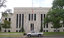
The Van Zandt County Courthouse in Canton
|
|

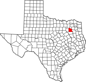
Location within the U.S. state of Texas
|
|
 Texas's location within the U.S. |
|
| Country | |
| State | |
| Founded | 1848 |
| Named for | Isaac Van Zandt |
| Seat | Canton |
| Largest city | Canton |
| Area | |
| • Total | 860 sq mi (2,200 km2) |
| • Land | 843 sq mi (2,180 km2) |
| • Water | 17 sq mi (40 km2) 2.0% |
| Population
(2020)
|
|
| • Total | 59,541 |
| • Density | 69.2/sq mi (26.73/km2) |
| Time zone | UTC−6 (Central) |
| • Summer (DST) | UTC−5 (CDT) |
| Congressional district | 5th |
Van Zandt County is a place in the U.S. state of Texas. It is located in the northeastern part of the state. In 2020, about 59,541 people lived there. The main town, or county seat, is Canton. The county is named after Isaac Van Zandt, who was an important person in the early days of Texas.
Contents
History of Van Zandt County
Van Zandt County is often called the "Free State of Van Zandt." This name was very popular during the Reconstruction Era after the Civil War. People still use it today. There are many stories about how the county got this nickname. Even historians who study the county's past don't fully agree.
One story says the name came from how the county was created. In 1848, Henderson County was divided into three new counties. These were Kaufman, Van Zandt, and what was left of Henderson County. Henderson County had a lot of debt. But the new Van Zandt County started without any debt at all. Many people thought this was a mistake by the state. So, angry citizens and politicians from Henderson County started calling the new county the "Free State."
Attempts to Leave Texas
Van Zandt County tried to separate from Texas two times. The first time was in 1861. This was when Texas decided to leave the United States. About 350 people in Van Zandt County met to protest this decision. Slavery was not common in the county. Slave owners did not bring their slaves to Van Zandt. They worried about losing them in the Civil War.
Most people in Van Zandt County wanted to stay with the United States. They thought if Texas could leave the U.S., then they could leave Texas. They even started to set up their own government. But they were threatened with military action. So, their plan to leave Texas did not work. Still, the name "Free State" stuck with them.
After the Civil War, Texas rejoined the United States. Van Zandt County tried again to leave Texas. This time, they also wanted to leave the Confederate States of America and the United States. In 1867, a meeting was held. Citizens chose people to represent them. These representatives voted to leave. They even wrote their own Declaration of Independence. It was like the United States Declaration of Independence.
The country saw this as a rebellion. When General Sheridan heard about it, he sent soldiers to stop it. The people of Van Zandt held an emergency meeting. They decided to declare war on the United States. The area was very wooded back then. This made it hard for horses to move. The people of Van Zandt knew the area well. They were able to surprise the soldiers. The soldiers had to retreat.
The citizens were very happy about their victory. They celebrated a lot. But during their party, General Sheridan's troops surrounded them. The citizens were put in chains and a rough wooden prison. Two former soldiers, W.A. Allen and Hardy Allen, were among the prisoners. W.A. Allen used a hidden knife to cut through the chains. It also started to rain a lot. The guards were reduced to just one person. This made it easy for the prisoners to escape. After that, not much happened. Arrest warrants were sent out, but no one was arrested. None of the prisoners went to trial.
Geography of Van Zandt County
Van Zandt County covers about 860 square miles. About 17 square miles of this area is water. The county has a unique landscape. The western and northwestern parts are at the edge of the Texas Blackland Prairies. The middle part is in the post oak belt of Northeast Texas. The eastern part reaches into the East Texas Piney Woods.
Two big rivers flow through Van Zandt County. These are the Neches and the Sabine. Van Zandt County is called the "Gateway to East Texas." This is because of its many different types of land.
Major Roads in Van Zandt County
 Interstate 20
 U.S. Highway 80
 State Highway 19
 State Highway 64
 State Highway 110
 State Highway 198
Neighboring Counties
- Rains County (north)
- Wood County (northeast)
- Smith County (east)
- Henderson County (south)
- Kaufman County (west)
- Hunt County (northwest)
Communities in Van Zandt County
Cities
- Canton (county seat)
- Edgewood
- Edom
- Fruitvale
- Grand Saline
- Van
- Wills Point
Census-Designated Places
These are areas that are like towns but are not officially cities.
- Ben Wheeler
- Callender Lake
- Myrtle Springs
Other Small Communities
These are small towns or areas that are not officially cities.
- Alsa
- Colfax
- Martin's Mill
- Midway
- Oakland
- Phalba
- Primrose
- Silver Lake
- Tundra
- Walton
- Wentworth
- Wise
Ghost Towns
These are towns that no longer exist or are mostly empty.
Population and People
| Historical population | |||
|---|---|---|---|
| Census | Pop. | %± | |
| 1850 | 1,348 | — | |
| 1860 | 3,777 | 180.2% | |
| 1870 | 6,494 | 71.9% | |
| 1880 | 12,619 | 94.3% | |
| 1890 | 16,225 | 28.6% | |
| 1900 | 25,481 | 57.0% | |
| 1910 | 25,651 | 0.7% | |
| 1920 | 30,784 | 20.0% | |
| 1930 | 32,315 | 5.0% | |
| 1940 | 31,155 | −3.6% | |
| 1950 | 22,593 | −27.5% | |
| 1960 | 19,091 | −15.5% | |
| 1970 | 22,155 | 16.0% | |
| 1980 | 31,426 | 41.8% | |
| 1990 | 37,944 | 20.7% | |
| 2000 | 48,140 | 26.9% | |
| 2010 | 52,579 | 9.2% | |
| 2020 | 59,541 | 13.2% | |
| U.S. Decennial Census 1850–2010 2010 2020 |
|||
In 2000, there were 48,140 people living in Van Zandt County. There were 18,195 households, which are groups of people living together. About 13,664 of these were families. The county had about 57 people per square mile.
Most people in the county were White (about 92%). About 3% were African American, and less than 1% were Native American or Asian. About 7% of the people were Hispanic or Latino.
In 2000, about 32% of households had children under 18. Most households (63%) were married couples. About 22% of all households had only one person living there. About 17% of the people were 65 years old or older. The average age in the county was 40 years.
Education in Van Zandt County
Several school districts serve the children of Van Zandt County. These districts help students get a good education.
- Canton ISD
- Edgewood ISD
- Fruitvale ISD
- Grand Saline ISD
- Martin's Mill ISD
- Van ISD
- Wills Point ISD
Media and News
Van Zandt County has one local radio station, KWJB. It broadcasts on 1510 AM and 95.1 FM. People in Van Zandt County can also pick up signals from bigger cities. These include TV stations from Dallas/Fort Worth. They also get signals from Tyler/Longview/Jacksonville.
Newspapers and Publications
- Canton Herald
- Wills Point Chronicle
- Canton Guide
- Van Zandt County News
- East Texas Homes and Farms
Transportation
Airports
- Van Zandt County Regional Airport (near Wills Point)
- Canton-Hackney Airport (near Canton)
See also
 In Spanish: Condado de Van Zandt para niños
 | Tommie Smith |
 | Simone Manuel |
 | Shani Davis |
 | Simone Biles |
 | Alice Coachman |


