Wahpeton, North Dakota facts for kids
Quick facts for kids
Wahpeton, North Dakota
|
||
|---|---|---|
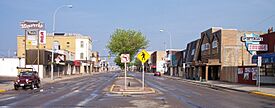
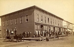
Dakota Avenue in downtown Wahpeton, 2007
|
||
|
||
| Nickname(s):
Home of the Wahpper
|
||
| Country | United States | |
| State | North Dakota | |
| County | Richland | |
| Settled | 1864 | |
| Founded | 1869 | |
| Incorporated (town) | 1882 | |
| Incorporated (city) | 1887 | |
| Area | ||
| • City | 5.355 sq mi (13.869 km2) | |
| • Land | 5.355 sq mi (13.869 km2) | |
| • Water | 0.000 sq mi (0.000 km2) | |
| Elevation | 965 ft (294 m) | |
| Population
(2020)
|
||
| • City | 8,007 | |
| • Estimate
(2023)
|
8,000 | |
| • Density | 1,493.91/sq mi (576.81/km2) | |
| • Urban | 11,290 | |
| • Metro | 22,864 (US: 490th) | |
| Time zone | UTC–6 (Central (CST)) | |
| • Summer (DST) | UTC–5 (CDT) | |
| ZIP Codes |
58074, 58075, 58076
|
|
| Area code(s) | 701 | |
| FIPS code | 38-82660 | |
| GNIS feature ID | 1036311 | |
| Highways | ND 13, ND 210 | |
| Sales tax | 7.0% | |
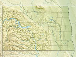
Wahpeton (/ˈwɑːpɪtən/ wah-PIT-ən) is a city in Richland County, located in southeast North Dakota. It sits right where the Bois de Sioux River meets the Otter Tail River, forming the Red River of the North. Wahpeton is the main city of Richland County. In 2020, about 8,007 people lived there.
Wahpeton was started in 1869. It is the main city in the Wahpeton Micropolitan Statistical Area, which includes all of Richland County, North Dakota, and Wilkin County, Minnesota. Wahpeton has a twin city called Breckenridge, Minnesota, which is just across the river. The Bois de Sioux and Otter Tail Rivers join here to create the Red River of the North.
The North Dakota State College of Science is located in Wahpeton. The local newspaper is the Wahpeton Daily News.
Contents
History of Wahpeton
Early Explorers and Settlers
The first European explorer to visit this area was Jonathan Carver in 1767. He was asked by Major Robert Rogers to explore and map the Northwest. Rogers was in charge of Fort Michilimackinac, a British fort that protected a passage between Lake Michigan and Lake Huron. The British had taken over these lands from the French after a war called the Seven Years' War.
Carver was looking for the Northwest Passage, a water route to Asia that many explorers believed existed. He didn't find it, but his journey helped bring fur traders and other explorers to the area.
More than 100 years later, a U.S. government group came through the Wahpeton area. The American Civil War had just ended, and the government wanted to encourage people to move West. J. W. Blanding, a member of this group, was very impressed by the rich river valley. He decided to move his family and belongings from Wisconsin to the Dakota Territory. Many other Wisconsin settlers were also inspired by Blanding and moved to the Wahpeton area even before he did.
The first settler was Morgan T. Rich. He was the first to plow the fertile black soil in 1869. When more settlers arrived, they formed a small community. They named it Richville, honoring both its founder and the rich soil.
Changing Names and Growth
In 1871, a U.S. post office opened in the town. At the same time, the town's name was changed to Chahinkapa. This is a Lakota Sioux word meaning "the end of the woods." Two years later, the county was formed and also named Chahinkapa County.
Later that same year, the county was renamed Richland County. The town of Chahinkapa was renamed Wahpeton. This name comes from the Dakota name of the local Dakota Indian group, the Wakhpetonwan. In Dakota, this name means "leaf dwellers." They got this name from a time when they lived near Lake Mille Lacs, before they were moved by the Ojibwe people.
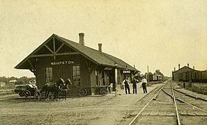
Wahpeton grew slowly at first. But in 1872, growth sped up when a railroad line was completed in Breckenridge, Minnesota, a small town across the Bois de Sioux River. The St. Paul and Pacific Railway (now the Great Northern) came to the region. This railroad led to a boom in building flatboats in both towns. Flatboats could carry goods directly from the railroad down the Red River of the North to northern parts of the state and to Winnipeg, Canada.
The railroad brought many more settlers to the area. These included people from the Eastern United States, Native Americans, and new immigrants from Europe. Many people from Germany, Bohemia (now part of the Czech Republic), and Scandinavia moved to Richland County to claim land. In 1874, Jacob Morvin and Joseph Sittarich opened the first store in Wahpeton. By 1876, so many people were traveling between Wahpeton and Breckenridge that the ferry could not handle it. A bridge was built across the Bois de Sioux River to connect the towns.
Another period of fast growth happened in 1880. The St. Paul, Minneapolis, and Manitoba Railroad crossed the river and built tracks further northwest. By 1883, Wahpeton's population was estimated to be as high as 1,400 people.
Modern Developments
In 1888, the Northern Light Electric Company (NLEC) was started in Wahpeton. This made Wahpeton one of the first cities in North Dakota to have electricity. In 1909, NLEC became the first customer of the new Otter Tail Power Company. In 1913, C. B. Kidder, who owned NLEC, sold his company to Otter Tail Power and became its first general manager. In 1927, Otter Tail Power built its largest power plant in Wahpeton, called Kidder Station. The plant was removed in 1977, and the area is now a park.
In 1889, the Red River Valley University was founded in Wahpeton. It later changed its name to the North Dakota State College of Science.
On June 10, 1897, a sad event happened. A lightning bolt hit the main pole of a Ringling Brothers Circus tent as it was being set up. The pole broke, and three people died. There is a monument in a graveyard south of Wahpeton to remember them. Circus performers still hold a memorial service there when they are in the area.
In 1904, the U.S. government opened the Wahpeton Indian School. This was a boarding school for Native American children from tribes in northern Minnesota, North Dakota, and northern South Dakota. The school aimed to teach children English and Euro-American culture. Today, the school is run by a group of tribes called the Sisseton-Wahpeton Dakota Oyate. It is now called the Circle of Nations School and helps children in grades 4–8.
Geography and Climate
Wahpeton covers about 5.355 square miles (13.87 km2) of land.
The Red River valley is known for its very fertile soil. The river flows north into Canada and forms the border between North Dakota and Minnesota. Wahpeton is located near where the Red River begins, at the meeting point of the Bois de Sioux and Otter Tail Rivers.
Climate in Wahpeton
Wahpeton has a climate with big temperature changes between seasons. Summers are warm to hot and often humid. Winters are cold, sometimes very cold. This type of climate is called a humid continental climate.
Population and People
| Historical population | |||
|---|---|---|---|
| Census | Pop. | %± | |
| 1880 | 400 | — | |
| 1890 | 1,510 | 277.5% | |
| 1900 | 2,228 | 47.5% | |
| 1910 | 2,467 | 10.7% | |
| 1920 | 3,069 | 24.4% | |
| 1930 | 3,176 | 3.5% | |
| 1940 | 3,747 | 18.0% | |
| 1950 | 5,125 | 36.8% | |
| 1960 | 5,876 | 14.7% | |
| 1970 | 7,076 | 20.4% | |
| 1980 | 9,064 | 28.1% | |
| 1990 | 8,751 | −3.5% | |
| 2000 | 8,586 | −1.9% | |
| 2010 | 7,766 | −9.6% | |
| 2020 | 8,007 | 3.1% | |
| 2023 (est.) | 8,000 | 3.0% | |
| U.S. Decennial Census 2020 Census |
|||
In 2022, there were about 3,299 homes in Wahpeton, with an average of 2 people living in each. The average income for a household was about $51,417. About 18.3% of the people in the city live below the poverty line. About 64.8% of the people have jobs. Most adults (92.9%) have a high school diploma, and 22.8% have a college degree or higher.
The most common backgrounds reported by people were German (43.2%), Norwegian (20.0%), and Irish (7.4%).
The average age of people in Wahpeton was 34.0 years old.
Population Changes (2020 Census)
| Race / ethnicity (NH = non-Hispanic) | Pop. 2000 | Pop. 2010 | Pop. 2020 | % 2000 | % 2010 | % 2020 |
|---|---|---|---|---|---|---|
| White alone (NH) | 8,142 | 7,105 | 6,743 | 94.83% | 91.49% | 84.21% |
| Black or African American alone (NH) | 53 | 98 | 131 | 0.62% | 1.26% | 1.64% |
| Native American or Alaska Native alone (NH) | 207 | 217 | 300 | 2.41% | 2.79% | 3.75% |
| Asian alone (NH) | 37 | 61 | 102 | 0.43% | 0.79% | 1.27% |
| Pacific Islander alone (NH) | 3 | 5 | 15 | 0.03% | 0.06% | 0.19% |
| Other race alone (NH) | 3 | 7 | 16 | 0.03% | 0.09% | 0.20% |
| Mixed race or multiracial (NH) | 76 | 117 | 318 | 0.89% | 1.51% | 3.97% |
| Hispanic or Latino (any race) | 65 | 156 | 382 | 0.76% | 2.01% | 4.77% |
| Total | 8,586 | 7,766 | 8,007 | 100.00% | 100.00% | 100.00% |
In 2020, Wahpeton had 8,007 people living there. There were 3,235 households and 1,736 families. The population density was about 1,535.4 inhabitants per square mile (592.8/km2) people per square mile. Most people (85.59%) were White. Other groups included African American (1.64%), Native American (4.17%), and Asian (1.34%). About 4.77% of the population was Hispanic or Latino. About 16.3% of residents were under 18 years old.
Population Details (2010 Census)
In 2010, there were 7,766 people in Wahpeton. There were 3,151 households. About 26.8% of households had children under 18. About 40.7% were married couples. The average household had 2.17 people.
The average age in the city was 31.1 years. About 20.3% of residents were under 18. About 22.2% were between 18 and 24. The city had slightly more males (51.6%) than females (48.4%).
Economy and Jobs
Wahpeton is home to several large factories. These include Woodcraft Industries, WCCO Belting, Minn-Dak Farmers Cooperative, Cargill, ComDel Innovation, Heartland Precision, Doosan/Bobcat, Masonite, and Wil-Rich.
A company called Imation Corporation used to have a factory here, but it closed in 2009.
In 1991, Wahpeton voters approved a small sales tax (1%). This money was used to help the city's economy grow, create jobs, and support businesses. Voters have approved extending this tax several times, and it is currently set to continue until 2026.
Fun Things to Do and Culture
The area is great for people who love the outdoors and hunting. It's in the middle of the Central Flyway, which means many migratory waterfowl (like ducks and geese) pass through, making it a good spot for hunting.
The Bois de Sioux Golf Course is special because half of it is in one state and half is in another! Near the golf course is Chahinkapa Park. This park has playgrounds, fields for baseball, softball, and football, and tennis courts. In the summer, there's a big swimming pool. Chahinkapa Park is also home to the Chahinkapa Zoo. In 2018, the zoo welcomed two white rhinos!
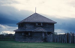
The Richland County Historical Society Museum shows off items from Native American history and displays about pioneer life. Close to Wahpeton, you can find Fort Abercrombie and the Circus Monument. This monument remembers the circus workers who died from a lightning strike in 1897.
The Carmelite Monastery is a peaceful place located a few miles from Wahpeton, by the Wild Rice River.
From June to October, you can visit the Twin Towns Gardeners' Market on Thursday afternoons.
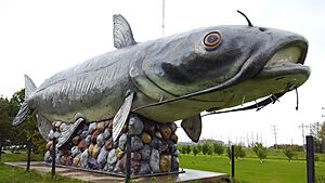
Other fun places to see in Wahpeton include the "Wahpper" – the World's Largest Catfish statue at Kidder Dam. There's also the Bagg Bonanza Farm, a 15-acre (61,000 m2) historic farm with old buildings and machinery. You can also see a mural downtown at Dakota Avenue and 4th Street, and visit the Red Door Art Gallery/Visitor's Center.
Education in Wahpeton
Colleges and Universities
- North Dakota State College of Science
Schools for Kids (K–12)
Wahpeton has two elementary schools, Wahpeton Middle School, and Wahpeton Senior High School. There is also a private school called St. John's Elementary.
The Circle of Nations School (which used to be called Wahpeton Indian School) is a special boarding school for Native American children in grades 4 to 8. It is supported by the Bureau of Indian Education (BIE).
- High School Sports Championships
Wahpeton High School teams have won many state championships:
- State Class 'A' football: 1930, 1971
- State Class 'A' boys basketball: 1941, 1944, 1954, 1979
- State Class 'A' girls basketball: 1986
- State Class 'A' volleyball: 1985, 1986
- State Class 'A' girls golf: 1991
- State Class 'A' wrestling: 2007
- State Class 'A' girls indoor track and field: 1999
Getting Around Wahpeton
Wahpeton has two railroads, a bus line, five truck lines, and an airport. The airport has runways that are about 3,000 and 5,000 feet (1,500 m) long.
Local Transportation
Valley Senior Services offers a dial-a-ride bus service for Wahpeton residents on weekdays.
Main Roads
 ND 13
ND 13 ND 127
 ND 210 (This road acts as a bypass for Wahpeton. It crosses the river just north of Breckenridge, MN, becomes
  MN 210, and then meets
  US 75.)
Famous People from Wahpeton
- Art Anderson, former NFL football player
- Sam Anderson, actor
- Anna Astvatsaturian Turcotte, Armenian-American writer
- Louise Erdrich (Chippewa), author, lived here as a child
- Sidney Hinds, Brigadier General and Olympian
- Rose Thompson Hovick, inspired "Rose" character of musical Gypsy
- Woodrow W. Keeble, World War II and Korean War hero
- Colin Masica, linguist
- Porter J. McCumber, former senator
- Jerome G. Miller, correctional institution reformer
- Steve Myhra, former placekicker for the Baltimore Colts
- William E. Purcell, former senator
- David Richman, North Dakota State men's basketball head coach
- Mary Shaw Shorb, research scientist
- Ryan Smith, wide receiver, Winnipeg Blue Bombers
- Russell T. Thane, long-time state senator
- John Wall, North Dakota educator and politician
- Clark Williams, state legislator
See also
 In Spanish: Wahpeton (Dakota del Norte) para niños
 | Delilah Pierce |
 | Gordon Parks |
 | Augusta Savage |
 | Charles Ethan Porter |


