
Wasseramt District facts for kids
The Wasseramt District is one of the ten main areas, called districts, in the Solothurn canton in Switzerland. It's located in the southern part of the canton. This district, along with the Bucheggberg District, forms a larger area called an Amtei, which is used for elections. As of 31 December 2020, about 52,949 people live in Wasseramt.


Contents
Towns and Villages in Wasseramt
The Wasseramt District is made up of several smaller towns and villages, which are called municipalities. Each municipality has its own local government.
| Coat of arms | Municipality | Population (31 December 2020) |
Area, km² |
|---|---|---|---|
| Aeschi | 1,268 | 5.48 | |
| Biberist | 9,109 | 12.24 | |
| Bolken | 590 | 2.13 | |
| Deitingen | 2,227 | 7.63 | |
| Derendingen | 6,592 | 5.62 | |
| Drei Höfe | 748 | 4.58 | |
| Etziken | 973 | 3.38 | |
| Gerlafingen | 5,502 | 1.91 | |
| Halten | 850 | 1.85 | |
| Horriwil | 836 | 2.60 | |
| Hüniken | 153 | 1.01 | |
| Kriegstetten | 1,292 | 1.13 | |
| Lohn-Ammannsegg | 2,870 | 4.46 | |
| Luterbach | 3,555 | 4.54 | |
| Obergerlafingen | 1,247 | 1.52 | |
| Oekingen | 878 | 2.45 | |
| Recherswil | 2,028 | 3.33 | |
| Subingen | 3,173 | 6.22 | |
| Zuchwil | 9,058 | 4.67 | |
| Total | 52,949 | 76.62 |
Changes to Municipalities
Over the years, some municipalities in Wasseramt have joined together or changed their names. This helps them work better as a community.
- On January 1, 1993, Heinrichswil and Winistorf became one municipality called Heinrichswil-Winistorf. At the same time, Ammannsegg and Lohn joined to form Lohn-Ammannsegg. Also, Burgäschi became part of Aeschi.
- On January 1, 2012, Steinhof merged into the municipality of Aeschi.
- On January 1, 2013, Heinrichswil-Winistorf and Hersiwil merged to create the new municipality of Drei Höfe.
Geography and Land Use
Wasseramt covers an area of about 76.63 square kilometers (29.59 sq mi). This land is used for different purposes:
- Almost half of the land (47.0%) is used for farming. This includes growing crops and some areas for fruit trees.
- About a quarter of the district (26.2%) is covered by forests. Most of this is dense forest, with some smaller groups of trees.
- A significant part (25.2%) is developed land, meaning it has buildings or roads. This includes industrial areas, homes, and transportation routes.
- A small portion (1.4%) consists of rivers and lakes.
- A very small amount (0.1%) is unproductive land, like rocky areas.
District Symbols: Coat of Arms

The official symbol of the Wasseramt district is its coat of arms. It shows a design of red and silver stripes that go diagonally across the shield. This design is called Bendy sinistery Gules and Argent.
Population and People
As of 31 December 2020, the Wasseramt District has a population of about 52,949 people.
Languages Spoken
In 2000, most people in Wasseramt spoke German (about 86.9%). The next most common languages were Italian (3.8%) and Serbo-Croatian (2.1%). A smaller number of people spoke French or Romansh.
Population Makeup
In 2008, the population was almost evenly split between males (49.5%) and females (50.5%).
- About 37.2% of the population were Swiss men, and 39.9% were Swiss women.
- About 12.3% were non-Swiss men, and 10.6% were non-Swiss women.
Many people living in Wasseramt were born there (27.0%) or in the same canton (27.9%). Others came from different parts of Switzerland (24.2%) or from other countries (17.7%).
Population Changes
In 2008, the number of Swiss citizens in the district slightly decreased, while the number of non-Swiss residents increased. This was due to more non-Swiss people moving into the district than leaving. Overall, the population grew by 0.4% that year.
Family Life
In 2000, about 27.0% of the people in the district were single and had never been married. Most people were married (48.7%), while others were widowed, divorced, or single parents.
There were many different types of households:
- About 30.6% of households had only one person living in them.
- Many households were married couples, some with children and some without.
- There were also single parents living with their children.
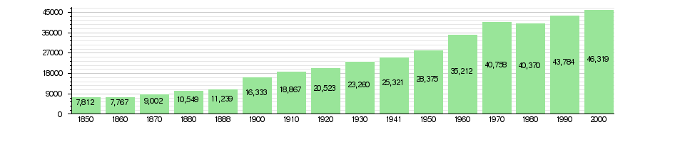
Historical Population Growth
The chart below shows how the population of Wasseramt has changed over many years. You can see how it has grown significantly, especially in the 20th century.
Politics and Elections
In the 2007 federal election, people in Wasseramt voted for different political parties. The most popular party was the SVP, which received about 25.86% of the votes. Other popular parties included the SP (23.31%), the FDP (19.91%), and the CVP (18.69%). About 46.9% of eligible voters participated in this election.
Religion in the District
According to the 2000 census, the population of Wasseramt follows various religions:
- About 35.4% of people were Roman Catholic.
- Another 35.4% belonged to the Swiss Reformed Church.
- Smaller groups included members of an Orthodox church (1.98%), the Christian Catholic Church (0.46%), and other Christian churches (1.77%).
- There were also people who followed Islam (6.95%), Buddhism (0.28%), and Hinduism (0.75%).
- About 14.11% of the population did not belong to any church, or identified as agnostic or atheist.
Education System
Education is very important in Wasseramt.
- About 38.7% of the people have finished non-mandatory upper secondary education, which is like high school.
- About 10.4% have gone on to higher education, such as a university or a specialized college.
School System Structure
During the 2010–2011 school year, there were 736 students in the Wasseramt school district.
- In the Canton of Solothurn, young children can attend two years of non-required Kindergarten.
- Students then go to six years of primary school.
- After primary school, students attend three years of required secondary school. Following this, they can choose to go to optional advanced schools for three to five more years.
See also
 In Spanish: Distrito de Wasseramt para niños
