Watonwan County, Minnesota facts for kids
Quick facts for kids
Watonwan County
|
|
|---|---|

|
|

Location within the U.S. state of Minnesota
|
|
 Minnesota's location within the U.S. |
|
| Country | |
| State | |
| Founded | February 25, 1860 |
| Named for | Watonwan River |
| Seat | St. James |
| Largest city | St. James |
| Area | |
| • Total | 440 sq mi (1,100 km2) |
| • Land | 435 sq mi (1,130 km2) |
| • Water | 4.8 sq mi (12 km2) 1.1%% |
| Population
(2020)
|
|
| • Total | 11,253 |
| • Estimate
(2023)
|
11,077 |
| • Density | 25.9/sq mi (10.0/km2) |
| Time zone | UTC−6 (Central) |
| • Summer (DST) | UTC−5 (CDT) |
| Congressional district | 1st |
Watonwan County is a county located in the state of Minnesota in the United States. In 2020, about 11,253 people lived there. The main town and government center of the county is St. James.
Contents
History of Watonwan County
The story of Watonwan County began in 1849. That year, the new government of the Minnesota Territory created nine large counties.
A few years later, in 1853, a big part of Dakota County was separated to form Blue Earth County. Then, in 1855, the western part of Blue Earth County was used to create Brown County.
Finally, on February 25, 1860, the southern part of Brown County was separated to create Watonwan County. The first county seat, or main town, was Madelia.
The county gets its name from the Watonwan River. This river flows into the Blue Earth River, then the Minnesota River, and finally into the mighty Mississippi River. The name "Watonwan" comes from the Dakota language. It means "fish bait" or "plenty of fish." This name for the river first appeared on a map in 1843.
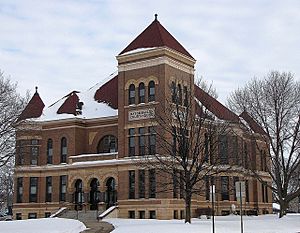
In 1869, the first European settlers arrived in the area where the town of Saint James would later grow. By 1870, a railway line called the St. Paul and Sioux City Railway reached the village. The railway officials decided to name this new train stop Saint James. The town grew quickly. By 1878, it was big enough that people voted to move the county seat and courthouse from Madelia to Saint James.
Geography of Watonwan County
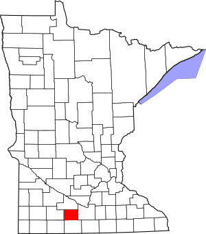
Watonwan County has gentle, rolling hills. It has many small rivers and streams, and some lakes and ponds. Most of the land is used for farming. The land generally slopes down towards the north and east. The highest point in the county is in the southwest, about 1,293 feet (394 m) above sea level.
The county covers about 440 square miles (1,100 km2). Most of this is land (435 sq mi or 1,127 km2), with about 4.8 square miles (12 km2) being water. The Watonwan River and its smaller streams flow through the northern part of the county, draining the land.
Main Roads
 Minnesota State Highway 4
 Minnesota State Highway 15
 Minnesota State Highway 30
 Minnesota State Highway 60
Airports in Watonwan County
- St. James Municipal Airport (JYG, LID) is about 3 miles (5 km) east of St. James.
Neighboring Counties
- Brown County - to the north
- Blue Earth County - to the east
- Martin County - to the south
- Jackson County - to the southwest
- Cottonwood County - to the west
Protected Natural Areas
- Bergdahl State Wildlife Management Area
- Lewisville State Wildlife Management Area
- Turtle Marsh State Wildlife Management Area
- Wilson State Wildlife Management Area
- Woodlake State Wildlife Management Area
Lakes in Watonwan County
- Bergdahl Lake
- Bullhead Lake
- Butterfield Lake
- Case Lake
- Cottonwood Lake
- Ewy Lake
- Fedji Lake
- Irish Lake
- Long Lake
- Mary Lake
- Mud Lake
- Kansas Lake
- Saint James Lake
- School Lake
- Sulem Lake
- Wilson Lake
- Wood Lake (part)
Population of Watonwan County
| Historical population | |||
|---|---|---|---|
| Census | Pop. | %± | |
| 1870 | 2,426 | — | |
| 1880 | 5,104 | 110.4% | |
| 1890 | 7,746 | 51.8% | |
| 1900 | 11,496 | 48.4% | |
| 1910 | 11,332 | −1.4% | |
| 1920 | 12,457 | 9.9% | |
| 1930 | 12,802 | 2.8% | |
| 1940 | 13,902 | 8.6% | |
| 1950 | 13,881 | −0.2% | |
| 1960 | 14,460 | 4.2% | |
| 1970 | 13,298 | −8.0% | |
| 1980 | 12,361 | −7.0% | |
| 1990 | 11,682 | −5.5% | |
| 2000 | 11,876 | 1.7% | |
| 2010 | 11,211 | −5.6% | |
| 2020 | 11,253 | 0.4% | |
| 2023 (est.) | 11,077 | −1.2% | |
| U.S. Decennial Census 1790-1960 1900-1990 1990-2000 2010-2020 |
|||
2020 Census Information
In 2020, the United States Census counted 11,253 people living in Watonwan County.
| Race | Num. | Perc. |
|---|---|---|
| White (not Hispanic) | 7,689 | 68.33% |
| Black or African American (not Hispanic) | 42 | 0.37% |
| Native American (not Hispanic) | 13 | 0.12% |
| Asian (not Hispanic) | 86 | 0.76% |
| Pacific Islander (not Hispanic) | 0 | 0% |
| Other/Mixed (not Hispanic) | 196 | 1.74% |
| Hispanic or Latino | 3,227 | 28.7% |
2000 Census Information
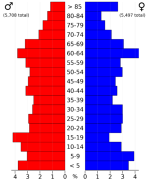
According to the census in 2000, there were 11,876 people in the county. Most people were White (88.54%). About 15.19% of the population was Hispanic or Latino. Many people had German (40.9%), Norwegian (17.3%), or Swedish (5.8%) family backgrounds.
The average age in the county was 39 years old. About 27.60% of the people were under 18.
Towns and Communities
Cities in Watonwan County
- Butterfield
- Darfur
- La Salle
- Lewisville
- Madelia
- Odin
- Ormsby (partly in Martin County)
- St. James (the county seat)
Small Communities and Villages
- Echols
- Godahl (partial)
- Grogan
- South Branch
- Sveadahl
- Tenmile Corner
Townships in Watonwan County
- Adrian Township
- Antrim Township
- Butterfield Township
- Fieldon Township
- Long Lake Township
- Madelia Township
- Nelson Township
- Odin Township
- Riverdale Township
- Rosendale Township
- St. James Township
- South Branch Township
See also
 In Spanish: Condado de Watonwan para niños


