Westmoreland Parish facts for kids
Quick facts for kids
Westmoreland
Wesmolan
|
|
|---|---|
|
Parish
|
|

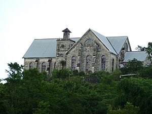
Carmel Moravian Church
|
|

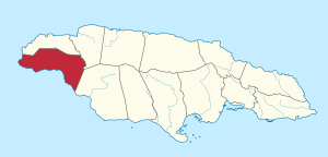
Westmoreland in Jamaica
|
|
| Country | Jamaica |
| County | Cornwall |
| Capital | Savanna-la-Mar |
| Area | |
| • Total | 807 km2 (312 sq mi) |
| Area rank | 8 |
| Population
(2019)
|
|
| • Total | 149,857 |
| • Density | 185.70/km2 (480.95/sq mi) |
Westmoreland is the westernmost parish in Jamaica. It is found on the south side of the island. This parish is located south of Hanover and southwest of Saint James. It is also northwest of Saint Elizabeth. Westmoreland is part of the county of Cornwall. The main town and capital city is Savanna-la-Mar. Negril, a very popular place for tourists, is also in this parish.
Contents
History of Westmoreland
Early Inhabitants
The first people to live in Westmoreland were the Arawak and Ciboney Indians. The Ciboney arrived first, coming from South America around 500 BC. They were known as "cave dwellers" because they lived in caves along the cliffs of Negril. The many caves and paths under what is now the Xtabi Hotel in Negril are some of the first known homes of the Ciboney Indians in Jamaica.
European Arrival and English Rule
Christopher Columbus visited the area that became Westmoreland during his second trip to Jamaica. One of the first Spanish settlements was built at Bluefields in this parish.
The English took control of the island from the Spanish in 1655. In 1703, the English colonists named the parish Westmoreland. They chose this name because it was the most western part of the island. In 1730, Savanna-la-Mar, a port city on the coast, became the new capital of the parish. A fort was built there in the 1700s to protect the port from pirates. Today, this fort is an important historical site in the parish.
Sugar Plantations and Labor
In the mid-1700s, Westmoreland was one of the most profitable areas in Jamaica. It was also very profitable throughout the British Empire. The flat lands of Westmoreland had many sugar plantations. By the time of Tacky's War, over 60 sugar plantations were operating here. Many people were forced to work on these plantations.
Road to Independence
In 1938, important events happened at the Frome sugar estate. These events changed Jamaica's history forever. After these events, the government passed new laws in 1944. These laws gave all adults the right to vote, which is called suffrage. A new constitution was also approved. This set Jamaica on the path to ruling itself and eventually becoming an independent country. Two national heroes, Sir Alexander Bustamante and Norman Washington Manley, became important political leaders during this time.
Geography of Westmoreland
Westmoreland covers an area of 807 square kilometers (312 square miles). This makes it Jamaica's eighth-largest parish. The population of Westmoreland is about 144,817 people. Many residents are descendants of people from East India. These people came to Jamaica as indentured laborers after Britain ended slavery in 1834. They came to work because there was still a great need for workers. Many of them married people of African descent. Their mixed-race descendants are sometimes called "half indian" locally.
Natural Features
Westmoreland has over 10,000 acres (40 square kilometers) of marsh land. The biggest part of this is called the Great Morass. This marsh contains plant and animal material that has built up over hundreds of years. This material can be used as peat, which is a good source of energy. The marsh is also a special home for many different Jamaican wildlife and birds. The rest of the parish has some hills of medium height and flat lands along the coast.
Many rivers flow through Westmoreland. The Cabaritta River is 39.7 kilometers (24.7 miles) long. It drains the George's Plain and can even be used by ships weighing up to eight tons. Other rivers include the Negril, New Savanna, Morgan's, Gut, Smithfield, Bowens, Bluefields, Robins, Roaring, Great, and Dean rivers.
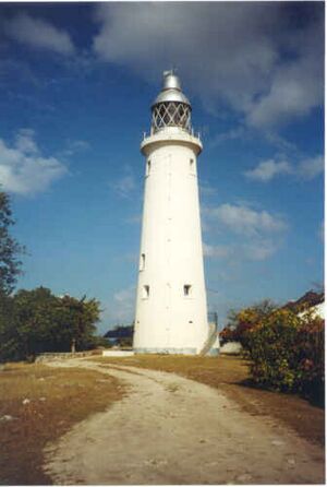
The very western tip of the island is called Negril Point. This is where you can find the Negril Lighthouse.
Education in Westmoreland
Westmoreland has several secondary schools. These include Manning's School, Frome Technical High School, and Grange Hill High School.
Commerce and Economy
Westmoreland's economy relies heavily on agriculture because of its fertile plains. The main crop is sugarcane, which provides many jobs. Other farm products include bananas, coffee, ginger, cocoa, pimento, honey, rice, and breadfruit.
Raising animals, known as pastoralism, is also common. Farmers raise cattle, horses, and mules. Fishing is another important industry. There are 19 fishing beaches with over 90 boats. Manufacturing is the third largest part of the economy. Factories here make food and drinks, tobacco, animal feed, and textile products.
Tourism in Westmoreland
Negril is one of the most popular tourist destinations in Jamaica. Since the 1950s, tourism has grown very quickly. Major hotels include Couples Swept Away and Poinciana Beach Resort. There are also more than 200 other resorts and over 200 bars and restaurants in the area.
Attractions to Visit
- Bridgewater
- Mayfield Falls
- Negril
- Petersfield
- Roaring River Park
- Savanna-la-Mar
- Seaford Town
See also
 In Spanish: Parroquia de Westmoreland para niños Mount Charles, a large hill in Westmoreland Parish.
 | Valerie Thomas |
 | Frederick McKinley Jones |
 | George Edward Alcorn Jr. |
 | Thomas Mensah |


