Wyoming statistical areas facts for kids
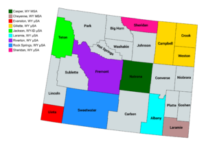
Wyoming has special areas called statistical areas. These areas are defined by a group called the Office of Management and Budget (OMB). They help us understand where people live and how different places are connected. As of July 2023, Wyoming has ten statistical areas: two are metropolitan statistical areas (for bigger cities) and eight are micropolitan statistical areas (for smaller towns). The largest of these is the Cheyenne, WY Metropolitan Statistical Area, which had about 100,512 people in 2020.
Contents
What Are Statistical Areas?
The Office of Management and Budget (OMB) creates over 1,000 statistical areas across the United States and Puerto Rico. These areas are important for understanding how people are grouped together. They are used by the government and other groups to help with planning and services.
Core-Based Statistical Areas
The OMB uses a term called Core-Based Statistical Area (CBSA). A CBSA is an area that includes at least one main town or city with 10,000 or more people. It also includes nearby counties where many people travel to and from the main city for work or shopping. This shows that the areas are connected.
CBSAs are divided into two types:
- Metropolitan Statistical Areas (MSAs): These are for larger cities. An MSA must have at least 50,000 people.
- Micropolitan Statistical Areas (μSAs): These are for smaller towns. A μSA has between 10,000 and 50,000 people.
Combined Statistical Areas
Sometimes, two or more nearby CBSAs are very connected. This means many people travel between them for work. When this happens, they can be grouped into a Combined Statistical Area (CSA).
Wyoming's Statistical Areas
Wyoming has 10 statistical areas. The table below shows these areas and the counties that belong to them. It also shows how many people lived in each area and county in 2020.
 | James Van Der Zee |
 | Alma Thomas |
 | Ellis Wilson |
 | Margaret Taylor-Burroughs |


